Ormond Scenic Loop & Trail - Florida Scenic Highways
Ormond Scenic Loop & Trail - Florida Scenic Highways
Ormond Scenic Loop & Trail - Florida Scenic Highways

You also want an ePaper? Increase the reach of your titles
YUMPU automatically turns print PDFs into web optimized ePapers that Google loves.
<strong>Ormond</strong> <strong>Scenic</strong> <strong>Loop</strong> & <strong>Trail</strong> – Corridor Management Plan<br />
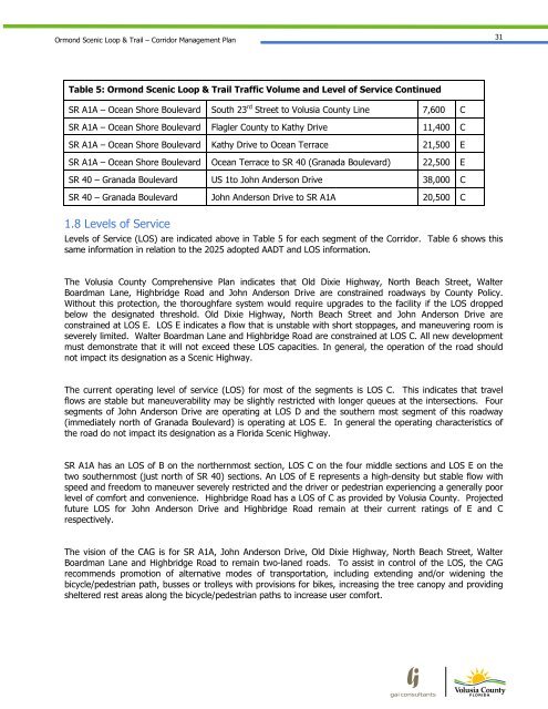
31<br />
Table 5: <strong>Ormond</strong> <strong>Scenic</strong> <strong>Loop</strong> & <strong>Trail</strong> Traffic Volume and Level of Service Continued<br />
SR A1A – Ocean Shore Boulevard South 23 rd Street to Volusia County Line 7,600 C<br />
SR A1A – Ocean Shore Boulevard Flagler County to Kathy Drive 11,400 C<br />
SR A1A – Ocean Shore Boulevard Kathy Drive to Ocean Terrace 21,500 E<br />
SR A1A – Ocean Shore Boulevard Ocean Terrace to SR 40 (Granada Boulevard) 22,500 E<br />
SR 40 – Granada Boulevard US 1to John Anderson Drive 38,000 C<br />
SR 40 – Granada Boulevard John Anderson Drive to SR A1A 20,500 C<br />
1.8 Levels of Service<br />
Levels of Service (LOS) are indicated above in Table 5 for each segment of the Corridor. Table 6 shows this<br />
same information in relation to the 2025 adopted AADT and LOS information.<br />
The Volusia County Comprehensive Plan indicates that Old Dixie Highway, North Beach Street, Walter<br />
Boardman Lane, Highbridge Road and John Anderson Drive are constrained roadways by County Policy.<br />
Without this protection, the thoroughfare system would require upgrades to the facility if the LOS dropped<br />
below the designated threshold. Old Dixie Highway, North Beach Street and John Anderson Drive are<br />
constrained at LOS E. LOS E indicates a flow that is unstable with short stoppages, and maneuvering room is<br />
severely limited. Walter Boardman Lane and Highbridge Road are constrained at LOS C. All new development<br />
must demonstrate that it will not exceed these LOS capacities. In general, the operation of the road should<br />
not impact its designation as a <strong>Scenic</strong> Highway.<br />
The current operating level of service (LOS) for most of the segments is LOS C. This indicates that travel<br />
flows are stable but maneuverability may be slightly restricted with longer queues at the intersections. Four<br />
segments of John Anderson Drive are operating at LOS D and the southern most segment of this roadway<br />
(immediately north of Granada Boulevard) is operating at LOS E. In general the operating characteristics of<br />
the road do not impact its designation as a <strong>Florida</strong> <strong>Scenic</strong> Highway.<br />
SR A1A has an LOS of B on the northernmost section, LOS C on the four middle sections and LOS E on the<br />
two southernmost (just north of SR 40) sections. An LOS of E represents a high-density but stable flow with<br />
speed and freedom to maneuver severely restricted and the driver or pedestrian experiencing a generally poor<br />
level of comfort and convenience. Highbridge Road has a LOS of C as provided by Volusia County. Projected<br />
future LOS for John Anderson Drive and Highbridge Road remain at their current ratings of E and C<br />
respectively.<br />
The vision of the CAG is for SR A1A, John Anderson Drive, Old Dixie Highway, North Beach Street, Walter<br />
Boardman Lane and Highbridge Road to remain two-laned roads. To assist in control of the LOS, the CAG<br />
recommends promotion of alternative modes of transportation, including extending and/or widening the<br />
bicycle/pedestrian path, busses or trolleys with provisions for bikes, increasing the tree canopy and providing<br />
sheltered rest areas along the bicycle/pedestrian paths to increase user comfort.