Ormond Scenic Loop & Trail - Florida Scenic Highways
Ormond Scenic Loop & Trail - Florida Scenic Highways
Ormond Scenic Loop & Trail - Florida Scenic Highways

Create successful ePaper yourself
Turn your PDF publications into a flip-book with our unique Google optimized e-Paper software.
<strong>Ormond</strong> <strong>Scenic</strong> <strong>Loop</strong> & <strong>Trail</strong> – Corridor Management Plan<br />
104<br />
Section 5: Corridor’s Story<br />
The communities surrounding The <strong>Ormond</strong> <strong>Scenic</strong> <strong>Loop</strong> and <strong>Trail</strong> have a<br />
long, rich history that begins approximately 20,000 years ago during the<br />
last Glacial Period and is closely linked to three bodies of water – the<br />
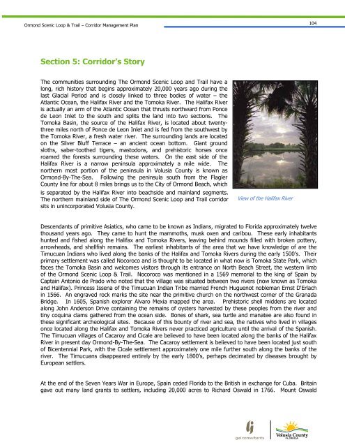
Atlantic Ocean, the Halifax River and the Tomoka River. The Halifax River<br />
is actually an arm of the Atlantic Ocean that thrusts northward from Ponce<br />
de Leon Inlet to the south and splits the land into two sections. The<br />
Tomoka Basin, the source of the Halifax River, is located about twentythree<br />
miles north of Ponce de Leon Inlet and is fed from the southwest by<br />
the Tomoka River, a fresh water river. The surrounding lands are located<br />
on the Silver Bluff Terrace – an ancient ocean bottom. Giant ground<br />
sloths, saber-toothed tigers, mastodons, and prehistoric horses once<br />
roamed the forests surrounding these waters. On the east side of the<br />
Halifax River is a narrow peninsula approximately a mile wide. The<br />
northern most portion of the peninsula in Volusia County is known as<br />
<strong>Ormond</strong>-By-The-Sea. Following the peninsula south from the Flagler<br />
County line for about 8 miles brings us to the City of <strong>Ormond</strong> Beach, which<br />
is separated by the Halifax River into beachside and mainland segments.<br />
The northern mainland side of The <strong>Ormond</strong> <strong>Scenic</strong> <strong>Loop</strong> and <strong>Trail</strong> corridor<br />
sits in unincorporated Volusia County.<br />
View of the Halifax River<br />
Descendants of primitive Asiatics, who came to be known as Indians, migrated to <strong>Florida</strong> approximately twelve<br />
thousand years ago. They came to hunt the mammoths, musk oxen and caribou. These early inhabitants<br />
hunted and fished along the Halifax and Tomoka Rivers, leaving behind mounds filled with broken pottery,<br />
arrowheads, and shellfish remains. The earliest inhabitants of the area that we have knowledge of are the<br />
Timucuan Indians who lived along the banks of the Halifax and Tomoka Rivers during the early 1500’s. Their<br />
primary settlement was called Nocoroco and is thought to be located in what now is Tomoka State Park, which<br />
faces the Tomoka Basin and welcomes visitors through its entrance on North Beach Street, the western limb<br />
of the <strong>Ormond</strong> <strong>Scenic</strong> <strong>Loop</strong> & <strong>Trail</strong>. Nocoroco was mentioned in a 1569 memorial to the king of Spain by<br />
Captain Antonio de Prado who noted that the village was situated between two rivers (now known as Tomoka<br />
and Halifax). Princess Issena of the Timucuan Indian Tribe married French Huguenot nobleman Ernst D'Erlach<br />
in 1566. An engraved rock marks the site near the primitive church on the northwest corner of the Granada<br />
Bridge. In 1605, Spanish explorer Alvaro Mexia mapped the area. Prehistoric shell middens are located<br />
along John Anderson Drive containing the remains of oysters harvested by these peoples from the river and<br />
tiny coquina clams gathered from the ocean side. Bones of shark, sea turtle and manatee are also found in<br />
these significant archeological sites. Because of this bounty of river and sea, the natives who lived in villages<br />
once located along the Halifax and Tomoka Rivers never practiced agriculture until the arrival of the Spanish.<br />
The Timucuan villages of Cacaroy and Cicale are believed to have been located along the banks of the Halifax<br />
River in present day <strong>Ormond</strong>-By-The-Sea. The Cacaroy settlement is believed to have been located just south<br />
of Bicentennial Park, with the Cicale settlement approximately one mile further south along the banks of the<br />
river. The Timucuans disappeared entirely by the early 1800’s, perhaps decimated by diseases brought by<br />
European settlers.<br />
At the end of the Seven Years War in Europe, Spain ceded <strong>Florida</strong> to the British in exchange for Cuba. Britain<br />
gave out many land grants to settlers, including 20,000 acres to Richard Oswald in 1766. Mount Oswald