The evolution of Jumpinpin Inlet - OzCoasts
The evolution of Jumpinpin Inlet - OzCoasts
The evolution of Jumpinpin Inlet - OzCoasts

You also want an ePaper? Increase the reach of your titles
YUMPU automatically turns print PDFs into web optimized ePapers that Google loves.
<strong>The</strong> <strong>evolution</strong> <strong>of</strong> <strong>Jumpinpin</strong> <strong>Inlet</strong><br />
(a) domination <strong>of</strong> tidal flow outward <strong>of</strong> the inlet, sufficient to counteract wave-induced<br />
onshore sediment movement; and/or (b) that efficient natural sand bypassing is<br />
occurring.<br />
<strong>The</strong> ebb-tidal delta at <strong>Jumpinpin</strong> is <strong>of</strong>fset, protruding farther seaward on the downdrift<br />
side than the updrift side <strong>of</strong> the inlet. Along wave-dominated coasts the longshore<br />
currents dominate the sediment dispersal pattern. Consequently, the barrier islands<br />
flanking <strong>Jumpinpin</strong> have become long and continuous while the ebb delta remains<br />
small because <strong>of</strong> rapid dispersal <strong>of</strong> its sediment by waves.<br />
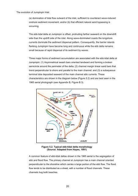
Three major forms <strong>of</strong> sediment accumulation are associated with the ebb-tidal delta at<br />
<strong>Jumpinpin</strong>: (1) Asymmetrical swash bars oriented landward and forming a broken<br />
semicircle around the perimeter <strong>of</strong> the delta; (2) channel margin linear sand bars that<br />
trend perpendicular to shore and parallel to the main channel; and (3) a subaqueous<br />
terminal lobe deposited seaward <strong>of</strong> the main channel ebb currents. <strong>The</strong>se<br />
characteristics are shown in the diagram below (Figure 5.2) and are best seen in the<br />
1965 aerial photograph (see Appendix B, Figure B.3).<br />
Figure 5.2. Typical ebb-tidal delta morphology<br />
(Source: Adapted from Hayes, 1991)<br />
A common feature <strong>of</strong> ebb-tidal deltas shown in the 1965 aerial is the segregation <strong>of</strong><br />
ebb and flood flow. <strong>The</strong> primary channel at <strong>Jumpinpin</strong> has a main channel oriented<br />
perpendicular to the shoreline which carries a large portion <strong>of</strong> the ebb flow. <strong>The</strong> flood<br />
flow tends to be distributed as a sheet, with a number <strong>of</strong> flood channels. <strong>The</strong>se<br />
channels hug both beaches.<br />
20