Download - FRA Nepal
Download - FRA Nepal
Download - FRA Nepal

You also want an ePaper? Increase the reach of your titles
YUMPU automatically turns print PDFs into web optimized ePapers that Google loves.
7.4.5 Other Development Activities<br />
7.4.5.1 NTFPs<br />
While planning and carrying out the assessment of NTFPs, the following issues should be studied:<br />
7.4.5.2 TOF<br />
1. Identify and list the tree associated NTFP products, which can be surveyed as a part of the standard <strong>FRA</strong>, i.e.<br />
bark, leaves, fruit, etc.<br />
2. Find the NTFPs, whose habitat is known. Group these according to habitat types: altitude, east-west and habitat<br />
type matrix.<br />
3. Define indicators, which characterize these habitats. Indicators should preferably be such that they can be<br />
detected by means of remote sensing. Concise habitat mapping provides some information concerning<br />
production and harvest potential of these NTFP’s. Habitats can be used as sample units for further analysis and<br />
field surveys.<br />
4. The survey and its design should be made in close cooperation with local forest officials, traders, local healers,<br />
collectors, community forest user groups, local people, etc.<br />
5. Importance values and Prominence values will be used for the quantification of NTFPs.<br />
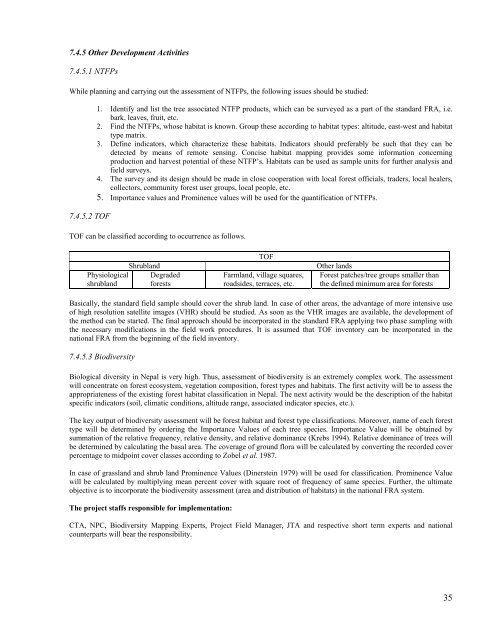
TOF can be classified according to occurrence as follows.<br />
Physiological<br />
shrubland<br />
Shrubland<br />
Degraded<br />
forests<br />
TOF<br />
Farmland, village squares,<br />
roadsides, terraces, etc.<br />
Other lands<br />
Forest patches/tree groups smaller than<br />
the defined minimum area for forests<br />
Basically, the standard field sample should cover the shrub land. In case of other areas, the advantage of more intensive use<br />
of high resolution satellite images (VHR) should be studied. As soon as the VHR images are available, the development of<br />
the method can be started. The final approach should be incorporated in the standard <strong>FRA</strong> applying two phase sampling with<br />
the necessary modifications in the field work procedures. It is assumed that TOF inventory can be incorporated in the<br />
national <strong>FRA</strong> from the beginning of the field inventory.<br />
7.4.5.3 Biodiversity<br />
Biological diversity in <strong>Nepal</strong> is very high. Thus, assessment of biodiversity is an extremely complex work. The assessment<br />
will concentrate on forest ecosystem, vegetation composition, forest types and habitats. The first activity will be to assess the<br />
appropriateness of the existing forest habitat classification in <strong>Nepal</strong>. The next activity would be the description of the habitat<br />
specific indicators (soil, climatic conditions, altitude range, associated indicator species, etc.).<br />
The key output of biodiversity assessment will be forest habitat and forest type classifications. Moreover, name of each forest<br />
type will be determined by ordering the Importance Values of each tree species. Importance Value will be obtained by<br />
summation of the relative frequency, relative density, and relative dominance (Krebs 1994). Relative dominance of trees will<br />
be determined by calculating the basal area. The coverage of ground flora will be calculated by converting the recorded cover<br />
percentage to midpoint cover classes according to Zobel et al. 1987.<br />
In case of grassland and shrub land Prominence Values (Dinerstein 1979) will be used for classification. Prominence Value<br />
will be calculated by multiplying mean percent cover with square root of frequency of same species. Further, the ultimate<br />
objective is to incorporate the biodiversity assessment (area and distribution of habitats) in the national <strong>FRA</strong> system.<br />
The project staffs responsible for implementation:<br />
CTA, NPC, Biodiversity Mapping Experts, Project Field Manager, JTA and respective short term experts and national<br />
counterparts will bear the responsibility.<br />
35