

Lower Pilarcitos Creek Groundwater Basin Study - Coastside ...
Lower Pilarcitos Creek Groundwater Basin Study - Coastside ...
Lower Pilarcitos Creek Groundwater Basin Study - Coastside ...

Create successful ePaper yourself
Turn your PDF publications into a flip-book with our unique Google optimized e-Paper software.
In addition, 128 wells have been drilled in the Half Moon Bay area for crop and<br />
landscape irrigation. Within the groundwater basin, the cropland relying on wells for<br />
irrigation supply is clustered along lower <strong>Pilarcitos</strong> <strong>Creek</strong> and near the confluence of<br />
Arroyo Leon and <strong>Pilarcitos</strong> <strong>Creek</strong>. About 10 agricultural irrigation wells are still active in<br />
the groundwater basin. Wells for landscaping irrigation include Ocean Colony Partners’<br />
wells located along Balboa Boulevard near <strong>Pilarcitos</strong> <strong>Creek</strong>.<br />
The Ocean Colony Partners Balboa wellfield is the most important groundwater<br />
user in the basin. The wellfield consists of four, relatively low-capacity wells that are<br />
pumped to provide water supply for two golf courses, the Half Moon Bay Golf Links<br />
located south of the groundwater basin. The wellfield initially was developed in the early<br />
1980s as the supply for one golf course, pumping an average of 207 acre-feet per year<br />
(AFY), while current pumping for the two golf courses averages 347 AFY (Luhdorff &<br />
Scalmanini, 2000). This pumping represents an export of water from the groundwater<br />
basin.<br />
Since the mid-1980’s the total amount of groundwater pumping has changed<br />
little. Although numerous wells were drilled in the 1980s for domestic use, most of these<br />
were subsequently abandoned. While the pumping for the Balboa wellfield has<br />
increased since the mid-1980s, the cropland irrigated with local groundwater has<br />
declined since 1987.<br />
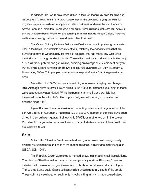
Figure 8 shows the areal distribution according to township/range section of the<br />
614 wells listed in Appendix 2. Note that 432 or about 70 percent of the wells have been<br />
drilled in the southwest quadrant of township 5W/5S, or in other words, in the <strong>Lower</strong><br />
<strong>Pilarcitos</strong> <strong>Creek</strong> groundwater basin. However, as noted above, many of these wells are<br />
not currently in use.<br />
Soils<br />
Soils in the <strong>Pilarcitos</strong> <strong>Creek</strong> watershed and groundwater basin are generally<br />
divided into upland soils and soils of the marine terraces, alluvial fans, and floodplains<br />
(USDA SCS, 1961).<br />
The <strong>Pilarcitos</strong> <strong>Creek</strong> watershed is marked by two major upland soil associations.<br />
The Miramar-Sheridan soil association occurs generally north of <strong>Pilarcitos</strong> <strong>Creek</strong> and<br />
includes soils developed on granitic rocks with shrub- or forest-covered steep slopes.<br />
The Lobitos-Santa Lucia-Gazos soil association occurs generally south of the creek.<br />
These soils are developed on sedimentary rocks with grass- or shrub-covered steep<br />
9
