

Lower Pilarcitos Creek Groundwater Basin Study - Coastside ...
Lower Pilarcitos Creek Groundwater Basin Study - Coastside ...
Lower Pilarcitos Creek Groundwater Basin Study - Coastside ...

Create successful ePaper yourself
Turn your PDF publications into a flip-book with our unique Google optimized e-Paper software.
The bedrock has been affected by folding and faulting but the overlying<br />
unconsolidated formations have experienced only minor deformation (Geoconsultants,<br />
June 1987). Geoconsultants (June 1987) compiled a geologic map of the coastal plain<br />
area between El Granada and Cañada Verde based on Brabb and Pampeyan (1983)<br />
and Lajoie et al. (1974).<br />
Purisima Formation. The <strong>Lower</strong> <strong>Pilarcitos</strong> <strong>Creek</strong> groundwater basin is underlain<br />
by a thick section of Tertiary age Purisima Formation. In 1984, an exploration boring<br />
(5S/5W-30H) drilled by Half Moon Bay Properties near Balboa Boulevard revealed that<br />
the Purisima Formation occurs to depths of at least 1,031 feet (elevation of 1,011 feet<br />
below mean sea level [msl]).<br />
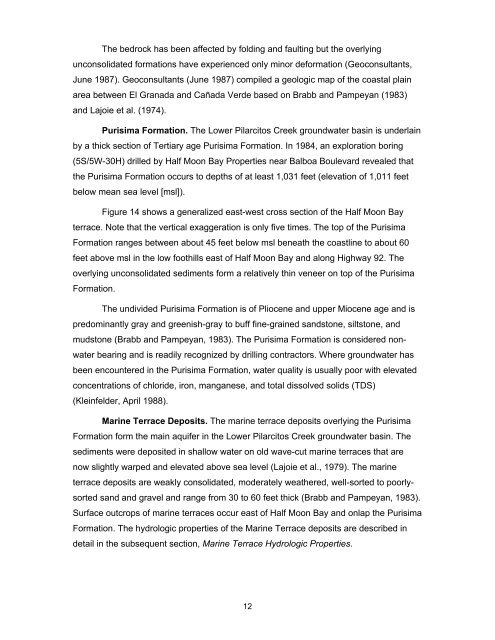
Figure 14 shows a generalized east-west cross section of the Half Moon Bay<br />
terrace. Note that the vertical exaggeration is only five times. The top of the Purisima<br />
Formation ranges between about 45 feet below msl beneath the coastline to about 60<br />
feet above msl in the low foothills east of Half Moon Bay and along Highway 92. The<br />
overlying unconsolidated sediments form a relatively thin veneer on top of the Purisima<br />
Formation.<br />
The undivided Purisima Formation is of Pliocene and upper Miocene age and is<br />
predominantly gray and greenish-gray to buff fine-grained sandstone, siltstone, and<br />
mudstone (Brabb and Pampeyan, 1983). The Purisima Formation is considered nonwater<br />
bearing and is readily recognized by drilling contractors. Where groundwater has<br />
been encountered in the Purisima Formation, water quality is usually poor with elevated<br />
concentrations of chloride, iron, manganese, and total dissolved solids (TDS)<br />
(Kleinfelder, April 1988).<br />
Marine Terrace Deposits. The marine terrace deposits overlying the Purisima<br />
Formation form the main aquifer in the <strong>Lower</strong> <strong>Pilarcitos</strong> <strong>Creek</strong> groundwater basin. The<br />
sediments were deposited in shallow water on old wave-cut marine terraces that are<br />
now slightly warped and elevated above sea level (Lajoie et al., 1979). The marine<br />
terrace deposits are weakly consolidated, moderately weathered, well-sorted to poorlysorted<br />
sand and gravel and range from 30 to 60 feet thick (Brabb and Pampeyan, 1983).<br />
Surface outcrops of marine terraces occur east of Half Moon Bay and onlap the Purisima<br />
Formation. The hydrologic properties of the Marine Terrace deposits are described in<br />
detail in the subsequent section, Marine Terrace Hydrologic Properties.<br />
12
