- Page 1 and 2: u-blox 6 Receiver Description Inclu
- Page 3 and 4: Table of Contents Receiver Descript
- Page 5 and 6: 13.2 Startup Strategies............
- Page 7 and 8: 30.2.1 ALP client requests AlmanacP
- Page 9 and 10: 31.20.1 Poll RXM configuration ....
- Page 11 and 12: 36.1.1 Poll GPS Constellation Alman
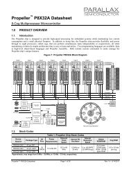
- Page 13 and 14: Receiver Description 1 Overview The
- Page 15: message must be checked. 2.4 Static
- Page 19 and 20: SBAS Configuration parameters conti
- Page 21 and 22: is therefore not configurable on th
- Page 23 and 24: DDC Current Address Read Access 4.3
- Page 25 and 26: NMEA protocol so in most cases, it
- Page 27 and 28: 5.2 Organization of the Configurati
- Page 29 and 30: • Warm start In Warm start mode,
- Page 31 and 32: State machine 9.3.1.1 ON/OFF operat
- Page 33 and 34: has been tracked with a minimal C/N
- Page 35 and 36: 9.3.3 Communication, wake-up, FixNo
- Page 37 and 38: for noon the following day. 9.3.4.2
- Page 39 and 40: • If relative time accuracy betwe
- Page 41 and 42: 11.3.2 Example 2: The following exa
- Page 43 and 44: • RF group delay - delay of the s
- Page 45 and 46: This monitor reports whether jammin
- Page 47 and 48: globe. With A-GPS, the receiver can
- Page 49 and 50: Overview of the different versions
- Page 51 and 52: • If no broadcast ephemeris is av
- Page 53 and 54: any help. Again 12 hours later, how
- Page 55 and 56: 15.2.1 First Byte Reception The eas
- Page 57 and 58: 15.2.3 Latency Depending on the tim
- Page 59 and 60: gyroscope measurement errors. For G
- Page 61 and 62: NMEA Protocol 16 Protocol Overview
- Page 63 and 64: 18 Position Fix Flags in NMEA Mode
- Page 65 and 66: 20 Standard Messages Standard Messa
- Page 67 and 68:
20.3 GGA Message GGA Description Gl
- Page 69 and 70:
20.5 GPQ Message Description GPQ Po
- Page 71 and 72:
20.7 GSA Message Description GSA GN
- Page 73 and 74:
20.9 GSV Message GSV Description GN
- Page 75 and 76:
20.11 TXT Message TXT Description T
- Page 77 and 78:
20.13 ZDA Message ZDA Description T
- Page 79 and 80:
UBX,00 continued Field No. Example
- Page 81 and 82:
Table Satellite Status Satellite St
- Page 83 and 84:
21.4 UBX,05 Message Description Fir
- Page 85 and 86:
21.5 UBX,06 Message Description Fir
- Page 87 and 88:
21.6 UBX Message Description UBX Po
- Page 89 and 90:
21.8 UBX,41 Message UBX,41 Descript
- Page 91 and 92:
UBX Class IDs continued Name Class
- Page 93 and 94:
28 UBX Messages Overview Page Mnemo
- Page 95 and 96:
UBX Messages Overview continued Pag
- Page 97 and 98:
29 ACK (0x05) Ack/Nack Messages: i.
- Page 99 and 100:
30.1.3 GPS Aiding Almanac Input/Out
- Page 101 and 102:
30.2.3 ALP client sends AlmanacPlus
- Page 103 and 104:
AID-ALP continued Byte Offset Byte
- Page 105 and 106:
30.5 AID-DATA (0x0B 0x10) 30.5.1 Po
- Page 107 and 108:
30.7 AID-HUI (0x0B 0x02) 30.7.1 Pol
- Page 109 and 110:
30.8.2 Aiding position, time, frequ
- Page 111 and 112:
31 CFG (0x06) Configuration Input M
- Page 113 and 114:
CFG-CFG continued Byte Offset Numbe
- Page 115 and 116:
CFG-DAT continued Byte Offset Numbe
- Page 117 and 118:
CFG-EKF continued Byte Offset Numbe
- Page 119 and 120:
Bitfield flags This Graphic explain
- Page 121 and 122:
CFG-INF continued Byte Offset Numbe
- Page 123 and 124:
Bitfield config2 This Graphic expla
- Page 125 and 126:
31.10.2 Get/Set Navigation Engine S
- Page 127 and 128:
CFG-NAVX5 continued Byte Offset Num
- Page 129 and 130:
Bitfield filter This Graphic explai
- Page 131 and 132:
31.14 CFG-PM2 (0x06 0x3B) 31.14.1 P
- Page 133 and 134:
31.15 CFG-PM (0x06 0x32) 31.15.1 Po
- Page 135 and 136:
31.16 CFG-PRT (0x06 0x00) 31.16.1 P
- Page 137 and 138:
Bitfield mode This Graphic explains
- Page 139 and 140:
Bitfield txReady Description contin
- Page 141 and 142:
Bitfield mode This Graphic explains
- Page 143 and 144:
Bitfield txReady Description contin
- Page 145 and 146:
31.18 CFG-RINV (0x06 0x34) 31.18.1
- Page 147 and 148:
Bitfield navBbrMask Description con
- Page 149 and 150:
Bitfield mode Description continued
- Page 151 and 152:
CFG-TMODE2 continued Byte Offset Nu
- Page 153 and 154:
31.24.3 Get/Set TimePulse Parameter
- Page 155 and 156:
CFG-TP continued Byte Offset Number
- Page 157 and 158:
32 ESF (0x10) External Sensor Fusio
- Page 159 and 160:
Bitfield sensStatus1 This Graphic e
- Page 161 and 162:
33.3 INF-NOTICE (0x04 0x02) 33.3.1
- Page 163 and 164:
34 MON (0x0A) Monitoring Messages:
- Page 165 and 166:
Bitfield flags This Graphic explain
- Page 167 and 168:
34.4 MON-MSGPP (0x0A 0x06) 34.4.1 M
- Page 169 and 170:
MON-TXBUF continued Byte Offset Num
- Page 171 and 172:
NAV-CLOCK continued Byte Offset Num
- Page 173 and 174:
NAV-EKFSTATUS continued Byte Offset
- Page 175 and 176:
35.7 NAV-POSLLH (0x01 0x02) 35.7.1
- Page 177 and 178:
35.9 NAV-SOL (0x01 0x06) 35.9.1 Nav
- Page 179 and 180:
Bitfield flags This Graphic explain
- Page 181 and 182:
Bitfield flags This Graphic explain
- Page 183 and 184:
NAV-TIMEUTC continued Byte Offset N
- Page 185 and 186:
36 RXM (0x02) Receiver Manager Mess
- Page 187 and 188:
36.2.2 Poll GPS Constellation Ephem
- Page 189 and 190:
RXM-RAW continued Byte Offset Numbe
- Page 191 and 192:
Bitfield age This Graphic explains
- Page 193 and 194:
TIM-TM2 continued Byte Offset Byte
- Page 195 and 196:
37.4 TIM-VRFY (0x0D 0x06) 37.4.1 So
- Page 197 and 198:
• Precise Point Positioning will
- Page 199 and 200:
Dynamic Platform Model Default Sett
- Page 201 and 202:
Power Management 2 Configuration De
- Page 203 and 204:
NMEA default enabled INF msg Messag
- Page 205 and 206:
C Geodetic Datum C.1 Predefined Dat
- Page 207 and 208:
Geodetic Datum Defined in Firmware
- Page 209 and 210:
Geodetic Datum Defined in Firmware
- Page 211 and 212:
Geodetic Datum Defined in Firmware
- Page 213:
Contact For complete contact inform