botchergate - Carlisle City Council
botchergate - Carlisle City Council
botchergate - Carlisle City Council

You also want an ePaper? Increase the reach of your titles
YUMPU automatically turns print PDFs into web optimized ePapers that Google loves.
BOTCHERGATE CONSERVATION AREA APPRAISAL<br />
PART 1 - Character<br />
Appraisal<br />
1.1 Summary of Special Interest<br />
Definition of Botchergate's<br />
Special Interest<br />
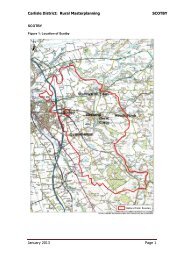
1.1.2 Botchergate Conservation Area is<br />
focused on the linear strip of Botchergate but<br />
expands to encompass the triangular<br />
Woodrouffe Terrace development and also<br />
includes St Nicholas Street as it ascends<br />
towards Currock. It is bounded by Collier<br />
Lane to the northwest, and encompasses Tait<br />
Street and South View Terrace, but more generally<br />
it follows the line of the backs of plots of<br />
development fronting Botchergate (see plan<br />
opposite).<br />
1.1.3 It is characterised by a transition from<br />
mixed residential and modest retail provision<br />
in the southern portion (Area 3), via an area of<br />
currently weak retail in its central portion<br />
(Area 2), through to a more buoyant northern<br />
portion (Area 1). The northern portion of the<br />
Botchergate Conservation Area abuts the <strong>City</strong><br />
Centre Conservation Area and it has historically<br />
aspired to the vibrancy and status of its<br />
northern neighbour.<br />
1.1.4 The special interest of the conservation<br />
area arises from its historic role as a key<br />
approach to the <strong>City</strong> centre. This is seen<br />
physically in its linearity, and also in the intensity<br />
of its uses - with intensity increasing the<br />
closer one progresses northwards. Its historic<br />
role was as a linear route between the gates<br />
of the walled <strong>City</strong> and the south - the most<br />
intensive development was closest to the <strong>City</strong><br />
gates (The Citadel), with a further historic<br />
nucleus at the medieval St Nicholas hospital<br />
site to the south of the current designation.<br />
1.1.5 The physical attributes of the<br />
Conservation Area, which should be preserved<br />
and enhanced, range from the higher<br />
status 19th and early 20thC buildings which<br />
emulate and extend the urban character of<br />
the <strong>City</strong> centre; through the smaller retail offer<br />
of the central section (which now struggles to<br />
find its economic function); and lastly the<br />
areas of residential and mixed use, marking<br />
the transition to the more conventional suburbs<br />
and terraced streets which have gradually<br />
encompassed Botchergate.<br />
1.2 Assessment of Special<br />
Interest<br />
1.2.1 Location and Setting<br />
1.2.2 Historically a suburb outside of the<br />
gates of <strong>Carlisle</strong>, Botchergate has been swallowed<br />
by the southerly expansion of the city.<br />
Until the opening of the M6 motorway in the<br />
1970, it formed the main route between<br />
Glasgow and London and it maintains its historic<br />
function as the primary route into the city<br />
from the south. It remains a key route into the<br />
city and a gateway point at which residential<br />
suburbs can be said to give rise to the urban<br />
core of <strong>Carlisle</strong>.<br />
1.2.3 Originally a linear development on the<br />
approach to the walled city, Botchergate<br />
became increasingly urban and commercial<br />
during the nineteenth century. Firstly narrow<br />
lanes, and later, spur roads were developed<br />
along its length serving new development,<br />
until it became fully enmeshed as the heart of<br />
the web of streets that survive today. The<br />
Conservation Area is urban in character, with<br />
few trees and only a single piece of green<br />
space within its boundaries. Its topography is<br />
largely level and it occupies a plateau in contrast<br />
to land to west, which falls away to what<br />
were once the floodplains of the River Caldew<br />
and its water meadows.<br />
04