botchergate - Carlisle City Council
botchergate - Carlisle City Council
botchergate - Carlisle City Council

Create successful ePaper yourself
Turn your PDF publications into a flip-book with our unique Google optimized e-Paper software.
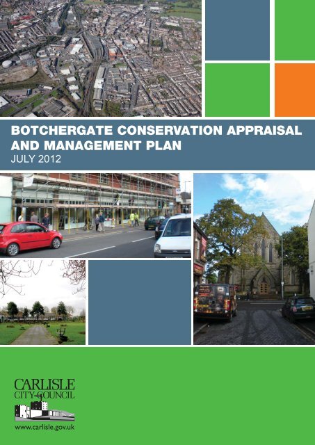
BOTCHERGATE CONSERVATION APPRAISAL<br />
AND MANAGEMENT PLAN<br />
JULY 2012
BOTCHERGATE CONSERVATION AREA APPRAISAL<br />
Contents<br />
Page<br />
Introduction 01<br />
Planning Policy Context 01<br />
PART 1 - Character Appraisal 04<br />
Summary of Special Interest 04<br />
Definition of Botchergate's Special Interest 04<br />
Assessment of Special Interest 04<br />
Location and Setting 04<br />
Character Areas 06<br />
Historic Development and Archaeology 08<br />
Economic Regeneration 11<br />
Spatial Analysis 12<br />
Key Views and Vistas 13<br />
Character Analysis (by areas) 14<br />
Area One (northern portion of conservation area) 14<br />
Area Two (central portion of conservation area) 15<br />
Area Three (southern portion of conservation area) 17<br />
Public Realm 19<br />
Green Infrastructure 20<br />
Extent of Intrusion or Damage (negative factors) 20<br />
Neutral Areas 21<br />
PART 2 - Management Plan 22<br />
Conservation Area Boundary Review 22<br />
Public Realm 24<br />
Protection of Historic Fabric 24<br />
Article 4 Directives 25<br />
Development Opportunities 26<br />
SWOT Analysis (Strengths, Weaknesses,<br />
Opportunities and Threats) 29<br />
Implementation Matrix 30<br />
Bibliography 31
BOTCHERGATE CONSERVATION AREA APPRAISAL<br />
Fig 01. A view across Christ Church Gardens - former site of the demolished Christ Church. To the left of the image is the<br />
‘Crown Works’ warehouse and to the right, Stanley Hall.<br />
i. Introduction<br />
ii. Botchergate Conservation Area was<br />
designated in January 1994. The designation<br />
was preceded by work by the <strong>Carlisle</strong> and<br />
District Civic Trust, the <strong>City</strong> <strong>Council</strong>, and others<br />
who had pressed for the designation in<br />
order to protect the special architectural character<br />
of Botchergate and resist threats to it<br />
arising from unsympathetic redevelopment or<br />
neglect.<br />
iii. One of the primary threats to the conservation<br />
area was the neglect, decay and<br />
loss of its historic fabric through the weak and<br />
declining economic position that Botchergate<br />
then occupied. While subsequent years have<br />
seen significant investments in parts of the<br />
conservation area, much of Botchergate still<br />
lacks the economic robustness that would<br />
provide a solid foundation for improvement<br />
and protection of those elements of quality<br />
within the area which remain.<br />
iv. This document is in two parts. The first<br />
part is a character appraisal of the<br />
Botchergate Conservation Area. The second<br />
part is a management plan which puts forward<br />
proposals that will enhance and preserve the<br />
character and appearance of the conservation<br />
area. It identifies those sites and buildings<br />
that may be the subject of development<br />
proposals and it expands on how <strong>Carlisle</strong><br />
District Local Plan Policy LE19 should be<br />
interpreted in this conservation area.<br />
v. Planning Policy Context<br />
vi. The Planning (Listed Buildings and<br />
Conservation Areas) Act 1990 imposes a duty<br />
on Local Authorities to designate as conservation<br />
areas any "areas of special architectural<br />
or historic interest, the character or appearance<br />
of which it is desirable to preserve or<br />
enhance". The Act emphasises that the<br />
appraisal and designation of conservation<br />
areas are not to be considered ends in them-<br />
Fig 02. Botchergate has a legacy of both grand and modest<br />
commercial buildings, but with many marred by poor quality<br />
alterations.<br />
Fig 03. An incongruous 1960s structure, with significant<br />
potential for redevelopment.<br />
01
BOTCHERGATE CONSERVATION AREA APPRAISAL<br />
selves. It places a duty on local authorities to<br />
draw up and publish proposals for the preservation<br />
and enhancement of conservation<br />
areas in their districts, and to consult the local<br />
community about these proposals.<br />
vii. Regional Planning Guidance for the<br />
North West (2003) has as one of its Core<br />
Development Principles Policy DP2<br />
'Enhancing the Quality of Life'. This includes<br />
the need to identify important elements of<br />
environmental, social and economic 'capital'<br />
so that Development Plans can introduce policies<br />
which set out clearly those elements of<br />
'capital' where there is a presumption against<br />
any harm arising from development. Where<br />
possible these policies should enhance the<br />
quality of life.<br />
viii. At County level the Cumbria and Lake<br />
District Joint Structure Plan (2005) Policy E34<br />
states that "measures will be taken to identify,<br />
record, protect, conserve or enhance areas,<br />
sites, buildings and settings or archeological,<br />
historic and architectural importance.<br />
Proposals which fail to preserve or enhance<br />
the character or appearance of Conservation<br />
areas… will not be permitted unless the harm<br />
caused to their importance and intrinsic interest<br />
is clearly outweighed by the need for the<br />
development". Policy E35 supports development<br />
which "includes measures to regenerate<br />
and upgrade rural, urban and urban fringe<br />
environments, both built and natural".<br />
ix. The <strong>Carlisle</strong> District Local Plan<br />
(September 2008) has several policies relating<br />
to Conservation Areas, the most important<br />
being LE19 -<br />
“LE19 Conservation Areas<br />
The <strong>City</strong> <strong>Council</strong> will continue to review existing<br />
and designate new conservation areas.<br />
Development proposals within and adjoining<br />
conservation areas will be granted planning<br />
permission provided they preserve or<br />
enhance their character and appearance. Any<br />
new development or alterations to existing<br />
buildings should harmonise with their surroundings<br />
and be in sympathy with the setting,<br />
scale, density and physical characteristics<br />
of conservation areas, and protect important<br />
views into or out of such areas.<br />
Applications for outline planning permission<br />
will not be accepted for proposals in conservation<br />
areas. Proposals for new development<br />
and/or alterations to buildings in conservation<br />
areas will be judged against the following criteria:<br />
1. the development should preserve or<br />
enhance all features which contribute positively<br />
to the area's character or appearance,<br />
in particular the design, massing and height of<br />
the building should closely relate to adjacent<br />
buildings and should not have an unacceptable<br />
impact on the townscape or landscape;<br />
2. the development should not have an<br />
unacceptable impact on the historic street<br />
patterns and morphology, roofscape, skyline<br />
and setting of the conservation area, important<br />
open spaces or significant views into, out<br />
of and within the area;<br />
3. development proposals should not<br />
result in the amalgamation or redrawing of<br />
boundaries between traditional buildings and<br />
plots, or demolition and redevelopment<br />
behind retained facades;<br />
4. wherever practicable traditional local<br />
materials such as brick, stone and slate<br />
should be used and incongruous materials<br />
should be avoided;<br />
5. individual features both on buildings<br />
02
BOTCHERGATE CONSERVATION AREA APPRAISAL<br />
and contributing to their setting, should be<br />
retained e.g. doorways, windows, shopfronts,<br />
garden walls, railings, cobbled or flagged<br />
forecourts, sandstone kerbs, trees and<br />
hedges, etc. Where features have deteriorated<br />
to the extent to which they have to be<br />
replaced, the replacement should match the<br />
original;<br />
6. proposals which would generate a significant<br />
increase in traffic movements and<br />
heavy vehicles or excessive parking demands<br />
will not be permitted since these would be<br />
prejudicial to amenity;<br />
7. proposals which would require substantial<br />
car parking and servicing areas which<br />
can not be provided without an adverse effect<br />
on the site and its surroundings will not be<br />
permitted”.<br />
the Plan period the <strong>Council</strong> will actively seek<br />
to reduce the number of Buildings at Risk on<br />
the national or local registers by assisting with<br />
proposals for their re-use which are sympathetic<br />
to their historic character and setting. In<br />
addition the <strong>Council</strong> will prepare a local list of<br />
buildings which are important for their historic,<br />
architectural design or location. Proposals for<br />
the demolition of locally listed buildings will be<br />
resisted in order to maintain the contribution<br />
they make to the local environment.<br />
xiii. POLICY LE21 Townscape<br />
Improvement Areas Within <strong>Carlisle</strong>'s the <strong>City</strong><br />
Centre, Botchergate, Brampton and<br />
Longtown Conservation Areas, the <strong>City</strong><br />
<strong>Council</strong> will encourage the redevelopment or<br />
improvement of buildings identified as<br />
frontage improvement areas.<br />
x. The direction given by this policy forms<br />
the core of development guidance for the<br />
Botchergate Conservation Area. The<br />
Conservation Area Appraisal, the<br />
Management Plan and detailed development<br />
briefs, where appropriate, will give more specific<br />
guidance as to matters of detail.<br />
xi. Policy LE16 Historic Structures and<br />
Local Listings is significant in an area with a<br />
high proportion of nineteenth century buildings<br />
that retain considerable architectural,<br />
historical or townscape character.<br />
xii. Policy LE17 Development Involving<br />
the Demolition of Unlisted Buildings in<br />
Conservation Areas provides a general presumption<br />
in favour of retaining buildings,<br />
which make a positive contribution to the<br />
character or appearance of the Conservation<br />
Area.<br />
xiii.<br />
Policy LE18 Buildings at Risk During<br />
03
BOTCHERGATE CONSERVATION AREA APPRAISAL<br />
PART 1 - Character<br />
Appraisal<br />
1.1 Summary of Special Interest<br />
Definition of Botchergate's<br />
Special Interest<br />
1.1.2 Botchergate Conservation Area is<br />
focused on the linear strip of Botchergate but<br />
expands to encompass the triangular<br />
Woodrouffe Terrace development and also<br />
includes St Nicholas Street as it ascends<br />
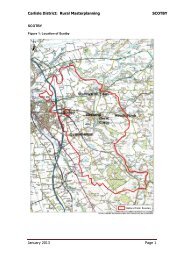
towards Currock. It is bounded by Collier<br />
Lane to the northwest, and encompasses Tait<br />
Street and South View Terrace, but more generally<br />
it follows the line of the backs of plots of<br />
development fronting Botchergate (see plan<br />
opposite).<br />
1.1.3 It is characterised by a transition from<br />
mixed residential and modest retail provision<br />
in the southern portion (Area 3), via an area of<br />
currently weak retail in its central portion<br />
(Area 2), through to a more buoyant northern<br />
portion (Area 1). The northern portion of the<br />
Botchergate Conservation Area abuts the <strong>City</strong><br />
Centre Conservation Area and it has historically<br />
aspired to the vibrancy and status of its<br />
northern neighbour.<br />
1.1.4 The special interest of the conservation<br />
area arises from its historic role as a key<br />
approach to the <strong>City</strong> centre. This is seen<br />
physically in its linearity, and also in the intensity<br />
of its uses - with intensity increasing the<br />
closer one progresses northwards. Its historic<br />
role was as a linear route between the gates<br />
of the walled <strong>City</strong> and the south - the most<br />
intensive development was closest to the <strong>City</strong><br />
gates (The Citadel), with a further historic<br />
nucleus at the medieval St Nicholas hospital<br />
site to the south of the current designation.<br />
1.1.5 The physical attributes of the<br />
Conservation Area, which should be preserved<br />
and enhanced, range from the higher<br />
status 19th and early 20thC buildings which<br />
emulate and extend the urban character of<br />
the <strong>City</strong> centre; through the smaller retail offer<br />
of the central section (which now struggles to<br />
find its economic function); and lastly the<br />
areas of residential and mixed use, marking<br />
the transition to the more conventional suburbs<br />
and terraced streets which have gradually<br />
encompassed Botchergate.<br />
1.2 Assessment of Special<br />
Interest<br />
1.2.1 Location and Setting<br />
1.2.2 Historically a suburb outside of the<br />
gates of <strong>Carlisle</strong>, Botchergate has been swallowed<br />
by the southerly expansion of the city.<br />
Until the opening of the M6 motorway in the<br />
1970, it formed the main route between<br />
Glasgow and London and it maintains its historic<br />
function as the primary route into the city<br />
from the south. It remains a key route into the<br />
city and a gateway point at which residential<br />
suburbs can be said to give rise to the urban<br />
core of <strong>Carlisle</strong>.<br />
1.2.3 Originally a linear development on the<br />
approach to the walled city, Botchergate<br />
became increasingly urban and commercial<br />
during the nineteenth century. Firstly narrow<br />
lanes, and later, spur roads were developed<br />
along its length serving new development,<br />
until it became fully enmeshed as the heart of<br />
the web of streets that survive today. The<br />
Conservation Area is urban in character, with<br />
few trees and only a single piece of green<br />
space within its boundaries. Its topography is<br />
largely level and it occupies a plateau in contrast<br />
to land to west, which falls away to what<br />
were once the floodplains of the River Caldew<br />
and its water meadows.<br />
04
BOTCHERGATE CONSERVATION AREA APPRAISAL<br />
Chatsworth Square/<br />
Portland Square<br />
Conservation Area<br />
<strong>City</strong> Centre<br />
Conservation Area<br />
Botchergate<br />
Conservation Area<br />
Settle to <strong>Carlisle</strong><br />
Conservation Area<br />
05
BOTCHERGATE CONSERVATION AREA APPRAISAL<br />
1.3 Character Areas<br />
1.3.1 For the purposes of this appraisal<br />
Botchergate can be said to comprise three<br />
character areas (illustrated by figures 3, 6 and<br />
7 and named areas 'One', 'Two' and 'Three').<br />
Area 1<br />
1.3.2 Area One comprises the part closest to<br />
the Citadel at Botchergate's northern tip. This<br />
area is the most urban in character and scale,<br />
reflecting its proximity to the railways station<br />
and the commercial heart of <strong>Carlisle</strong>. From<br />
the Victorian period it has been characterised<br />
by buildings of some scale and grandeur.<br />
Though less grand than the architecture<br />
which occupies the adjacent Crescent area<br />
(<strong>City</strong> Centre Conservation Area) it has nevertheless<br />
aspired to a similar status. Area One<br />
has hosted Botchergate's more recent commercial<br />
redevelopments, largely focused on<br />
the evening economy and entertainment, and<br />
while there has been significant clearance<br />
and reconstruction, there has also been<br />
investment in the maintenance of the building<br />
stock.<br />
Listed Buildings<br />
Local List Buildings<br />
Potential new Local List Buildings<br />
Townscape Improvement Areas<br />
Focal Areas for frontage improvement<br />
Neutral impact areas<br />
Fig 03. The northern portion of the Botchergate Conservation<br />
Area is identified as ‘Area 1’.<br />
Area 2<br />
1.3.3 Area Two runs from Tait Street to<br />
Rydal Street. It has less grandeur than Area<br />
One and the parts fronting Botchergate are<br />
commercial in character. This section has suffered<br />
significantly from a decline in local<br />
shopping and by changing retail patterns and<br />
this is evidenced by the neglected state of<br />
many of the buildings. The housing that previously<br />
abutted the western flank of this section<br />
was cleared in the 1960's and this has<br />
reduced the population necessary to support<br />
buoyant commerce. By contrast Tait Street<br />
has survived as a well-preserved residential<br />
street of polite terraced housing and is now<br />
Grade II listed.<br />
06<br />
Fig 04. ‘Area 1’ - The northern extremity of Botchergate - the<br />
large white building marks the beginning of the adjacent ‘<strong>City</strong><br />
Centre Conservation Area’.<br />
Fig 05. Tait Street, a heavily trafficked residential side-street<br />
to Botchergate within ‘Area 2’.
BOTCHERGATE CONSERVATION AREA APPRAISAL<br />
Listed Buildings<br />
Local List Buildings<br />
Potential new Local List Buildings<br />
Townscape Improvement Areas<br />
Focal Areas for frontage improvement<br />
Neutral impact areas<br />
Listed Buildings<br />
Local List Buildings<br />
Potential new Local List Buildings<br />
Townscape Improvement Areas<br />
Focal Areas for frontage improvement<br />
Neutral impact areas<br />
Fig 06. Area 2 Fig 07. Area 3<br />
Area 3<br />
1.3.3 Area Three runs from Rydal Street<br />
southwards, and encompasses both part of<br />
London Road and also St Nicholas Street/St<br />
Nicholas Bridges. The area is fragmentary in<br />
character and while the Grade II listed workers<br />
housing at Woodrouffe Terrace and St<br />
Nicholas Street provide a ballast of quality,<br />
much of the frontage commercial units are in<br />
a poor state.<br />
Fig 08. The 1905 Stanley Hall - a prominent Edwardian building<br />
in ‘Area 2’ (prior to refurbishment)<br />
1.3.4 This is exacerbated by sites such as<br />
12-18 St Nicholas Street whose contribution<br />
to the streetscape, vitality and attractiveness<br />
of the area is negative, but which lie outside<br />
the Conservation Area boundary.<br />
Fig 09. The four storey rendered building marks the beginning<br />
of London Road and ‘Area 3’<br />
07
BOTCHERGATE CONSERVATION AREA APPRAISAL<br />
Fig 10. Smith’s 1746 map showing Botchergate and the road ‘to London’ to the bottom right of the frame. Towill 1996 p26<br />
1.4 Historic Development and<br />
Archaeology<br />
1.4.1 Botchergate, previously ‘Botchardgate’,<br />
was originally a township forming the<br />
southern approach to <strong>Carlisle</strong>, and owned<br />
around the time of Henry I by one 'Botchard',<br />
a native of Flanders (1). G Smith's 1746 map<br />
of <strong>Carlisle</strong> shows Botchergate as the principal<br />
route south and framed by linear development<br />
(Figure 10). The character of existing development<br />
to the northern part of Botchergate<br />
reflects and continues a historic quirk, as<br />
hostelries and victuallers sprang up outside<br />
the gates of the <strong>City</strong>, closed after dark by an<br />
ordinance of Elizabeth 1st and barring entry<br />
to travellers. 400 years on, this function still<br />
serves many buildings on the northern part of<br />
Botchergate.<br />
1.4.2 Early development appears to have<br />
concentrated at its northern end, closest to<br />
the entrance to the walled city, and tailed off<br />
towards the south. An early occupant of the<br />
southern extremity of Botchergate was the<br />
medieval St Nicholas leper hospital, indicating<br />
the peripheral nature of this area. The hospital<br />
occupied the site (just south of South<br />
Street) until its sacking during the Civil War.<br />
<strong>Carlisle</strong>'s gradual expansion during the 18th<br />
and nineteenth centuries saw the linear strip<br />
of Botchergate develop adjoining streets of<br />
working class housing, interspersed with the<br />
industrial enterprises these residents served.<br />
The mixed residential and commercial nature<br />
of the main street became increasingly commercial,<br />
with an eclectic range of public houses,<br />
hotels, manufacturing, entertainment and<br />
retailers present. The proximity to <strong>Carlisle</strong><br />
Citadel Station will have stimulated this<br />
growth, and in particular that of the grander<br />
08
BOTCHERGATE CONSERVATION AREA APPRAISAL<br />
Fig 11. Extract from 1821 Woods Map of <strong>Carlisle</strong> clearly showing the linear development that was creeping along Botchergate,<br />
with additional development occurring at 90degrees to the main street. Towill 1996 p52.<br />
hotels which developed at the northern<br />
extremity.<br />
1.4.3 The 1821 Wood's map shows the linear<br />
nature of Botchergate indicating frontage<br />
development with occasional backland buildings<br />
(Figure 11) . At its northern end the mews<br />
buildings of what is now Collier Lane can be<br />
seen to have been developed, with spurs of<br />
buildings perpendicular to the main street in<br />
what is now the vicinity of Tait Street and<br />
Portland Place.<br />
1.4.4 By the 1860's good quality terraced<br />
housing had struck out along the newly<br />
formed Tait Street. Union Street (now Rydal<br />
Street), had begun to be lined with terraces<br />
but South Street, Charles Street and Close<br />
Street had just been laid out (Fig 12).<br />
1.4.5 The 1900 map (overleaf) shows the<br />
Fig 12. 1869 Map of Botchergate<br />
09
BOTCHERGATE CONSERVATION AREA APPRAISAL<br />
development of Botchergate and its hinterland<br />
perhaps at the height of its urbanisation,<br />
with each side of the street densely lined with<br />
terraces interspersed with business and manufacturers.<br />
The narrow 'burgage' plots which<br />
characterised ownerships on the 1821 map<br />
have influenced the development of later<br />
stages. These patterns can be seen to have<br />
dictated the shapes of developments such as<br />
the Rickerby's agricultural works at the rear of<br />
Portland Place (now a surface car park), and<br />
also the numerous narrow lanes and courts<br />
that stretched back from the frontage, lined<br />
with dense housing and workshops of which<br />
there is now little trace.<br />
1.4.6 As the twentieth century progressed<br />
there has been a tendency for developments<br />
which have consolidated and obliterated<br />
these traces of early land ownerships, with<br />
large swathes of backland now coalesced into<br />
areas of car parking or large footprint buildings.<br />
The frontages have proved more robust,<br />
and while a number of buildings which span<br />
numerous original plot widths (e.g. Stanley<br />
Hall and Palace Arcade) the ground floor subdivisions<br />
broadly reflect the 4-5m footprints of<br />
earlier plots. Towards the southern part of the<br />
street unconsolidated smaller frontages are<br />
very much still in evidence.<br />
Fig 13 - Botchergate at the peak of its urbanisation in 1901.<br />
1.4.6 The area is architecturally notable<br />
thanks to the legacy of Victorian/Edwardian<br />
commercial confidence, evident in surviving<br />
buildings such as the Stanley Hall and the<br />
Palace Arcade and in some of the ornament<br />
and confidence that can be seen in neighbouring<br />
buildings. Two notable places of worship<br />
arose in this same period of civic confidence<br />
- the 1830 Christ Church (Demolished<br />
in 1952) and in Area 3, the imposing church of<br />
St John's on London Road. The Christ Church<br />
site is now occupied by the underutilised<br />
Christ Church gardens, providing the sole<br />
10<br />
Fig 14. Botchergate remained largely intact until the mid<br />
1970’s when the terraces of King Street, Princess St and<br />
Lord St were cleared.
BOTCHERGATE CONSERVATION AREA APPRAISAL<br />
area of green open space within the<br />
Conservation Area.<br />
1.4.7 The peak of development on<br />
Botchergate is illustrated by the 1901 map (fig<br />
13). By the 1970s large areas of terraced<br />
housing were cleared under the auspices of<br />
slum clearance. It is likely that this resulted in<br />
a gradual depopulation of the area which contributed<br />
to a decline in the fortunes of<br />
Botchergate. This depopulation was coupled<br />
with the changes in shopping patterns and the<br />
decline of the traditional high street common<br />
to the latter half of the 20th Century. Notable<br />
survivors of these residential clearances<br />
include the Grade II listed Woodrouffe<br />
Terrace, St Nicholas Street and Tait Street.<br />
These are characterised by modest but wellbuilt<br />
domestic architecture, and a rhythm and<br />
repetition of building elements such as wellproportioned<br />
window openings, architraving,<br />
chimney stacks and doorways which their<br />
Listing serves to protect (Fig 16 and 17).<br />
1.4.8 Archeological interest may be present<br />
throughout the area. Previous archeological<br />
work provides no more than glimpses of the<br />
likely archeological potential. The area was<br />
utilised in the Roman period, including for burial.<br />
The medieval leper hospital of St Nicholas<br />
is also a likely focus of potential interest.<br />
Before the approval of any planning consent it<br />
is likely that an archeological evaluation<br />
should be undertaken (Cumbria county<br />
<strong>Council</strong> 2006).<br />
Fig 15. Showing the loss of housing to the southwest of the<br />
Conservation Area boundary and replacement with industrial<br />
units.<br />
Fig 16. The former public house at the corner of Woodrouffe<br />
Terrace and St Nicholas Street.<br />
1.5 Economic Regeneration<br />
1.5.1 Efforts to revive the area gained<br />
momentum in the 1990's culminating with the<br />
creation in 2003 of the English Gate Plaza<br />
scheme. This involved the demolition of<br />
almost 150m of existing frontage buildings<br />
Fig 17. The Grade II listed Woodrouffe Terrace.<br />
11
BOTCHERGATE CONSERVATION AREA APPRAISAL<br />
and their replacement with a mixed use development<br />
comprising office, retail, residential<br />
and entertainment space. Commercially<br />
largely successful, this scheme and associated<br />
investment to the northern part of the<br />
Conservation area have led to investment in<br />
the fabric of those historic buildings which<br />
remain. This built on earlier restoration works<br />
started in 1994 under the Conservation Area<br />
Partnership (CAP) Scheme and <strong>City</strong> <strong>Council</strong><br />
grants. Between 1994 and 1997 some<br />
£900,000 was invested in the Botchergate<br />
area by English Heritage, the <strong>City</strong> <strong>Council</strong>,<br />
Housing Associations and the private sector<br />
(CAP bid 1997). This included a 'Group<br />
Repair Scheme' for the listed buildings on St<br />
Nicholas Street.<br />
1.5.2 While the achievements made by<br />
these investments must be recognised, it is<br />
fair to say that a significant portion of the conservation<br />
area is currently in a poor state of<br />
repair and is suffering the twin perils of neglect<br />
and unsympathetic 'improvement'. The<br />
parlous state of many of the buildings within<br />
the Conservation Area, and their neglect or<br />
unsympathetic alteration, is worsened by the<br />
general decline in the retail strength of the<br />
'traditional high street' in the face of <strong>City</strong><br />
Centre or supermarket competition, and by<br />
the changed character of its hinterland - the<br />
dense population that once abutted western<br />
Botchergate has been cleared to make way<br />
for low density light industry which contributes<br />
little to the economic vitality of the high street.<br />
Opportunities to reinvent Lancaster Street<br />
and its environs as a residential-led mixed<br />
use area may help to provide the resident<br />
population and vibrancy that the Conservation<br />
Area needs if it is to regain some of its former<br />
vigour.<br />
Fig 18. St John’s Church on London Road is one of the more<br />
notable buildings at the southern end of the Conservation<br />
area.<br />
Fig 19. A prominent building at 1 London Road, which has<br />
recently has render applied over its original brickwork<br />
1.6 Spatial Analysis<br />
1.6.1 There is an evident building hierarchy<br />
on approaching the conservation area from<br />
the south. Within Area Three, (with the exception<br />
of St John's Church - fig 18), buildings are<br />
largely two storey and domestic in scale. Few<br />
'statement buildings' are evident within this<br />
area, perhaps with the exception of the corner<br />
12
BOTCHERGATE CONSERVATION AREA APPRAISAL<br />
building to South Street/London Road, recently<br />
the subject of unsympathetic modifications<br />
(fig 19). Building heights and commercial<br />
stature rise a little as one enters Area Two,<br />
with notable substantial buildings being the<br />
Stanley Hall and Palace Arcade. In Area One<br />
surviving Victorian buildings have aspired to<br />
some architectural sophistication, and the<br />
general impression is of a mature urban<br />
street. The 4-6m plot dimensions that is typical<br />
of the length of Botchergate is largely<br />
respected in Area One, despite the amalgamation<br />
of plot boundaries - the echoes of earlier<br />
plot widths can be seen in the subdivisions<br />
at ground level despite coalescence of<br />
ownership. As building heights rise in Area<br />
One, this pleasant rhythm of narrow plots and<br />
vertically emphasised buildings lends a distinctive<br />
quality to the street. The rise in building<br />
heights relative to street width in Area One<br />
generates a greater sense of enclosure that is<br />
absent in Area Three and only emerging in<br />
Area Two.<br />
Fig 20. Open space at Christ church Gardens.<br />
Fig 21. The vehicle dominated junction of St Nicholas Street<br />
and London Road.<br />
1.6.2 Two areas of 'openness' are evident.<br />
These are Christ Church gardens in Area Two<br />
and the nodal 'open space' generated by the<br />
junction of St Nicholas Road and the<br />
Botchergate/London Road interface. Although<br />
traffic dominated and austere, this junction is<br />
a potentially important space within the conservation<br />
area and one whose potential is as<br />
yet untapped. Christ Church gardens occupy<br />
the former Christ Church site. This genuinely<br />
green open space is significantly undercapitalised,<br />
with no buildings presenting active<br />
frontage to it, no through routes and little animation.<br />
1.7 Key Views and Vistas<br />
1.7.1 The linearity of the conservation area<br />
means that while there are a series of long<br />
distance views towards landmarks including<br />
Fig 22. The long vista northwards up Botchergate towards<br />
the Citadel.<br />
the tower of <strong>Carlisle</strong> Cathedral, the Citadel<br />
and some prominent corner buildings along<br />
Botchergate, it is unlikely that development<br />
will significantly impede these views. The<br />
street itself creates a largely unbroken sense<br />
of enclosure and where streets open up off<br />
the main thoroughfare, or in the occasional<br />
break in the frontage, no critical landmarks or<br />
vistas are evident. It may be that the biggest<br />
opportunity sites to create new vistas are<br />
13
BOTCHERGATE CONSERVATION AREA APPRAISAL<br />
Christ Church gardens and the St Nicholas St<br />
junction referred to above. At present these<br />
areas are underwhelming but an appropriate<br />
landscape / architectural intervention could<br />
create focal points and vistas of note.<br />
1.7.2 A recent example of a missed opportunity<br />
to utilise a vista to the mutual benefit of<br />
both the streetscape and the development is<br />
the interface between the recent 'picture<br />
house apartments' and the large carriage arch<br />
set within the Palace Arcade. The new building<br />
nudges apologetically into view through<br />
the arch when it could have been designed as<br />
a complimentary element (fig 23).<br />
Fig 23. New apartments seen through the arch of the Palace<br />
Arcade.<br />
1.8 Character Analysis (by areas)<br />
1.8.1 Area One (northern portion of<br />
conservation area)<br />
1.8.2 Area One contains the conservation<br />
area’s greatest concentration of good quality<br />
commercial Victorian/Edwardian architecture.<br />
The entire frontage, except for the recent<br />
developments at English Gate, and the unfortunate<br />
(c1962) 30-34 Botchergate (fig 26), are<br />
locally listed, with Harry Redfern's<br />
Cumberland Inn Grade II listed. The 2000-<br />
2003 English Gate Plaza and Ibis hotel development<br />
attempt to replicate the scale and<br />
rhythm of their Victorian neighbours but are<br />
markedly more austere and lack visual richness.<br />
They benefit the Conservation Area<br />
however in that they have helped to inject<br />
new uses into what was a series of vacant<br />
and increasingly decaying buildings, spurring<br />
investment in their retained neighbours.<br />
Design failings within the scheme include the<br />
blank elevations that frame the new incidental<br />
open space of English Gate Plaza, and the<br />
barren car parking behind the new scheme. It<br />
is testament to the visual strength of the<br />
Fig 24. Area One<br />
remaining architecture that such a substantial<br />
modern development can be accommodated<br />
without significant detriment to the character<br />
of the street.<br />
1.8.3 The traditional architecture in the area<br />
is diverse and in many cases exuberant. It is<br />
evident that there was a degree of competition<br />
between Botchergate's Victorian develop-<br />
14
BOTCHERGATE CONSERVATION AREA APPRAISAL<br />
ers to outdo their neighbours. A common<br />
thread however is a strong vertical emphasis,<br />
with windows, mullions, columns, pilasters<br />
and chimney stacks contributing to this effect.<br />
The vulnerability of these buildings is greatest<br />
at ground level, where unsympathetic retail<br />
signage and frontages can mar elevations. A<br />
further source of more fundamental damage<br />
is through the neglect of maintenance of the<br />
wider building that can bring about structural<br />
damage. Fig 25 shows rampant vegetation in<br />
the gutters of the Boustead's Building which<br />
will almost certainly result in water ingress<br />
and costly damage if left unchecked.<br />
Cosmetic changes at ground level can at<br />
least be remedied - as evidenced by the<br />
achievements of the CAP scheme - whereas<br />
structural damage arising through neglect<br />
may have more insidious impacts.<br />
Fig25. Neglect of basic maintenance in the former<br />
Boustead’s building, latterly Mood’s Nightclub.<br />
1.8.4 The building line is almost without<br />
exception on Botchergate hard-up to the back<br />
of the pavement. This reflects the intensity of<br />
the commercial uses here that dictated that<br />
each plot and building should work as hard as<br />
possible to make its presence known. The<br />
narrow plot widths and frequency of doorways<br />
onto the street helps to generate vitality.<br />
Fig 26. An unfortunate 1960s insertion into the otherwise<br />
impressive buildings of the northern part of Botchergate.<br />
1.8.5 Area Two (central portion of conservation<br />
area)<br />
1.8.6 The central part of the Conservation<br />
Area is at present the most vulnerable and<br />
economically weak. This places its buildings<br />
at risk, as lower quality interventions may be<br />
considered by owners to be acceptable<br />
options. A notable negative influence on the<br />
appearance of this area arises from the unimplemented<br />
planning consents for comprehensive<br />
redevelopment applying to the buildings<br />
between South Henry Street and Rydal Street<br />
(fig 29). Notwithstanding this permission the<br />
buildings themselves are of some modest<br />
Fig 27. Area Two<br />
15
BOTCHERGATE CONSERVATION AREA APPRAISAL<br />
architectural interest, in particular the low two<br />
storey building at 149/151 Botchergate, (fig<br />
26) - in part as a result of benign neglect its<br />
shop front has been retained. This block could<br />
be revived sympathetically and allowed once<br />
again to contribute to the quality of the street<br />
if the currently proposed demolition and comprehensive<br />
redevelopment were not to be<br />
enacted.<br />
1.8.7 Adjacent to this block is the much<br />
grander Stanley Hall (119-147 Botchergate).<br />
Subject to a 1990's 'Living Over the Shop' initiative<br />
the building was originally built as retail<br />
with offices above, fronting the livestock market.<br />
The incremental loss of building elements<br />
to this grand (though unlisted) 1905 building<br />
can be seen here in the truncated chimney<br />
stack to the northern gable. A marked improvment<br />
has however been achieved by recent<br />
refurbishment work to the building, and to a<br />
unified approach to the colour and design of<br />
the ground floor.<br />
1.8.8 Opposite this building is the Palace<br />
Arcade. The building shows a broadly successful<br />
approach to its shop frontage in the<br />
northern portion, (fig 33) where the 'Gary<br />
Etherbridge' unit spans three bays but in subtle<br />
and attractive manner. The southern<br />
'palace cycles' signage is much more dominant<br />
and unnecessarily large. Neither occupier<br />
benefits aesthetically from the security<br />
shutters which could be located more sensitively<br />
behind the glazing. The Palace Arcade<br />
shows examples of the incremental loss of<br />
architectural detail - in this case the missing<br />
pediment from the central gable, which throws<br />
the composition of the facade out of balance.<br />
With funding this could be reinstated.<br />
Fig 29. An unimplemented permission exists for this block<br />
between Rydal and South Henry Street.<br />
Fig 30. Truncated chimney<br />
stack to the Stanley Hall.<br />
Fig 31. The site of the first<br />
mainland UK post box, installed<br />
in 1853 on Botchergate.<br />
Fig 32. Great improvments to the appearance of Stanley Hall<br />
were made by McKnight’s builders in 2011.<br />
1.8.9 The northern portion of the Palace<br />
building was improved under the Botchergate<br />
Conservation Area Partnership scheme in<br />
1994/1997 but the building is again showing<br />
16<br />
Fig 33. The Palace Arcade building - sadly missing a pediment<br />
previously located over the central arch.
BOTCHERGATE CONSERVATION AREA APPRAISAL<br />
some signs of deterioration. It is unfortunate<br />
that the 'Picture House' residential development<br />
to the rear did not make more use of the<br />
arcade entrance, and indeed the adjacent<br />
Christ Church park.<br />
1.8.10 An exception to the relative decay evident<br />
in the central portion of the Conservation<br />
Area is the residential umbilical of Tait Street<br />
(fig 34). These polite mid-Victorian dwellings<br />
are Grade II listed and retain the repeating<br />
elements of sash windows, panelled doors,<br />
and detailing which lends coherence to terraces.<br />
As a main traffic artery (in particular<br />
when Botchergate is partially closed on Friday<br />
and Saturday nights) the environmental quality<br />
of the street is somewhat compromised.<br />
The quality of the street is added to by its<br />
avenue tree planting, and where necessary<br />
these trees should be sensitively managed<br />
and replaced as specimens are lost. Any<br />
reduction, or sensitive calming, of traffic<br />
would enhance the quality of the street.<br />
Fig 34. The Grade II listed residential terraces of Tait Street,<br />
enhanced by legacy of Victorian tree planting.<br />
1.8.11 Area Three<br />
1.8.12 This area stretches from Rydal Street<br />
and through to St Nicholas Bridge. It encompasses<br />
the confluence of 'Botchergate' as it<br />
becomes 'London Road', and ends at the twin<br />
listed public houses of The Cranemakers and<br />
The St Nicholas Arms. The area is varied in<br />
quality, though significantly bolstered by the<br />
listed pubs and the Grade II listed terraces at<br />
St Nicholas Street and Woodroufe Terrace.<br />
The quality of these buildings contrasts with<br />
the unprepossessing retail fronting the rest of<br />
the area. These retail elements (figs 36 and<br />
38) are characterised by essentially solid<br />
Victorian commercial buildings marred by<br />
poor late twentieth century shopfronts, and<br />
unsympathetic alterations. For example, the<br />
previously fine brick building at 1 London<br />
Road has been unsympathetically altered,<br />
with its brickwork hidden by cement render,<br />
Fig 35. Area Three<br />
17
BOTCHERGATE CONSERVATION AREA APPRAISAL<br />
and delicate curved sash windows replaced<br />
by PVCu (fig 9).<br />
1.8.13 Nonetheless, even within this area<br />
there is potential to retrieve some lost quality.<br />
Shop front improvements as achieved by the<br />
1990's CAP scheme could significantly<br />
enhance the area. Further substantial potential<br />
to elevate the condition of this part of the<br />
conservation area comes from the possibility<br />
of redevelopment of 12-16 St Nicholas Street<br />
(Fig 37) - the unsympathetic 1970's low rise<br />
shopping parade which although it lies outside<br />
of the conservation area, exerts a strong<br />
negative influence within it.<br />
Fig 36. More sympathetic signage and resinstatement of<br />
appropriate window designs would lift this row considerably.<br />
1.8.14 As touched on above, the confluence<br />
of open space created at the junction of St<br />
Nicholas Street and Botchergate/London<br />
Road offers potential for significant improvement.<br />
Currently beset by an array of unsympathetic<br />
traffic management pedestrian<br />
cages, chicanes and general highways clutter<br />
(fig 38) the space could be simplified and<br />
made more usable by pedestrians seeking to<br />
cross the road. The apex of the St Nicholas<br />
triangle, currently occupied by WCs, an<br />
unsightly telephone kiosk and a blank gable<br />
could be put to better use. The council's<br />
Urban Design SPD suggests this as a site for<br />
artwork but a device as simple as a single<br />
specimen tree would be an equally suitable<br />
means to mark this nodal point.<br />
1.8.15 Botchergate hosts two public houses<br />
designed by Harry Redfern under the Central<br />
Control Board/State Management Scheme in<br />
the 1920s and 1930s. The quality of such<br />
pubs is generally high and, reflecting these<br />
high standards of quality and design, seven of<br />
this group across <strong>Carlisle</strong> have listed status,<br />
including Botchergate's Grade II listed<br />
Cumberland Arms. The unlisted former 'Earl<br />
Grey (opened in 1935) is now a martial arts<br />
centre (fig 39).<br />
18<br />
Fig 37. 12-16 St Nicholas Street although outside the conservation<br />
area has a negative visual impact on it.<br />
Fig 38. ‘Street clutter’ at the junction of St Nicholas Street<br />
and London Road, impeding pedestrian access and eroding<br />
‘sense of place’.<br />
Fig 39. The former 'Earl Grey’, lattery ‘The Jester' public<br />
house, built by Harry Redfern,exhibits a strong art-deco character<br />
and contributes positively to the streetscene.
BOTCHERGATE CONSERVATION AREA APPRAISAL<br />
1.9 Public Realm<br />
1.9.1 The public realm in the conservation<br />
area is of varied quality. It has few deliberate<br />
'open spaces' and with the exception of Christ<br />
Church gardens and consequently the 'public<br />
realm' is largely made up of highway and footpaths.<br />
In general the impression of the area is<br />
of a place dominated by vehicular movement.<br />
The northern portion of Botchergate was subject<br />
to an improvement scheme arising from<br />
the development of English Gate plaza and<br />
as such has a relatively consistent palette of<br />
paving, lighting and street furniture. Areas<br />
Two and Three are more varied and the main<br />
thoroughfare is largely paved in poor quality<br />
materials which do not contribute to the character<br />
of the conservation area. The floorscape<br />
is a mixture of clay paviours, concrete flags<br />
and tarmac.<br />
Fig 40. Setts and sandstone kerbs and paving at Mary<br />
Street.<br />
1.9.2 There is more interest however in side<br />
streets where there are a number of survivals<br />
from the Victorian and early twentieth century.<br />
This is a result more of accidental survival<br />
rather than a deliberate policy of conservation.<br />
High quality basalt setts (fig 40) can be<br />
seen on several side streets, in particular on<br />
the western side of the Conservation Area<br />
which has suffered most from a benign neglect.<br />
Princess Street and Albion Street have<br />
retained their setted carriageways and<br />
despite the loss of their original buildings, this<br />
floorscape offers an element of quality around<br />
which a new streetscape can begin to develop.<br />
In Area One, Collier Lane and Mary Street<br />
are similarly paved, although Collier Lane<br />
requires extensive restoration due to inappropriate<br />
reinstatement following utility works. It<br />
is likely that setts may exist under the tarmac<br />
on other streets within or adjacent to the conservation<br />
area.<br />
Fig 41.Surviving setted surfaces on various side streets to<br />
the area could be readily exposed revealing historic character.<br />
Fig 42. Unsightly bollards and guardrailing close to St<br />
Nicholas Street.<br />
1.9.3 The greatest concentration of utilitarian<br />
lighting and intrusive highways items is in<br />
Fig 43. An impressive mature plane tree to the front of the St<br />
Nicholas Arms, protected by a Tree Preservation Order.<br />
19
BOTCHERGATE CONSERVATION AREA APPRAISAL<br />
Area Three, in particular around the St<br />
Nicholas junction. Impromptu bollards (Fig<br />
42) and extensive guardrailing create an<br />
atmosphere of lack of care and severely<br />
weaken the integrity of the conservation area.<br />
It is likely that a great number of these items<br />
could be reduced or removed if the area were<br />
thoroughly audited and pedestrians given the<br />
primacy which the movement hierarchy<br />
affords them.<br />
1.10 Green Infrastructure<br />
Fig 44. neglected maintenance of gutters leading to vegetation<br />
growth and likely damage to building fabric.<br />
1.10.1 With the exception of Christ Church<br />
gardens, whose potential as a focal point for<br />
new development has been identified above,<br />
there is no other public green space within the<br />
conservation area.<br />
1.10.2 With the exception of the avenue tree<br />
planting that survives and benefits Tait Street,<br />
there are only a handful of trees in the area.<br />
Two of these are located to the front of St<br />
John's Church and the third is within the front<br />
yard of the St Nicholas Arms. Alongside the<br />
potential to enhance the St Nicholas junction<br />
with structural planting there is the opportunity<br />
to soften the rest of Botchergate through<br />
appropriate planting of columnar street trees.<br />
This is identified as a goal in the Urban<br />
Design SPD for <strong>Carlisle</strong> and potential locations<br />
for this are identified in the appendix.<br />
1.11 Extent of Intrusion or<br />
Damage (negative factors)<br />
1.11.1 The conservation area has suffered<br />
significant damage and erosion to its character<br />
by incremental loss of historic features and<br />
detailing. Loss of timber sash windows and<br />
replacement with PVCu, removal or damage<br />
of architectural elements such as finials,<br />
chimney stacks and removal of historic shop<br />
fronts all lower the architectural integrity of the<br />
area. Neglected maintenance is usually a<br />
Fig 45. A neglected gutter spilling water onto masonry and<br />
window below.<br />
Fig 46. Buddleia growing in coping could eventually unseat<br />
the masonry unless removed.<br />
false economy and failure for example to fix<br />
leaking gutters or clear debris can lead to<br />
expensive structural problems. Fig 45 shows<br />
a cracked gutter whose water has spilled on<br />
to windows and masonry below, hastening<br />
decay and causing potentially costly damage.<br />
Figure 46 shows vegetation whose continued<br />
growth is likely to damage masonry and allow<br />
water ingress into the building.<br />
20
BOTCHERGATE CONSERVATION AREA APPRAISAL<br />
Fig 47 The English Gate Plaza development could be characterised as ‘neutral' in its impact on the conservation area.<br />
Fig 48. 98-106 Botchergate. These buildings are typical of those which currently border negative/neutral but which could be<br />
enhanced through a shopfront enhancement programme.<br />
1.11.2 The loss of character through activities<br />
such as rendering a building and the stopping<br />
up of windows may fall within planning control<br />
and building owners should check with the<br />
planning authority to verify if any permissions<br />
are required before they carry out proposed<br />
work.<br />
1.11.3 The local authority has a number of<br />
powers to secure improvements where buildings<br />
are suffering neglect and are harming<br />
either protected structures such as listed<br />
buildings or the amenity of the area. These<br />
include Urgent Works Notices (as used in<br />
2012 on the nearby Central Plaza Hotel) ,<br />
Repairs Notices, and Amenity Notices'.<br />
1.12 Neutral Areas<br />
1.12.1 The tightly drawn boundary of the<br />
Botchergate Conservation Area has resulted<br />
in little that can be considered 'neutral' being<br />
included. It could be said that the English<br />
Gate Plaza development fits into the neutral<br />
character, neither enhancing nor detracting<br />
from the appearance of the conservation<br />
area. A number of the less notable buildings<br />
within areas Two and Three could be considered<br />
as neutral, bordering on negative, yet<br />
the majority of these buildings are capable of<br />
a positive contribution to the Conservation<br />
Area if their lost historic elements (appropriate<br />
shop fronts, timber windows and detailing)<br />
were restored.<br />
1.12.2 The CAP scheme which mainly benefited<br />
Area One shows the ability for buildings<br />
such as the previously decaying County Hotel<br />
(<strong>City</strong> Centre Conservation Area) to leap a category<br />
and become a more positive element.<br />
21
BOTCHERGATE CONSERVATION AREA APPRAISAL<br />
2 PART 2 - Management<br />
Plan<br />
2.1 Despite its issues, Botchergate is still a<br />
dynamic place where people live, work and<br />
visit. The conservation area designation is not<br />
designed to preserve what is there at present<br />
in aspic, but is intended to guide change and<br />
to enable development which makes the best<br />
use of the area’s attributes for the benefit of<br />
all. There are a number of measures which<br />
can be taken to actively preserve the qualities<br />
of the area and to promote improvement.<br />
Fig 49. The impressive Crown Works building, Crown Street<br />
with Lancaster Street in the foreground.<br />
2.2 Conservation Area Boundary<br />
Review<br />
2.2.1 The Conservation Area boundary was<br />
drawn in 1994. Since that time there has been<br />
substantial redevelopment on the English<br />
Gate Plaza site and the emergence of development<br />
opportunities at other points in the<br />
area. The current boundary in the vicinity of<br />
English Gate Plaza reflects former plot<br />
boundaries which are now obliterated. It is<br />
recommended that this portion of boundary<br />
should be redrawn to reflect the building footprints<br />
of the new development. This is shown<br />
in figure 52. To the immediate east of this<br />
boundary the Botchergate Conservation Area<br />
abuts the Portland and Chatsworth Square<br />
Conservation Area.<br />
2.2.2 It could be argued that there are several<br />
sites adjacent to the Conservation Area<br />
whose development might adversely impact<br />
upon it and that the boundary should be modified<br />
to include these. Such sites include the<br />
garage complex at 27-29 London Road (Fig<br />
50), the 1960s development at 12-18 St<br />
Nicholas Street and the area abutting Christ<br />
Church Gardens.<br />
2.2.3 The site at 27-29 London Road,<br />
though the subject of developer interest, is<br />
22<br />
Fig 50. Garage building at 27-29 London Road. A potential<br />
development site but not readily visible from within the conservation<br />
area.<br />
mainly visually separated from the<br />
Conservation Area by the terraced frontage to<br />
London Road. It is likely that development on<br />
this site will not be visible from the<br />
Conservation Area. For this reason it is not<br />
recommended that the site is brought within<br />
the conservation area boundary.<br />
2.2.4 The units at 12-16 St Nicholas Street<br />
have a marked detrimental impact on the<br />
appearance and vitality of the conservation<br />
area. It is likely that the buildings are<br />
approaching the end of their design-life, and it<br />
is possible that they will be brought forward<br />
for redevelopment. It is therefore suggested<br />
that the conservation area is redrawn to<br />
include these buildings so as to ensure that<br />
their replacements contribute positively to<br />
their context. This is especially important<br />
given the need for future redevelopment to<br />
respond sensitively to the listed residential
BOTCHERGATE CONSERVATION AREA APPRAISAL<br />
Fig 51. Current Conservation Area Boundary.<br />
Fig 52. Proposed extension and rationalisation of boundary<br />
shown as broken line covering 3 modifications.<br />
properties directly opposite on St Nicholas<br />
Street.<br />
2.2.5 The sole significant open space in the<br />
area is Christ church gardens. While it has<br />
been improved moderately by the construction<br />
of new apartments immediately adjacent,<br />
these have failed to capitalise on their neighbour<br />
and there is no active connection<br />
between the two. The remaining boundaries<br />
to the park are currently a small surface car<br />
park and two warehouses. The redevelopment<br />
of any of these uses offers the opportunity<br />
to significantly enhance the park. The risk<br />
of development adversely affecting the park is<br />
also high, and as such it is suggested that<br />
portions of the adjacent building plots are<br />
brought within the revised conservation area<br />
boundary.<br />
Fig 53. Proposed revised boundary rationalising line at<br />
English Gate Plaza and extending at Christ Church gardens<br />
and 12-16 St Nicholas Street.<br />
23
BOTCHERGATE CONSERVATION AREA APPRAISAL<br />
2.3 Public Realm<br />
2.3.1 The primary challenges to the public<br />
realm in the conservation area are the need to<br />
improve the animation of the handful of public<br />
spaces that currently exist - Christ Church<br />
Gardens and the St Nicholas/London Road<br />
intersection. The former space requires active<br />
uses to front onto it. This is expanded on in<br />
detail under 'development opportunities'<br />
below. The latter 'highways' space suffers<br />
from a high degree of 'street clutter' - opportunities<br />
should be taken to review and audit<br />
existing provision and to identify opportunities<br />
for simplification or removal.<br />
Fig 54. Christ Church gardens, separated from Lancaster<br />
Street by fencing and a surface car park.<br />
2.3.2 Other elements of note exist in the<br />
retained historic surfaces to Collier Lane,<br />
Mary Street and other side streets which<br />
retain their setted surfaces. These high quality<br />
basalt setts are an integral part of the character<br />
of the conservation area. Wherever possible<br />
they should be retained and reinstated<br />
where they have sustained damage (e.g. in<br />
sections of Collier Lane damaged by utility<br />
trenching). The protection of these surfaces<br />
should extend along the length of those<br />
streets which adjoin the Conservation area<br />
e.g. King Street and Princess Street - in these<br />
cases they offer an element of public realm<br />
quality which can be used to enhance future<br />
built-development.<br />
Fig 55. Guardrailing at St Nicholas Street.<br />
2.3.3 Historic street nameplates are present<br />
throughout the area and could be inexpensively<br />
refurbished or reinstated where lost (fig<br />
56).<br />
Fig 56. A cast iron street nameplate which could readily be<br />
restored, adding some quality to the streetscape.<br />
2.4 Protection of Historic Fabric<br />
2.4.1 The bulk of residential properties within<br />
the conservation area are Grade II listed<br />
(Appendix 1). This affords them significant<br />
levels of protection against changes which<br />
could erode their group value or architectural<br />
24<br />
Fig 57 Restoration of Setts on Collier Lane.
BOTCHERGATE CONSERVATION AREA APPRAISAL<br />
integrity. They are however vulnerable to the<br />
usual impacts of neglect as the unoccupied<br />
units to the eastern end of Woodruffe Terrace<br />
indicate (fig 58).<br />
2.4.2 In non-residential areas of the<br />
Conservation Area, many of the incremental<br />
changes that have been made required planning<br />
permission. This includes the replacement<br />
of timber windows with PVCu windows<br />
and the replacement of shop frontages.<br />
Where there has been a breach of planning<br />
control consisting of the carrying out without<br />
planning permission of relevant works, no<br />
enforcement action may be taken after the<br />
end of the period of four years beginning with<br />
the date on which the operations were substantially<br />
completed (T&CP Act 1990 - as<br />
amended). Those works that required permission<br />
but where none was sought may therefore<br />
be enforced against within this time period.<br />
2.4.3 Unfortunately, many of the losses to<br />
historic fabric in Botchergate have occurred<br />
outside of this four year enforcement opportunity,<br />
or were indeed carried out prior to the<br />
designation of the Conservation Area in 1994.<br />
Remediation of lost elements can be encouraged<br />
as building owners bring their properties<br />
forward for redevelopment, or via grant incentives<br />
such as the CAPS scheme should funding<br />
become available.<br />
2.5 Article 4 Directives<br />
2.5.1 Article 4 directives offer the opportunity<br />
to restrict 'permitted development rights'<br />
and retain historic elements (e.g. timber windows),<br />
which can be removed where Article 4<br />
directives do not exist. Such directives commonly<br />
apply to dwelling houses, the main<br />
beneficiaries of permitted development rights.<br />
However, the bulk of residential properties<br />
within the Botchergate Conservation Area are<br />
Fig 58. Unoccupied former surgery at Woodrouffe Terrace,<br />
suffering casual vandalism.<br />
Fig 59. An unlisted building on Blake Street retaining its original<br />
windows and contributing strongly to the quality of the<br />
area.<br />
Fig 60. 107-109 Botchergate which although having lost their<br />
original shopfronts, retain original sash windows capable of<br />
refurbishment.<br />
already Grade II listed, which offers enhanced<br />
levels of protection above and beyond that of<br />
an Article 4. This applies to Tait Street,<br />
Woodruffe Terrace and St Nicholas Street.<br />
Remaining residential areas such as South<br />
View terrace have largely already lost the historic<br />
detailing which an Article 4 would protect.<br />
2.5.2 The remaining areas within the con-<br />
25
BOTCHERGATE CONSERVATION AREA APPRAISAL<br />
servation area are largely retail or other uses<br />
which do not enjoy permitted development<br />
rights. Much of the incremental loss of architectural<br />
elements in these buildings will<br />
require planning permission. It is therefore not<br />
likely that an Article 4 direction would be of<br />
benefit to the Botchergate Conservation Area,<br />
unless it is to address the handful of remaining<br />
residential properties which retain historic<br />
architectural detail such as the sash windows<br />
at No 1 Blake Street (fig 59).<br />
2.6 Development Opportunities<br />
2.6.1 A development brief for Botchergate<br />
was adopted in 1994. Arising from this came<br />
proposals to develop the sites in Area One<br />
now occupied by English Gate Plaza and the<br />
Ibis hotel development. The former Co-Op<br />
site on the west side of the street was redeveloped<br />
as the Warner (Now Vue) cinema,<br />
with the cinema disguising its large bulk very<br />
Fig. 61 The large vacant ‘Mood’ building could be subdivided<br />
to provide smaller retail units with upper floors suitable for<br />
residential or office space.<br />
effectively behind the retained facade of the<br />
fire-damaged building.<br />
2.6.2 Remaining opportunities include the<br />
unimplemented permission for the block<br />
between South Henry Street and Rydal<br />
Street, although as noted above these buildings<br />
could be reinvigorated without demolition.<br />
Fig 62. Christ Church gardens - currently an undercapitalised asset. To work effectively, green spaces must have routes passing<br />
through or around them, and be well overlooked. The space currently has none of these attributes.<br />
Fig 63. There is potential for new residential/mixed use development in the area which could be focused on the Gardens, with<br />
a new access broken through onto Lancaster Street (indicative illustration only).<br />
26
BOTCHERGATE CONSERVATION AREA APPRAISAL<br />
Christ Church Gardens<br />
2.6.3 The area bounding Christ Church gardens<br />
is a further key site. It offers the opportunity<br />
to frame the open space with development<br />
and active frontage. A residential or<br />
mixed use development wrapping around this<br />
open space would give new life and purpose<br />
to the gardens. While the open space is not<br />
within the actual ownership of the <strong>City</strong><br />
<strong>Council</strong>, negotiation of frontage access from<br />
surrounding plots would significantly raise the<br />
attractiveness of the space and make it a<br />
safer and more useful space.<br />
12-18 St Nicholas Street<br />
2.6.5 The 1960s block at 12-18 St Nicholas<br />
offers a further opportunity site, which if combined<br />
with surface parking to the rear and<br />
adjacent sites, offers a significant development<br />
opportunity. Development here should<br />
have regard to neighbouring residential properties,<br />
but the width and depth of the site<br />
allows for a substantial development footprint<br />
that could revive the fortunes of this part of<br />
2.6.4 An indication of the potential of the site<br />
is illustrated below. An increase in residential<br />
uses would be a significant boost to the<br />
remaining retailers on Botchergate, but would<br />
call for the rationalisation or relocation of a<br />
number of ‘bad neighbour’ industrial uses in<br />
the Lancaster Street area.<br />
Fig 64. 12-18 St Nicholas Street - although outside the current<br />
conservation area is a site whose enhancement would<br />
be of great benefit to the wider area.<br />
Fig 65. The junction of St Nicholas Street, London Road and Botchergate. Pedestrian movement and the aesthetics of the<br />
area are extremely compromised at present by the primacy given to road traffic.<br />
Fig 66. A number of possibilities exist to improve the streetscape through expansion of the pavement, decluttering and appropriate<br />
planting (Illustrative purposes only).<br />
27
BOTCHERGATE CONSERVATION AREA APPRAISAL<br />
the conservation area. A suitable anchor<br />
development at this point could serve to drawer<br />
users southwards and invigorate the currently<br />
parlous states of areas two and three.<br />
2.6.6 The area at the junction of St Nicholas<br />
Street and the junction of London Road/<br />
Botchergate has the potential for significant<br />
public realm improvements while retaining its<br />
role as a main traffic artery. Rationalisation of<br />
street clutter, expression of pedestrian desire<br />
lines and possible pavement expansion and<br />
tree planting offer opportunities to improve the<br />
area. A potentially inexpensive set of improvements<br />
are illustrated above.<br />
Fig 67. Opportunities exist to improve pedestrian priority and<br />
streetscape along the length of Botchergate.<br />
2.6.7 Regarding the conservation areas<br />
immediate hinterland, there is further opportunity<br />
throughout the Lancaster Street area and<br />
its connecting roads. The mixed commercial<br />
designation allocated to this area has tended<br />
to result in a low intensity landuse dominated<br />
by single storey workshops and a large<br />
amount of surface parking. This low intensity<br />
is far below the critical mass of activity and<br />
footfall which a viable Botchergate requires of<br />
its hinterland.<br />
Fig 68. English Gate Plaza is a potential site for a public realm<br />
scheme to return space to the pedestrian and soften the hard<br />
urban landscape through avenue tree planting.<br />
2.6.8 Some buildings of note remain within<br />
this area including the reading room at the<br />
western end of Lord Street; the Pagoda building,<br />
which is a distinctive post-war building,<br />
and indeed some surviving remnants of terraced<br />
housing at the western ends of King<br />
Street and Princess Street<br />
Fig 69. Former Working Men’s Reading Room, Lord Street,<br />
opened in 1851. A rare survival from 1970’s clearance of the<br />
Lancaster Street area.<br />
28<br />
Fig 70. The former Pagoda building, a 1970’s office for Olivetti<br />
by Ted Cullinan Architects, now Edenside Carpets, is of some<br />
interest as a distinctive 20th Century building.
BOTCHERGATE CONSERVATION AREA APPRAISAL<br />
2.6.9 It is recommended that an increase in<br />
residential-led mixed use development can<br />
create this. An Area Action Plan, Development<br />
Brief or similar should be drafted for this area<br />
in order to direct the changes that are needed<br />
to revive the economic strength of<br />
Botchergate, and to generate a level of land<br />
use intensity appropriate to an inner-urban<br />
site.<br />
2.7 SWOT Analysis (Strengths, Weaknesses, Opportunities and<br />
Threats)<br />
Strengths<br />
• Strong sense of legibility as one approaches<br />
the <strong>City</strong> and the scale of development<br />
increases.<br />
• A small number of listed buildings which<br />
retain their character.<br />
• Some imposing and confident Victorian and<br />
Edwardian buildings (mainly in area 1).<br />
Weaknesses<br />
• Economic decline very evident as distance<br />
from top end of Botchergate increases.<br />
• Poor quality shop fronts and neglected<br />
building fabric.<br />
• Loss of original features such as joinery,<br />
chimney stacks and architectural detailing.<br />
• Poor public realm and high levels of street<br />
clutter.<br />
• Vehicle dominated environment.<br />
• Limited public open space and few street<br />
trees.<br />
Opportunities<br />
• Key development opportunity in land<br />
fronting onto former Christ church graveyard.<br />
• Redevelopment of site at 12-16 St Nicholas<br />
Street forming edge of the Conservation Area.<br />
• Restoration of appropriate retail frontages<br />
and reinstatement of missing original features.<br />
• Redevelopment of adjacent area<br />
(Lancaster Street) to create economic buoyancy<br />
for the CA.<br />
• Public realm enhancement through<br />
removal of highways clutter and implementation<br />
of public realm enhancements.<br />
Threats<br />
• Economic decline of area leading to deterioration<br />
and neglect of buildings.<br />
• Further incremental loss of those original<br />
features which remain.<br />
• Lack of leverage funding via public purse to<br />
stimulate private investment.<br />
29
30<br />
BOTCHERGATE CONSERVATION AREA APPRAISAL
BOTCHERGATE CONSERVATION AREA APPRAISAL<br />
Bibliography<br />
Newman, Richard (County Archaeologist)<br />
(unpublished April 2006) - '<strong>Carlisle</strong><br />
Renaissance - Historical Environment<br />
Appraisal of Proposed Regeneration Sites',<br />
Cumbria County <strong>Council</strong>.<br />
Summerson, H (1993). Medieval <strong>Carlisle</strong>: The<br />
<strong>City</strong> and the borders from the late eleventh to<br />
the mid sixteenth century Vol I, The<br />
Cumberland and Westmorland Antiquarian<br />
Society, Gloucester.<br />
Towill, S. (1991) A History of <strong>Carlisle</strong>,<br />
Phillimore, Sussex.<br />
Towill, S. (1996) Georgian and Victorian<br />
<strong>Carlisle</strong> - Life Society and Industry, Carnegie,<br />
Preston.<br />
<strong>Carlisle</strong> and District Civic Trust (1990).<br />
Botchergate - A Study <strong>Carlisle</strong> and District<br />
Civic Trust, <strong>Carlisle</strong>.<br />
Web Resources - Steve Bullman<br />
(http://www.stevebulman.f9.co.uk/cumbria/stc<br />
uthbert_f.html)<br />
Botchergate <strong>Carlisle</strong>, Dennis Perriam<br />
Botchergate Development Brief Consultation<br />
Draft <strong>Carlisle</strong> <strong>City</strong> <strong>Council</strong>, Sept 1999<br />
Botchergate Conservation Area Partnership<br />
Scheme funding bid <strong>Carlisle</strong> <strong>City</strong> <strong>Council</strong> July<br />
1997<br />
Cumberland News - 'Convenient place for a<br />
call of nature' Friday, 08 August 2008<br />
31