

Conserving Freshwater and Coastal Resources in a Changing Climate
Conserving Freshwater and Coastal Resources in a Changing Climate
Conserving Freshwater and Coastal Resources in a Changing Climate

You also want an ePaper? Increase the reach of your titles
YUMPU automatically turns print PDFs into web optimized ePapers that Google loves.
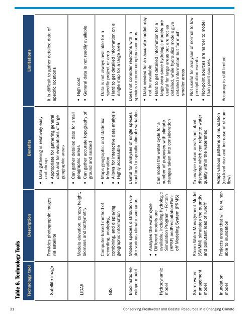
Table 6. Technology Tools<br />
Technology tool Description Benefits Limitations<br />
Satellite image<br />
Provides photographic images<br />
via satellite<br />
• Data gather<strong>in</strong>g is relatively easy<br />
<strong>and</strong> cheap<br />
• Appropriate for gather<strong>in</strong>g general<br />
data <strong>and</strong> for evaluations of large<br />
geographic areas<br />
It is difficult to gather detailed data of<br />
specific locations<br />
LIDAR<br />
Models elevation, canopy height,<br />
biomass <strong>and</strong> bathymetry<br />
• Can gather detailed data for small<br />
geographic areas<br />
• Can gather accurate topography of<br />
ground <strong>and</strong> seabed<br />
• High cost<br />
• General data is not readily available<br />
GIS<br />
Computer-based method of<br />
record<strong>in</strong>g, analyz<strong>in</strong>g,<br />
comb<strong>in</strong><strong>in</strong>g, <strong>and</strong> display<strong>in</strong>g<br />
geographic <strong>in</strong>formation<br />
• Maps geographic <strong>and</strong> statistical<br />
<strong>in</strong>formation<br />
• Allows for <strong>in</strong>teractive data analysis<br />
• Highly accessible<br />
• Data is not always available for a<br />
specific project or area<br />
• Hard to get detailed <strong>in</strong>formation on a<br />
s<strong>in</strong>gle map for a large area<br />
Bioclimatic envelope<br />
model<br />
Models species distribution under<br />
various climate scenarios<br />
Useful for analyses of s<strong>in</strong>gle species<br />
reactions to specific climate variables<br />
Does not consider reactions with <strong>in</strong><br />
species or more complex scenarios<br />
Hydrodynamic<br />
model<br />
• Analyzes the water cycle<br />
• Different models are<br />
available, <strong>in</strong>clud<strong>in</strong>g Hydrologic<br />
Simulation Program -- Forta<strong>in</strong><br />
(HPSF) <strong>and</strong>Precipitation-Runoff<br />
Model<strong>in</strong>g System (PRMS)<br />
Can model the water cycle for a<br />
number of purposes with climate<br />
changes taken <strong>in</strong>to consideration<br />
• Data needed for an accurate model may<br />
not be available<br />
• Hard to get detailed <strong>in</strong>formation for a<br />
large area s<strong>in</strong>ce hydrologic models are<br />
useful for large areas but are not as<br />
detailed, while hydraulics models give<br />
detailed <strong>in</strong>formation but for much<br />
smaller areas<br />
Storm water<br />
management<br />
model<br />
Storm Water Management Model<br />
(SWMM) simulates the quantity<br />
<strong>and</strong> pollutant load of runoff<br />
To analyze urban area’s pollutant<br />
discharge which can relate to water<br />
quality with<strong>in</strong> the watershed<br />
• Not useful for analyses of normal to low<br />
precipitation events<br />
• Non-po<strong>in</strong>t sources are harder to model<br />
than po<strong>in</strong>t sources<br />
Inundation<br />
model<br />
Projects areas that will be vulnerable<br />
to <strong>in</strong>undation<br />
Adapt various patterns of <strong>in</strong>undation<br />
(sea-level rise <strong>and</strong> <strong>in</strong>crease of stream<br />
flow)<br />
Accuracy is still limited<br />
31<br />
<strong>Conserv<strong>in</strong>g</strong> <strong>Freshwater</strong> <strong>and</strong> <strong>Coastal</strong> <strong>Resources</strong> <strong>in</strong> a Chang<strong>in</strong>g <strong>Climate</strong>


