National Geoscience Conference 2011 - Department Of Geology ...
National Geoscience Conference 2011 - Department Of Geology ...
National Geoscience Conference 2011 - Department Of Geology ...

Create successful ePaper yourself
Turn your PDF publications into a flip-book with our unique Google optimized e-Paper software.
NATIONAL GEOSCIENCE CONFERENCE <strong>2011</strong><br />
11 – 12 June <strong>2011</strong> • The Puteri Pacific Johor Bahru, Johor, Malaysia<br />
Paper A10<br />
A Tale of Two Airports: the New LCCT, Sepang, and the Senai Airport<br />
Tan Boon Kong<br />
Consultant Engineering Geologist, Petaling Jaya<br />
Email address: tanboonkong@gmail.com<br />
Owing to severe congestion problems in the present Low Cost Carrier Terminal (LCCT) in Sepang, a new LCCT<br />
has been planned and is currently under construction. The new LCCT is located adjacent to the Kuala Lumpur<br />
International Airport (KLIA) in Sepang, and has been re-designated as KLIA2. The terminal or project area is<br />
underlain by thick deposits of Quaternary sediments and peat, with Kenny Hill formation as the underlying bedrock.<br />
The soil profile typically consists of three layers, namely (from top to bottom): Quaternary Sediments/Peat, Residual<br />
Soils (of Kenny Hill formation), and Bedrock (Kenny Hill formation).<br />
The main concern with the construction of the terminal and runway is the settlement or differential settlement<br />
problems arising from the thick Quaternary deposits and peat. Thus, the determination of the spatial distribution and<br />
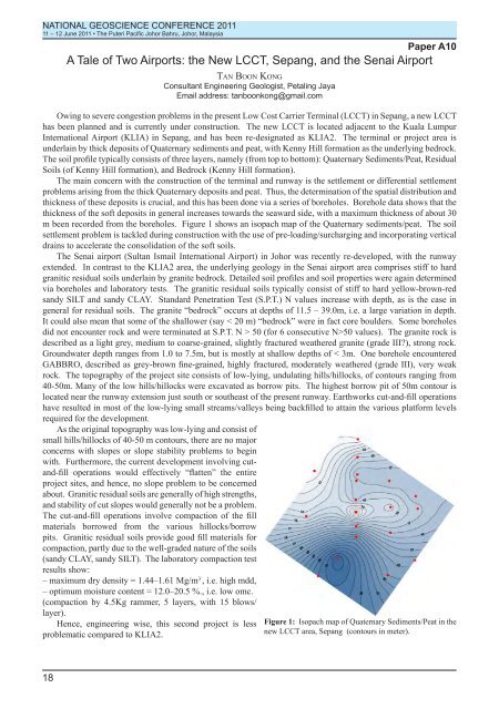
thickness of these deposits is crucial, and this has been done via a series of boreholes. Borehole data shows that the<br />
thickness of the soft deposits in general increases towards the seaward side, with a maximum thickness of about 30<br />
m been recorded from the boreholes. Figure 1 shows an isopach map of the Quaternary sediments/peat. The soil<br />
settlement problem is tackled during construction with the use of pre-loading/surcharging and incorporating vertical<br />
drains to accelerate the consolidation of the soft soils.<br />
The Senai airport (Sultan Ismail International Airport) in Johor was recently re-developed, with the runway<br />
extended. In contrast to the KLIA2 area, the underlying geology in the Senai airport area comprises stiff to hard<br />
granitic residual soils underlain by granite bedrock. Detailed soil profiles and soil properties were again determined<br />
via boreholes and laboratory tests. The granitic residual soils typically consist of stiff to hard yellow-brown-red<br />
sandy SILT and sandy CLAY. Standard Penetration Test (S.P.T.) N values increase with depth, as is the case in<br />
general for residual soils. The granite “bedrock” occurs at depths of 11.5 – 39.0m, i.e. a large variation in depth.<br />
It could also mean that some of the shallower (say < 20 m) “bedrock” were in fact core boulders. Some boreholes<br />
did not encounter rock and were terminated at S.P.T. N > 50 (for 6 consecutive N>50 values). The granite rock is<br />
described as a light grey, medium to coarse-grained, slightly fractured weathered granite (grade III), strong rock.<br />
Groundwater depth ranges from 1.0 to 7.5m, but is mostly at shallow depths of < 3m. One borehole encountered<br />
GABBRO, described as grey-brown fine-grained, highly fractured, moderately weathered (grade III), very weak<br />
rock. The topography of the project site consists of low-lying, undulating hills/hillocks, of contours ranging from<br />
40-50m. Many of the low hills/hillocks were excavated as borrow pits. The highest borrow pit of 50m contour is<br />
located near the runway extension just south or southeast of the present runway. Earthworks cut-and-fill operations<br />
have resulted in most of the low-lying small streams/valleys being backfilled to attain the various platform levels<br />
required for the development.<br />
As the original topography was low-lying and consist of<br />
small hills/hillocks of 40-50 m contours, there are no major<br />
concerns with slopes or slope stability problems to begin<br />
with. Furthermore, the current development involving cutand-fill<br />
operations would effectively “flatten” the entire<br />
project sites, and hence, no slope problem to be concerned<br />
about. Granitic residual soils are generally of high strengths,<br />
and stability of cut slopes would generally not be a problem.<br />
The cut-and-fill operations involve compaction of the fill<br />
materials borrowed from the various hillocks/borrow<br />
pits. Granitic residual soils provide good fill materials for<br />
compaction, partly due to the well-graded nature of the soils<br />
(sandy CLAY, sandy SILT). The laboratory compaction test<br />
results show:<br />
– maximum dry density = 1.44–1.61 Mg/m 3 , i.e. high mdd,<br />
– optimum moisture content = 12.0–20.5 %., i.e. low omc.<br />
(compaction by 4.5Kg rammer, 5 layers, with 15 blows/<br />
layer).<br />
Hence, engineering wise, this second project is less<br />
problematic compared to KLIA2.<br />
Figure 1: Isopach map of Quaternary Sediments/Peat in the<br />
new LCCT area, Sepang (contours in meter).<br />
18