National Geoscience Conference 2011 - Department Of Geology ...
National Geoscience Conference 2011 - Department Of Geology ...
National Geoscience Conference 2011 - Department Of Geology ...

Create successful ePaper yourself
Turn your PDF publications into a flip-book with our unique Google optimized e-Paper software.
NATIONAL GEOSCIENCE CONFERENCE <strong>2011</strong><br />
11 – 12 June <strong>2011</strong> • The Puteri Pacific Johor Bahru, Johor, Malaysia<br />
24<br />
Paper A16<br />
Groundwater contamination in North Kelantan: How serious<br />
Ismail Tawnie*, Anuar Sefie & Saim Suratman<br />
<strong>National</strong> Hydraulic Research Institute of Malaysia (NAHRIM),<br />
Lot 5377, Jalan Putra Permai, 43300 Seri Kembangan, Selangor<br />
*Email address: ismail@nahrim.gov.my<br />
Groundwater is a major source of public water supply in Kelantan, which constitutes 47% of the total water<br />
supply. In the northern part of Kelantan, groundwater contributes about 90% of the total drinking water demand in the<br />
area. A number of groundwater wellfields and monitoring wells have been established in the area. The groundwater<br />
is mainly used for potable water supply, as well as for agricultural and industrial purposes.<br />
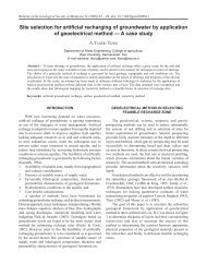
At present, the groundwater consumption is about 146 Ml/d obtained from 94 production wells at 14 wellfields and<br />
treated at 7 groundwater treatment plants (Figure 1 & Table 1). Groundwater from these wellfields is drawn from shallow<br />
aquifer system except in Tanjung Mas, and new wells at Pintu Geng and Kg. Puteh. The demand for groundwater in potable<br />
use is estimated to be 165 Ml/d in 2010 and will increase at a pace of 2.5% per year (Ismail, 2009).<br />
The North Kelantan River Basin is underlain by unconsolidated Quaternary alluvium of marine and fluviatile<br />
origin, with thickness from a few meters to more than 200 m. These alluvial deposits thicken towards the coast.<br />
Bedrock in the south-western part of the Basin consists predominantly of Permian shale, sandstone, phyllite, slate<br />
and volcanic rocks, with granitic rocks are found in the east (MacDonald, 1967).<br />
The alluvium consists mainly of medium to coarse sand with interlayering of gravel, clay and silt. The sand<br />
layers of different thickness occur separated by silt or clay layers locally forming the confining layers. The shallow<br />
sand layers are generally unconfined with areas of confined and semi-confined occurring locally.<br />
The alluvial aquifers in the study area constitute an important source of groundwater for public water supply and<br />
contribute to the 90% of the total drinking water demand. The aquifers consist of two main aquifer systems known<br />
as shallow aquifer which is mostly unconfined but occasionally confined or semi-confined, with thickness normally<br />
2-3 m and may reach up to 17.5 m, usually referred to as first aquifer. The second is deep aquifer which is mainly<br />
confined, with thickness usually more than 15 m. This deep aquifer comprises three different layers, separated from<br />
each other by semi-permeable strata of silt, normally referred to as the second, third and fourth aquifer (Saim, 1997).<br />
These two main aquifer systems are hydraulically interconnected especially the first and the second aquifer as<br />
they are mainly separated by semi-permeable strata of silt. The interconnection between the shallow and deeper<br />
aquifers, or leakage from the lower or upper aquifers depends significantly on the lithology of the aquifer at a<br />
particular location.<br />
The first aquifer is notably productive for development; however, since it is shallow, it is threatened by pollution<br />
as groundwater development is concentrated in the populated area of Kota Bharu town. The second aquifer is<br />
generally not suitable for large-scale exploitation as the groundwater from this layer of aquifer is normally saline.<br />
The third aquifer is the most promising in terms of production and also protected from potential pollution. The<br />
fourth aquifer is not distributed uniformly throughout the entire region as it forms the contact with the underlying<br />
granite or meta-sedimentary rocks. Regionally, the groundwater flows north to north-east.<br />
The population growth heightens the risk of contamination of the groundwater. The unsystematic sewage<br />
treatment and waste disposal expose the water resources to biological contamination such as Coliform and E. coli.<br />
Industrial sectors also contribute to the increase in risk of groundwater contamination. Automobile workshops, for<br />
example, have the potential to cause oil and grease contamination. The same goes with petrol stations when there is<br />
a leakage in the underground storage tank.<br />
Agricultural sectors, on the other hand, contribute to the contamination through the use of fertilisers which<br />
increase the contents of nitrate and nitrite in the soil and subsequently seep through to the groundwater. Heavy<br />
pumping of groundwater during dry season (January to March) for tobacco crop causes groundwater levels to drop<br />
and might induce saltwater intrusion particularly in areas near the coastal line. But in reality, there are no significant<br />
groundwater lowering in the area because during the rainy (wet) season from October to December, complete water<br />
level recovery occurs. If there is a significant lowering of the water levels, it enhances the flow in the aquifer and<br />
increase contaminant transport.<br />
References<br />
Ismail, W. M. Z. W., 2009. Groundwater for Domestic Needs in Kelantan. In Proc. of Groundwater Colloquium 2009, Minerals<br />
and <strong>Geoscience</strong> <strong>Department</strong> Malaysia and Academy of Sciences Malaysia, p149-156.<br />
MacDonald, S., 1967. The <strong>Geology</strong> and Mineral Resources of North Kelantan and North Terengganu. Geological Survey of<br />
Malaysia, Memoir 10, 202p.<br />
Saim, S. 1997. Groundwater Protection in North Kelantan, Malaysia: An Integrated Mapping Approach Using Modelling and GIS.<br />
Ph.D. Thesis. University of Newcastle Upon Tyne, United Kingdom. (unpublished). 362p.