

Metropolitan Melbourne Investigation Discussion Paper - Victorian ...
Metropolitan Melbourne Investigation Discussion Paper - Victorian ...
Metropolitan Melbourne Investigation Discussion Paper - Victorian ...

Create successful ePaper yourself
Turn your PDF publications into a flip-book with our unique Google optimized e-Paper software.
The basement rocks also provided more undulating<br />
topography, such as Richmond Hill, which became<br />
sought after residential locations; fl atter volcanic plains<br />
were left for industry including pastoral runs, and<br />
settlements for the working class. The Collingwood<br />
fl at is situated on heavy clay soil derived from a Newer<br />
Volcanics basalt fl ow. With ready access to the Yarra<br />
River as a drain, this area soon became a focus for<br />
those industries specialising in noxious waste such as<br />
tanneries, abattoirs, soap and candle manufacturing<br />
and wool and sheepskin production. 34,35<br />
Newer volcanics basalts are resistant to weathering<br />
and were recognised as an excellent building material.<br />
This rock is used extensively throughout the region,<br />
and known as bluestone and blue metal. The fi rst<br />
quarries, which opened in the 1830s and 1840s, were<br />
located in the Fitzroy Gardens, Carlton and Clifton<br />
Hill. 33 Other building materials were tried over time,<br />
including the Permian age sandstones quarried at<br />
Bacchus Marsh. Many of these were found to weather<br />
over time and proved to be far less suitable than<br />
other sandstones procured from more distant areas<br />
of the colony such as the Grampians. Tasmanian<br />
sandstone was used extensively in early buildings.<br />
Other building materials such as sand and gravel<br />
were readily available in a number of locations (e.g.<br />
Lilydale toppings).<br />
By far the greatest geological infl uence on <strong>Melbourne</strong>’s<br />
development was the discovery of gold in Warrandyte<br />
in 1851. Soon followed by discoveries in the gold<br />
fi elds at Ballarat and Bendigo, the riches this mineral<br />
resource brought to the city of <strong>Melbourne</strong> had far<br />
reaching effects on the development of the city (see<br />
chapter 3).<br />
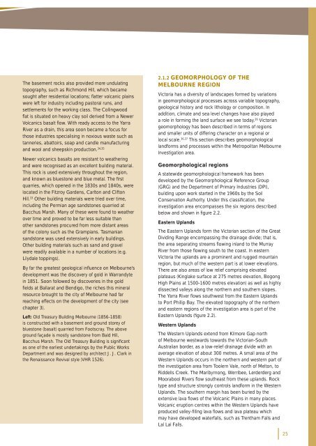
Left: Old Treasury Building <strong>Melbourne</strong> (1856-1858)<br />
is constructed with a basement and ground storey of<br />
bluestone (basalt) quarried from Footscray. The above<br />
ground façade is mostly sandstone from Bald Hill,<br />
Bacchus Marsh. The Old Treasury Building is signifi cant<br />
as one of the earliest undertakings by the Public Works<br />
Department and was designed by architect J. J. Clark in<br />
the Renaissance Revival style (VHR 1526).<br />
2.1.2 GEOMORPHOLOGY OF THE<br />
MELBOURNE REGION<br />
Victoria has a diversity of landscapes formed by variations<br />
in geomorphological processes across variable topography,<br />
geological history and rock lithology or composition. In<br />
addition, climate and sea level changes have also played<br />
a role in forming the land surface we see today. 26 <strong>Victorian</strong><br />
geomorphology has been described in terms of regions<br />
and smaller units of differing character on a regional or<br />
local scale. 36,37 This section describes geomorphological<br />
landforms and processes within the <strong>Metropolitan</strong> <strong>Melbourne</strong><br />
<strong>Investigation</strong> area.<br />
Geomorphological regions<br />
A statewide geomorphological framework has been<br />
developed by the Geomorphological Reference Group<br />
(GRG) and the Department of Primary Industries (DPI),<br />
building upon work started in the 1960s by the Soil<br />
Conservation Authority. Under this classifi cation, the<br />
investigation area encompasses the six regions described<br />
below and shown in fi gure 2.2.<br />
Eastern Uplands<br />
The Eastern Uplands form the <strong>Victorian</strong> section of the Great<br />
Dividing Range encompassing the drainage divide; that is,<br />
the area separating streams fl owing inland to the Murray<br />
River from those fl owing south to the coast. In eastern<br />
Victoria the uplands are a prominent and rugged mountain<br />
region, but much of the western part is at lower elevations.<br />
There are also areas of low relief comprising elevated<br />
plateaus (Kinglake surface at 275 metres elevation, Bogong<br />
High Plains at 1500-1600 metres elevation) as well as highly<br />
dissected valleys along the northern and southern slopes.<br />
The Yarra River fl ows southwest from the Eastern Uplands<br />
to Port Phillip Bay. The elevated topography of the northern<br />
and eastern regions of the investigation area is part of the<br />
Eastern Uplands (fi gure 2.2).<br />
Western Uplands<br />
The Western Uplands extend from Kilmore Gap north<br />
of <strong>Melbourne</strong> westwards towards the <strong>Victorian</strong>-South<br />
Australian border, as a low-relief drainage divide with an<br />
average elevation of about 300 metres. A small area of the<br />
Western Uplands occurs in the northern and western part of<br />
the investigation area from Toolern Vale, north of Melton, to<br />
Riddells Creek. The Maribyrnong, Werribee, Lerderderg and<br />
Moorabool Rivers fl ow southeast from these uplands. Rock<br />
type and structure strongly controls landform in the Western<br />
Uplands. The southern margin has been buried by the<br />
extensive lava fl ows of the Volcanic Plains in many places.<br />
Volcanic eruption centres within the Western Uplands have<br />
produced valley-fi lling lava fl ows and lava plateau which<br />
may have developed waterfalls, such as Trentham Falls and<br />
Lal Lal Falls.<br />
25


