

Metropolitan Melbourne Investigation Discussion Paper - Victorian ...
Metropolitan Melbourne Investigation Discussion Paper - Victorian ...
Metropolitan Melbourne Investigation Discussion Paper - Victorian ...

You also want an ePaper? Increase the reach of your titles
YUMPU automatically turns print PDFs into web optimized ePapers that Google loves.
freshwater from the river was a key reason for the<br />
establishment of <strong>Melbourne</strong>. Over the years, the river has<br />
been altered in many ways by the straightening of several<br />
sections and the carving of new channels.<br />
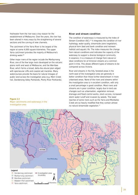
The catchment of the Yarra River is the largest of the<br />
region at some 4,000 square kilometres. The upper<br />
Yarra catchment provides the majority of <strong>Melbourne</strong>’s<br />
drinking water. 40<br />
Other major rivers of the region include the Maribyrnong<br />
River, one of the few large rivers developed on the volcanic<br />
plains north and west of <strong>Melbourne</strong>, and the Werribee<br />
River, which forms a broad, delta-like alluvial plain edged<br />
with spectacular cliffs and coastal salt marshes. Many<br />
watercourses provide the basis for natural linkages of<br />
public land across the investigation area (e.g. Merri Creek<br />
trail, Dandenong Valley Parklands, Plenty River Parklands).<br />
Figure 2.3<br />
Major catchments and waterways in the<br />
investigation area<br />
River and stream condition<br />
The condition of waterways is measured by the Index of<br />
Stream Condition (ISC). 41 It integrates the condition of river<br />
hydrology, water quality, streamside zone (vegetation),<br />
physical form (bed and bank condition and instream<br />
habitat) and aquatic life. The index measures the change<br />
from natural conditions and indicates the capacity of the<br />
waterway to support a diverse biological community.<br />
In essence, it is a measure of change from natural or<br />
ideal conditions for all <strong>Victorian</strong> streams at a common<br />
point in time. This allows different types of streams to be<br />
compared across Victoria.<br />
River and streams in the hilly, forested areas in the<br />
north-east of the investigation area are generally in<br />
better condition than those further downstream in more<br />
urbanised areas. None of the rivers and streams within<br />
the investigation area is in excellent condition, with only<br />
a small percentage in good condition. Most rivers and<br />
streams are in poor condition, largely due to land use<br />
changes such as urbanisation, vegetation removal,<br />
drainage and fl ood control works, stock access, increased<br />
storm water runoff and invasion by weeds. The lower<br />
reaches of some rivers such as the Yarra and Mordialloc<br />
Creek are so heavily modifi ed that they contain almost<br />
no natural streamside vegetation. 17<br />
29


