risk management - monitor ii
risk management - monitor ii
risk management - monitor ii

You also want an ePaper? Increase the reach of your titles
YUMPU automatically turns print PDFs into web optimized ePapers that Google loves.
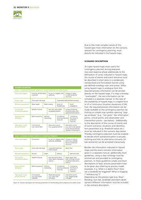
32 Monitor II Scenarios<br />
Monitor II Scenarios 33<br />
ROCK (fall, topple, spread, slide) – STEPWISE ONSET AND SUDDEN ONSET<br />
Cause and triggers Weathering Erosion Induction by shock<br />
(e.g. earthquakes)<br />
Definition of hot spots in the<br />
process and intervention domain<br />
SCENARIO DESCRIPTION<br />
FLOW -– FLOODING (Stepwise onset) e.g. river flooding in flood plains<br />
Cause and triggers Intensive rainfall and/or<br />
snowmelt<br />
Ice jam or clogging, lake<br />
outbursts<br />
Collapse of dykes<br />
or other protective<br />
structures<br />
Process type Clear water discharge Suspended load/ bed load transport<br />
Relevant parameters Water depth Water velocity Extent of<br />
flooded area<br />
Forecasting/<br />
<strong>monitor</strong>ing options<br />
Expected time<br />
to impact<br />
“Hot spots” in the<br />
process domain<br />
Weather forecast<br />
With forecasting<br />
Critical points<br />
(e.g. natural dam)<br />
Without<br />
forecasting<br />
Rain fall, water depth<br />
at gauging stations<br />
Considering<br />
existing protection<br />
measures<br />
Observation points<br />
(e.g. gauging stations)<br />
FLOW – FLOODING (sudden onset) e.g. mountain torrents<br />
Cause and triggers Cloud burst Ice jam or clogging, lake<br />
outbursts, landslides<br />
Process type Clear water discharge Suspended load/ bed<br />
load transport<br />
Flood<br />
propagation<br />
Linkage of defined<br />
threshold values with<br />
expected flood extend<br />
Considering<br />
the failure of<br />
protection<br />
measures<br />
Intervention points<br />
(e.g. weirs to be opened<br />
to use natural retention<br />
capacity in flood plains)<br />
Collapse of natural<br />
dams (e.g. landslide<br />
dams) or protective<br />
structures<br />
Debris flow<br />
Relevant parameters Volume Depth Velocity Sediment load<br />
Forecasting/<br />
<strong>monitor</strong>ing options<br />
Expected time<br />
to impact<br />
“Hot spots” in the<br />
process domain<br />
Weather forecast<br />
With forecasting<br />
Critical points<br />
(e.g. reactivated<br />
landslide)<br />
Without<br />
forecasting<br />
Rain fall and duration,<br />
water depth at gauging<br />
stations<br />
Observation points<br />
(e.g. water level<br />
at bridges)<br />
Considering<br />
existing protection<br />
measures<br />
Water depth, bed,<br />
bank and slope erosion<br />
at defined observation<br />
stations.<br />
Considering<br />
the failure of<br />
protection<br />
measures<br />
Intervention points<br />
(e.g. clogged gorge<br />
or bridge)<br />
Figure 33: Scenario description and necessary parameters for flow/flooding events (stepwise and sudden onset).<br />
Due to the more complex nature of this<br />
hazard type more information on the scenario,<br />
relevant for contingency planning, must<br />
directly be indicated in the hazard maps.<br />
Scenario description<br />
To make hazard maps more useful for<br />
contingency planners during preparedness<br />
and response phase additionally to the<br />
delineation of zones indicated in hazard maps,<br />
the course of events and event scenarios must<br />
be described in short texts in a condensed,<br />
standardized and formalized manner using<br />
pre-defined ontology rules and syntax. When<br />
using hazard maps in analogue form this<br />
required process information can be printed<br />
directly on the hazard maps. If a map is thereby<br />
“ overloaded”, the text information can be<br />
included is a separate manual. In the case of<br />
the availability of hazard maps in a digital form<br />
or of a Continuous Situation Awareness (CSA)<br />
tool, the required process information can be<br />
made available to the contingency planners by<br />
clicking on simple map symbols opening “popup<br />
windows” (e.g. “hot spots” like infor mation<br />
points, critical points, and observation and<br />
intervention points – see below) . Additionally<br />
to the description of the course of events and<br />
of event scenarios, situations and identification<br />
parameters (e.g. threshold values etc.)<br />
must be indicated in the scenario description.<br />
Thereby contingency planners must be enabled<br />
to decide which scenario/situation is actually<br />
evolving and links to alternative scenarios (or<br />
sub-scenarios) can be activated interactively.<br />
Besides the information indicated in hazard<br />
maps and the event scenario information<br />
given in a separate manual, additionally short<br />
guidelines, using a clear ontology must be<br />
worked out and provided to contingency<br />
planners. In these guidelines simple and short<br />
descriptions of basic process parameters have<br />
to be given also referring to process model<br />
examples. E.g. What is a debris flow How<br />
can a landslide be triggered What is clogging<br />
(“Verklausung”)<br />
Depending on the process type (e.g. flow/<br />
flooding; rock fall; landslide) and event development<br />
different information must be included<br />
in the scenario description.<br />
Process type Fall Topple Spread Slide<br />
Relevant parameters Block size Volume Bounce height Impact force<br />
Forecasting/<br />
<strong>monitor</strong>ing options<br />
Expected time<br />
to impact<br />
“Hot spots” in the<br />
process domain<br />
Extensometers measuring<br />
opening of fissures<br />
With forecasting<br />
Critical points<br />
(source area)<br />
Without<br />
forecasting<br />
Remote sensing methods<br />
measuring displacement<br />
Considering<br />
existing protection<br />
measures<br />
Observation points<br />
(measurement/ <strong>monitor</strong>ing<br />
of displacement)<br />
LANDSLIDE (sliding, creeping, flowing) – STEPWISE ONSET AND SUDDEN ONSET<br />
Cause and triggers<br />
Process type<br />
Sediment<br />
composition<br />
Translational<br />
sliding<br />
Existing<br />
sliding plane<br />
Hydrostatic pressure<br />
and moisture<br />
Manual measurements of<br />
displacement<br />
Figure 34: Scenario description and necessary parameters for rock movement and landslide events<br />
(stepwise and sudden onset).<br />
Considering<br />
failure of protection<br />
measures<br />
Intervention points<br />
(removal of unstable<br />
parts; permanent and<br />
mobile protection<br />
measures)<br />
Slope<br />
Rotational sliding Flowing Creeping<br />
Relevant parameters Activation Volume Depth Speed Run out<br />
length<br />
Forecasting/<br />
<strong>monitor</strong>ing options<br />
Expected time<br />
to impact<br />
“Hot spots” in the<br />
process domain<br />
Weather<br />
forecast and<br />
measurement of<br />
precipitation<br />
Below<br />
reaction time<br />
(=FAST)<br />
Above<br />
reaction time<br />
(=SLOW)<br />
Critical points<br />
(source area)<br />
Sensors<br />
measuring<br />
displacement<br />
and moisture<br />
With<br />
forecasting<br />
Without<br />
forecasting<br />
Remote Sensing<br />
methods to<br />
measure<br />
displacement<br />
Observation points<br />
(measurement/<strong>monitor</strong>ing<br />
of displacement)<br />
Considering<br />
existing<br />
protection<br />
measures<br />
Impact<br />
force<br />
Manual<br />
measurements<br />
of displacement<br />
Considering<br />
failure of<br />
protection<br />
measures<br />
Intervention points<br />
(drainage of sliding mass;<br />
lowering of groundwater<br />
table by pumping wells,<br />
auger piles, anchor walls<br />
etc.)<br />
Within the co-operation of hazard experts<br />
and contingency planners “hot spots” can be<br />
defined in the process (p), damage/loss (d) and<br />
intervention (i) domains. These “hot spots” are<br />
indicators for information linking the hazard/<br />
process- and the contingency/intervention<br />
fields by providing key process information or<br />
indications of required measures. These “hot<br />
spots” comprise of information points, critical<br />
points, observation points and intervention<br />
points.<br />
THE PROCESS ORIENTED DOMAIN:<br />
Process oriented information point<br />
(p-INFO): Using prcess-oriented information<br />
points general information on the hazard<br />
process/ event scenario is given. Depending on<br />
the event scenarios the main information<br />
is provided in a condensed form based on a<br />
clear ontology (see above).<br />
Process oriented critical point (p-CP):<br />
A process oriented critical point is defined by<br />
the hazard mapping expert based on historic<br />
information and a sound hazard assessment<br />
procedure and is related to the process<br />
development itself. This point can indicate<br />
the area where a process is starting (e.g. the<br />
detachment zone of a landslide or rock fall),<br />
where a process is transformed (e.g. sediment<br />
input from the river flanks leading to debris<br />
flow), or diverted (e.g. clogged bride) in<br />
different directions – possibly leading to subscenarios.<br />
Process oriented observation point<br />
(p-OP): At a process-oriented observation<br />
point indicates a location where the process<br />
can best/most significantly be observed or<br />
<strong>monitor</strong>ed. An observation point can e.g.<br />
indicate the location of a sensor installed in the<br />
preparedness phase to <strong>monitor</strong> a process. In<br />
the warning phase additional technical devices<br />
may be installed or “observers” may be sent<br />
to the defined locations to observe the process<br />
development according to a pre-defined<br />
Standard Operation Procedure (SOP).<br />
Process oriented intervention point (p-IP):<br />
Process oriented intervention points used<br />
during the preparedness phase indicate all<br />
technical and non-technical prevention measures<br />
installed. During the warning phase, at a<br />
process oriented intervention point an action<br />
may be taken, directly influencing the process<br />
or event development itself. In the case