DPA 5 Steep Slopes - District of Sechelt
DPA 5 Steep Slopes - District of Sechelt
DPA 5 Steep Slopes - District of Sechelt

You also want an ePaper? Increase the reach of your titles
YUMPU automatically turns print PDFs into web optimized ePapers that Google loves.
<strong>DPA</strong> 5 – <strong>Steep</strong> <strong>Slopes</strong><br />
Location<br />
<strong>DPA</strong> 5 applies to all lands with a slope <strong>of</strong><br />
20% or greater for a minimum horizontal<br />
distance <strong>of</strong> 10 metres. Lands with steep<br />
slopes <strong>of</strong> 20-30% and 30% or greater are<br />
shown generally on Map Schedules E1-<br />
E3. Site specific field review is required<br />
to determine actual extent and location<br />
<strong>of</strong> steep slopes.<br />
<strong>DPA</strong> 5 applies to all subdivisions and<br />
development, except where specifically<br />
exempted.<br />
Category<br />
• Protection <strong>of</strong> the natural<br />
environment, its ecosystems and<br />
biodiversity.<br />
• Protection <strong>of</strong> development from<br />
hazardous conditions.<br />
• Establishment <strong>of</strong> objectives for the<br />
form and character <strong>of</strong> intensive<br />
residential development.<br />
Justification<br />
The forested and sloped hillsides are a<br />
highly important visual resource, as well<br />
as an environmental resource due to<br />
extensive tree cover. Some <strong>of</strong> these<br />
sloped areas may provide opportunities<br />
for residential development with<br />
spectacular views. However, trends<br />
toward clear-cutting <strong>of</strong> the site<br />
combined with much larger houses and<br />
smaller lots have greatly altered the<br />
natural landscape <strong>of</strong> some sloped<br />
areas. Additional infrastructure such as<br />
booster pump stations, reservoirs,<br />
pressure reducing valves, sanitary sewer<br />
lift stations are commonly needed in<br />
steep areas. Financial costs <strong>of</strong> installing<br />
and maintaining services in hillside areas<br />
can be significantly higher than in less<br />
sloped areas, resulting in higher longterm<br />
public costs for this form <strong>of</strong><br />
development.<br />
Special care is needed to ensure new<br />
development is sensitively integrated<br />
with the natural contours and landforms<br />
<strong>of</strong> the site, and important<br />
habitat/forested areas are protected.<br />
This requires a shift away from traditional<br />
subdivision layouts, servicing and<br />
building forms. Using “conservation<br />
design” approaches can significantly<br />
reduce the impact and costs <strong>of</strong><br />
development, while yielding the same<br />
number <strong>of</strong> units as conventional layout.<br />
Clustered development using a mix <strong>of</strong><br />
housing forms and densities is more<br />
appropriate in steeply sloped lands than<br />
uniform, conventional lots.<br />
<strong>Steep</strong>ness <strong>of</strong> slopes does not necessarily<br />
correlate with stability <strong>of</strong> slopes, which<br />
depends on factors such as geological<br />
materials, soils, moisture content and<br />
vegetation cover. However,<br />
precautions are needed to ensure<br />
development activity or resulting<br />
retaining structures do no create<br />
hazardous conditions. (See guidelines<br />
for <strong>DPA</strong> 4 hazard designations that may<br />
also apply to these steeply sloped<br />
lands.)<br />
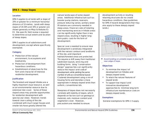
Avoid building on unstable slopes or placing fill<br />
near edge <strong>of</strong> slope.<br />
<br />
Objectives<br />
• To minimize the impact <strong>of</strong><br />
development on hillsides and<br />
steeply sloped lands.<br />
• To retain the natural features <strong>of</strong><br />
sloped lands<br />
• To support low impact and<br />
innovative development<br />
approaches to minimize long-term<br />
infrastructure maintenance costs on<br />
steeply sloped lands.<br />
Exemptions<br />
General exemptions for <strong>DPA</strong> 1-5 apply.<br />
<strong>District</strong> <strong>of</strong> <strong>Sechelt</strong> Bylaw 492, 2010 Environmental and Natural Hazard <strong>DPA</strong> Guidelines 156<br />
Official Community Plan
Guidelines<br />
Development Permits issued in <strong>DPA</strong> 5 will<br />
be in accordance with the following:<br />
1. No site disturbance, clearing,<br />
building, or other development <strong>of</strong><br />
land shall take place except in<br />
accordance with a development<br />
permit or specifically exempted by<br />
the <strong>District</strong>.<br />
2. Land with slopes over 30% is<br />
generally not suitable for residential<br />
development and development<br />
should be avoided. Development<br />
may be considered where it can be<br />
demonstrated that the proposed<br />
development will not create<br />
environmental or visual impacts, can<br />
be sensitively integrated with the<br />
Slope is calculated by dividing the<br />
vertical height by the horizontal distance<br />
(rise over run). Many properties have<br />
complex slopes requiring detailed analysis<br />
terrain, and presents no hazards to<br />
persons or property.<br />
3. Land with slopes from 20-30% may<br />
be suitable for building at lower<br />
densities or with special site planning<br />
techniques.<br />
Report/Submission requirements<br />
4. Prior to consideration <strong>of</strong><br />
development or subdivision on lands<br />
within <strong>DPA</strong> 5, reports prepared by a<br />
Qualified Pr<strong>of</strong>essional(s) are<br />
required.<br />
5. The report shall provide:<br />
(a) An inventory and accurate plan<br />
<strong>of</strong> site features, including tree<br />
cover, rock outcroppings,<br />
watercourses and assessment <strong>of</strong><br />
soil types, depths and conditions;<br />
(b) Plans showing the location <strong>of</strong> all<br />
existing and proposed buildings<br />
and structures, building<br />
envelopes, utility services,<br />
driveways and other impervious<br />
surfaces;<br />
(c) A slope analysis, geotechnical<br />
assessment, and slope stability<br />
plan providing assessment <strong>of</strong> the<br />
potential for landslide, landslip or<br />
erosion, detailing how the<br />
proposed development is to be<br />
designed and constructed to<br />
prevent any destabilization or<br />
erosion <strong>of</strong> the slope. This will<br />
include plans showing lands with<br />
0-10%, 10-20%, 20-30% and 30%<br />
and over grades at a 1m contour<br />
interval.<br />
(d) Location and amount <strong>of</strong><br />
anticipated removal or fill.<br />
(e) View corridor analysis to<br />
determine the visual impact <strong>of</strong><br />
development. The <strong>District</strong> may<br />
also require a 3D digital terrain<br />
model illustrating pre and postdevelopment<br />
conditions,<br />
illustrating extents <strong>of</strong> cuts and fills ,<br />
clearing and building<br />
placements;<br />
(f) A site grading plan including<br />
sections through each lot that<br />
clearly shows building envelopes,<br />
including the top <strong>of</strong> cut and toe<br />
<strong>of</strong> slope, and the slopes <strong>of</strong><br />
adjacent uphill and downhill<br />
adjacent lots.<br />
(g) Recommendations on<br />
appropriate building envelopes<br />
or setbacks in relation to potential<br />
slope hazard, with specific<br />
recommendations and criteria for<br />
design, construction and<br />
maintenance.<br />
(h) Detailed measures to safeguard<br />
neighbouring properties and<br />
structures arising from the<br />
proposed construction or site<br />
preparation (including blasting)<br />
(i) Identify the anticipated effects <strong>of</strong><br />
septic and drainage systems on<br />
slope stability;<br />
(j) Any geotechnical reports must<br />
meet the report guidelines for<br />
Legislated Landslide Assessments<br />
for Proposed Residential<br />
Development in British Columbia<br />
published by the Association <strong>of</strong><br />
<strong>District</strong> <strong>of</strong> <strong>Sechelt</strong> Bylaw 492, 2010 Environmental and Natural Hazard <strong>DPA</strong> Guidelines 157<br />
Official Community Plan
Pr<strong>of</strong>essional Engineers and<br />
Geoscientists <strong>of</strong> British Columbia,<br />
March 2006, including submission<br />
<strong>of</strong> Schedule D (Landslide<br />
Assessment Assurance<br />
Statement) to specify that the<br />
land may be safely used for the<br />
use intended.<br />
Basic Design Principles<br />
6. Design the project to fit the site<br />
rather than alter the site to fit the<br />
project.<br />
7. Development density calculations<br />
will be based on the areas <strong>of</strong> the<br />
property excluding land areas with<br />
original slopes greater than 30% (see<br />
OCP policy 3.7).<br />
8. Use conservation design site<br />
planning approaches that:<br />
(a) Minimize alteration <strong>of</strong> natural<br />
grades.<br />
(b) Increase lot sizes as slope<br />
increases.<br />
(c) Preserve natural features and<br />
vegetation and incorporate them<br />
into the design <strong>of</strong> the project.<br />
Clustered development preserves nature features while yielding<br />
the same number <strong>of</strong> residential units (Vision Plan)<br />
(d) Cluster development on less<br />
steep portions <strong>of</strong> the site.<br />
(e) Reduce footprints <strong>of</strong> buildings.<br />
(f) Step buildings to reflect the slope<br />
<strong>of</strong> the site.<br />
(g) Use variations in lot sizes and<br />
subdivision layout to reflect<br />
natural site contours.<br />
(h) Reduce the length <strong>of</strong> roads.<br />
(i) Limit the extent <strong>of</strong> hard<br />
surfaced/paved areas.<br />
(j) Use low impact stormwater<br />
management<br />
(k) Share driveways to reduce<br />
paved areas and cut and fill <strong>of</strong><br />
slopes.<br />
Natural Areas/Vegetation<br />
9. Natural slope features including<br />
treed ridgelines, hilltops, rock<br />
outcrops, drainage courses, mature<br />
vegetation and forest stands shall be<br />
retained in their natural state and<br />
incorporated into the design <strong>of</strong> the<br />
project.<br />
10. Preserve native vegetation, with<br />
removal only where necessary for<br />
the building<br />
foundation, septic<br />
system, driveway, and<br />
landscaping directly<br />
adjacent to the house.<br />
11. Any trees or vegetation<br />
removed shall be<br />
replanted in order to<br />
prevent potential<br />
erosion, landslip or<br />
rockfalls, to stabilize<br />
slopes and to restore<br />
Subdivision layout should retain natural site<br />
features (example on left)<br />
visual quality. Native plant<br />
materials and tree species are<br />
preferred to restore the natural<br />
character and biodiversity <strong>of</strong> the<br />
site.<br />
12. A detailed landscape plan<br />
prepared by a Qualified Pr<strong>of</strong>essional<br />
shall be submitted and accepted by<br />
the <strong>District</strong> as part <strong>of</strong> the<br />
development permit.<br />
Building Sites<br />
13. Building sites should fit with natural<br />
slope contours such that structural<br />
retaining walls or extensive cut and<br />
fill are not required, and so that no<br />
blasting or significant soil/rock<br />
removal or fill is required to build on<br />
the site.<br />
14. No fill or excavated materials should<br />
be placed near the top <strong>of</strong> slopes or<br />
along drainage channels.<br />
15. Every residential lot created by<br />
subdivision shall have a safe building<br />
envelope located on stable slopes<br />
at less than 20% grade.<br />
<strong>District</strong> <strong>of</strong> <strong>Sechelt</strong> Bylaw 492, 2010 Environmental and Natural Hazard <strong>DPA</strong> Guidelines 158<br />
Official Community Plan
16. Creation <strong>of</strong> large flat terraces on<br />
hillsides in order to expand<br />
developable area or create large<br />
level front or rear yards is not<br />
supported.<br />
17. Where a building or structure is<br />
permitted at the top or foot <strong>of</strong> a<br />
steep slope or bluff, the building<br />
should be set back a minimum<br />
horizontal distance equal to 3.0<br />
times the height <strong>of</strong> the bluff as<br />
measured from the toe <strong>of</strong> the bluff,<br />
or as determined by a Qualified<br />
Pr<strong>of</strong>essional.<br />
Buildings Height and Massing<br />
18. Buildings should have foundations<br />
stepped into the hillside so the<br />
building integrates with the natural<br />
landform. This is particularly<br />
important for houses on the uphill<br />
side <strong>of</strong> the street to avoid overly<br />
dominant appearance.<br />
19. Ro<strong>of</strong> pitches should be aligned to<br />
reflect the natural slope conditions.<br />
Long continuous decks, or large<br />
Minimize the use <strong>of</strong> cut and fill to create<br />
level building sites<br />
cantilevered decks can be visually<br />
overpowering; smaller stepped<br />
decks are preferred.<br />
20. Limit building heights to the height <strong>of</strong><br />
existing tree cover and no higher<br />
than natural ridge lines.<br />
21. Development should be sited to<br />
retain trees and vegetation along<br />
ridgelines.<br />
22. Avoid large unbroken expanses <strong>of</strong><br />
wall and long building masses.<br />
Instead, buildings should have<br />
smaller, less massive, articulated<br />
appearance to fit with the natural<br />
vertical planes in excess <strong>of</strong> two<br />
storeys should be avoided.<br />
23. Large, monolithic housing forms that<br />
are visually prominent on hillsides are<br />
not supported. Buildings should be<br />
stepped to reflect the topography<br />
and sited to reduce visual impacts<br />
from other areas.<br />
<br />
Ro<strong>of</strong> pitch should reflect natural hillside<br />
slope.<br />
Avoid creating flat building areas that require<br />
retaining walls.<br />
Buildings should be stepped down to<br />
reflect natural site contours.<br />
24. Building materials should reflect the<br />
natural setting, and avoid shiny or<br />
reflective surfaces.<br />
25. Variation <strong>of</strong> zoning bylaw standards<br />
for building setbacks may be<br />
supported in steep areas if<br />
necessary to reduce cut and fill,<br />
provide improved level entry,<br />
reduce driveway grades, to enable<br />
<strong>of</strong>f-street parking, or to avoid<br />
hazardous slopes or environmentally<br />
sensitive areas.<br />
<strong>District</strong> <strong>of</strong> <strong>Sechelt</strong> Bylaw 492, 2010 Environmental and Natural Hazard <strong>DPA</strong> Guidelines 159<br />
Official Community Plan
Driveways and Garages<br />
26. Shared driveways are encouraged<br />
to reduce extent <strong>of</strong> site grading,<br />
provided fire department access is<br />
maintained and a reciprocal access<br />
agreement among property owners<br />
is provided.<br />
27. Individual driveway grades should<br />
not exceed 20%. The first 3.5m <strong>of</strong> the<br />
driveway should have a grade no<br />
greater than 7%.<br />
28. The prominence <strong>of</strong> garages should<br />
be minimized using drive- under<br />
and/or detached garages, locating<br />
garages parallel to the street, or by<br />
increasing the setback for upper<br />
storeys above the garage.<br />
landforms that are not characteristic<br />
<strong>of</strong> the natural topography (i.e. linear<br />
terraced benches with no<br />
undulations or irregularities).<br />
30. Finished slopes <strong>of</strong> all cuts and fills<br />
shall not exceed three-to-one (3:1),<br />
unless the applicant can<br />
demonstrate that steeper slopes can<br />
be stabilized and maintained<br />
adequately.<br />
31. Exposed slopes should be replanted<br />
as quickly as possible to prevent<br />
erosion and slope instability. Topsoil<br />
should be retained or replaced to<br />
cover all cut and fill slopes to a<br />
depth not less than 150mm.<br />
32. Excess topsoil and rock materials<br />
from excavations should be used<br />
onsite.<br />
33. Plans shall provide details <strong>of</strong><br />
proposed erosion controls during<br />
construction, and measures to<br />
mitigate erosion on steep slopes in<br />
the finished development.<br />
Retaining Walls<br />
34. The use <strong>of</strong> retaining walls on hillsides<br />
is discouraged; large retaining walls<br />
do not respect the undulating<br />
nature <strong>of</strong> hillsides and should not be<br />
used except where no other<br />
alternative exists.<br />
35. Where necessary, retaining walls<br />
should respect the natural<br />
characteristics <strong>of</strong> the site and should<br />
not present a large uniform wall<br />
face that overpowers the site. A<br />
series <strong>of</strong> smaller stepped walls is<br />
preferred over a large uniform wall.<br />
Buildings below ridge lines and natural<br />
materials integrate with surroundings.<br />
Garage located underneath house<br />
reduces visual impact in sloped areas.<br />
Site Grading<br />
29. Avoid grading or alteration <strong>of</strong> key<br />
topographic features (i.e. rock<br />
outcroppings, ridgelines, cliffs), and<br />
avoid grading that results in<br />
Avoid large scale site clearing<br />
Large retaining walls overwhelm the site,<br />
disrupt views and alter the natural contours.<br />
<strong>District</strong> <strong>of</strong> <strong>Sechelt</strong> Bylaw 492, 2010 Environmental and Natural Hazard <strong>DPA</strong> Guidelines 160<br />
Official Community Plan
Retaining walls adjacent to roads should<br />
allow room for landscaping; terraced walls<br />
are preferable to large single walls.<br />
36. “Living walls” or bioengineered<br />
retaining structures will be<br />
considered as an alternative to hard<br />
surfaced retaining walls.<br />
37. Landscaped terraces created<br />
behind retaining walls shall be <strong>of</strong><br />
sufficient width to allow planting and<br />
maintenance <strong>of</strong> plant materials.<br />
38. Retaining walls must be setback<br />
from utilities and from traveled<br />
portion <strong>of</strong> the road to enable<br />
planting <strong>of</strong> landscape screening.<br />
39. Walls must be structurally competent<br />
and their appearance must<br />
complement natural rock colours<br />
and appearance. Concrete block<br />
retaining walls are not considered<br />
appropriate.<br />
40. As a general guide, retaining walls<br />
should not exceed 3.0m height on<br />
main roads or 1.2 m for individual<br />
properties.<br />
Road design<br />
41. Roads in steep areas should<br />
(a) reflect the natural topography.<br />
Straight grid roads are not<br />
compatible with steep areas.<br />
(b) be located on natural benches<br />
and stable soils.<br />
(c) be kept to the minimum width<br />
and length possible to minimize<br />
the area <strong>of</strong> disturbance.<br />
Alternative layouts should be<br />
used to reduce construction.<br />
(d) avoid alteration <strong>of</strong> natural<br />
drainage patterns<br />
(e) provide adequate surface<br />
drainage.<br />
Natural materials and new planting<br />
can protect steep slopes without<br />
large retaining structures.<br />
42. Reduced design speeds may be<br />
considered where appropriate to<br />
reduce road widths.<br />
43. Long sustained grades should be<br />
avoided. A series <strong>of</strong> small gentle<br />
horizontal and vertical curves are<br />
preferable.<br />
44. With the use <strong>of</strong> narrower local roads,<br />
widened areas for transit and school<br />
bus stops, mail boxes, visitor parking,<br />
garbage pickup etc. must be<br />
predesigned.<br />
Stormwater Management<br />
45. Divert water around and away from<br />
unstable slopes, yard and structures<br />
in a controlled manner. Avoid<br />
saturation <strong>of</strong> slopes and discharge<br />
concentrated water toward storm<br />
drains or street gutters.<br />
Roads and site grading should follow natural<br />
contours (left)), not create unnatural linear<br />
patterns (right).<br />
46. Best management practices for<br />
stormwater should be used for all<br />
steep slope areas, in order to retain<br />
the natural drainage conditions and<br />
reduce impacts to sloped areas:<br />
<strong>District</strong> <strong>of</strong> <strong>Sechelt</strong> Bylaw 492, 2010 Environmental and Natural Hazard <strong>DPA</strong> Guidelines 161<br />
Official Community Plan
Alternative road and pedestrian<br />
designs may be needed in steep<br />
areas. Meandering sidewalks or paths<br />
may be used where they eliminate<br />
steep grades or protect natural site<br />
features. Varying <strong>of</strong>fsets between the<br />
road and sidewalk may be<br />
considered.<br />
(a) Identify and protect natural<br />
drainage flows.<br />
(b) Maintain predevelopment<br />
hydrology through site design,<br />
building and landscape design<br />
techniques that infiltrate, filter,<br />
store, evaporate and detain<br />
stormwater close to its source;<br />
(c) Provide stormwater recharge<br />
areas and maximize onsite<br />
groundwater recharge in stable<br />
areas. This may include<br />
retention or detention ponds,<br />
constructed wetlands, sand<br />
filters, parking areas designed<br />
with bioretention features,<br />
infiltration ditches to return<br />
stormwater to water table.<br />
(d) Minimize impervious surfaces to<br />
reduce stormwater run<strong>of</strong>f and to<br />
prevent excessive run<strong>of</strong>f and<br />
erosion.<br />
(e) Limiting vegetation clearing and<br />
soil disturbance;<br />
(f) Use existing or new vegetation to<br />
slow run<strong>of</strong>f and help stormwater<br />
infiltrate the soil (i.e. filter strips<br />
and grass swales);<br />
(g) Divert downspouts away from<br />
driveway surfaces and into<br />
retention areas/rain gardens or<br />
rain barrels/dry wells to capture,<br />
store and infiltrate stormwater<br />
on-site.<br />
(h) Assess and mitigate any<br />
potential drainage impacts on<br />
downhill properties.<br />
(i) Provide sediment and erosion<br />
control during and after<br />
construction until final<br />
revegetation on all lots is<br />
established.<br />
Parks and Trails<br />
47. Small pocket parks with viewpoints<br />
and trail connections may be the<br />
preferred form or park development<br />
in hillside areas where conventional,<br />
flat parkland is not available.<br />
48. Development applications must<br />
provide details <strong>of</strong> pedestrian access<br />
through the area. Trails or linear<br />
greenways may be used where site<br />
constraints limit the viability <strong>of</strong><br />
conventional sidewalks or shared<br />
roadway pedestrian use.<br />
Fire Hazard<br />
Preserve natural drainage courses to reduce stormwater flows<br />
49. Subdivisions directly adjacent to<br />
forested areas may be required to<br />
prepare a fire interface hazard<br />
assessment. Recommendations <strong>of</strong><br />
that plan may be incorporated into<br />
the development permit, including<br />
fire resistant building materials,<br />
removal <strong>of</strong> risky vegetation/fuel,<br />
replanting with appropriate<br />
vegetation and building sprinklers.<br />
<strong>District</strong> <strong>of</strong> <strong>Sechelt</strong> Bylaw 492, 2010 Environmental and Natural Hazard <strong>DPA</strong> Guidelines 162<br />
Official Community Plan
Covenants<br />
50. The <strong>District</strong> may require a S.219<br />
covenant to protect any<br />
environmentally sensitive or visually<br />
important natural areas, to protect<br />
any structural fill or engineered<br />
slopes.<br />
Permit Conditions<br />
51. A Development permit issued for<br />
lands in <strong>DPA</strong> 5 may:<br />
(a) Specify areas <strong>of</strong> land that must<br />
remain free <strong>of</strong> development,<br />
except in accordance with any<br />
conditions contained in the<br />
permit;<br />
(b) Specify natural features or areas<br />
to be preserved, protected,<br />
restored or enhanced in<br />
accordance with the permit;<br />
(c) Limit impervious surfaces;<br />
(d) Require construction <strong>of</strong> works or<br />
other protection measures,<br />
including planting or retaining<br />
vegetation or trees, in order to<br />
control drainage, control erosion<br />
or to protect steep slopes,<br />
rockforms or other natural<br />
features on the site or adjacent<br />
properties;<br />
(e) Require in any area that<br />
contains unstable soil that no<br />
septic system, drainage or water<br />
systems be constructed;<br />
(f) Establish conditions and<br />
requirements that vary the<br />
permitted use and density <strong>of</strong><br />
land that may be subject to<br />
hazard, but only as they relate to<br />
health, safety or protection <strong>of</strong><br />
property from damage.<br />
(g) Impose conditions on the<br />
sequence and timing <strong>of</strong><br />
construction;<br />
(h) Require monitoring and<br />
reporting during and postconstruction;<br />
(i) Require security to ensure<br />
completion <strong>of</strong> landscaping or<br />
other works required to address<br />
damage to the natural<br />
environment or unsafe<br />
conditions.<br />
52. Lands in <strong>DPA</strong> 5 may also be within<br />
<strong>DPA</strong> 4 (Rocky Beach, Escarpment,<br />
and Rockfall Hazards) and<br />
guidelines for all <strong>DPA</strong>’s apply.<br />
<strong>District</strong> <strong>of</strong> <strong>Sechelt</strong> Bylaw 492, 2010 Environmental and Natural Hazard <strong>DPA</strong> Guidelines 163<br />
Official Community Plan