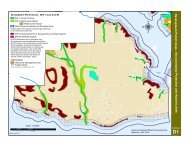
DPA 5 Steep Slopes - District of Sechelt
DPA 5 Steep Slopes - District of Sechelt
DPA 5 Steep Slopes - District of Sechelt

Create successful ePaper yourself
Turn your PDF publications into a flip-book with our unique Google optimized e-Paper software.
Guidelines<br />
Development Permits issued in <strong>DPA</strong> 5 will<br />
be in accordance with the following:<br />
1. No site disturbance, clearing,<br />
building, or other development <strong>of</strong><br />
land shall take place except in<br />
accordance with a development<br />
permit or specifically exempted by<br />
the <strong>District</strong>.<br />
2. Land with slopes over 30% is<br />
generally not suitable for residential<br />
development and development<br />
should be avoided. Development<br />
may be considered where it can be<br />
demonstrated that the proposed<br />
development will not create<br />
environmental or visual impacts, can<br />
be sensitively integrated with the<br />
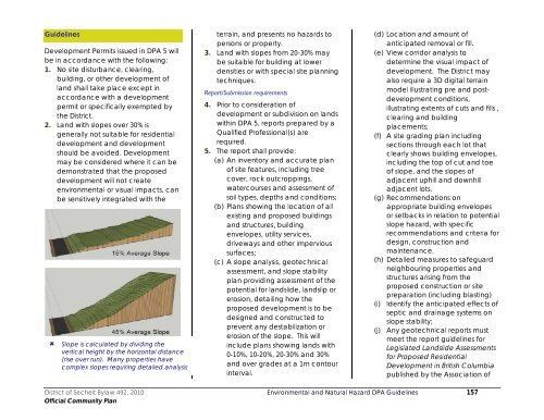
Slope is calculated by dividing the<br />
vertical height by the horizontal distance<br />
(rise over run). Many properties have<br />
complex slopes requiring detailed analysis<br />
terrain, and presents no hazards to<br />
persons or property.<br />
3. Land with slopes from 20-30% may<br />
be suitable for building at lower<br />
densities or with special site planning<br />
techniques.<br />
Report/Submission requirements<br />
4. Prior to consideration <strong>of</strong><br />
development or subdivision on lands<br />
within <strong>DPA</strong> 5, reports prepared by a<br />
Qualified Pr<strong>of</strong>essional(s) are<br />
required.<br />
5. The report shall provide:<br />
(a) An inventory and accurate plan<br />
<strong>of</strong> site features, including tree<br />
cover, rock outcroppings,<br />
watercourses and assessment <strong>of</strong><br />
soil types, depths and conditions;<br />
(b) Plans showing the location <strong>of</strong> all<br />
existing and proposed buildings<br />
and structures, building<br />
envelopes, utility services,<br />
driveways and other impervious<br />
surfaces;<br />
(c) A slope analysis, geotechnical<br />
assessment, and slope stability<br />
plan providing assessment <strong>of</strong> the<br />
potential for landslide, landslip or<br />
erosion, detailing how the<br />
proposed development is to be<br />
designed and constructed to<br />
prevent any destabilization or<br />
erosion <strong>of</strong> the slope. This will<br />
include plans showing lands with<br />
0-10%, 10-20%, 20-30% and 30%<br />
and over grades at a 1m contour<br />
interval.<br />
(d) Location and amount <strong>of</strong><br />
anticipated removal or fill.<br />
(e) View corridor analysis to<br />
determine the visual impact <strong>of</strong><br />
development. The <strong>District</strong> may<br />
also require a 3D digital terrain<br />
model illustrating pre and postdevelopment<br />
conditions,<br />
illustrating extents <strong>of</strong> cuts and fills ,<br />
clearing and building<br />
placements;<br />
(f) A site grading plan including<br />
sections through each lot that<br />
clearly shows building envelopes,<br />
including the top <strong>of</strong> cut and toe<br />
<strong>of</strong> slope, and the slopes <strong>of</strong><br />
adjacent uphill and downhill<br />
adjacent lots.<br />
(g) Recommendations on<br />
appropriate building envelopes<br />
or setbacks in relation to potential<br />
slope hazard, with specific<br />
recommendations and criteria for<br />
design, construction and<br />
maintenance.<br />
(h) Detailed measures to safeguard<br />
neighbouring properties and<br />
structures arising from the<br />
proposed construction or site<br />
preparation (including blasting)<br />
(i) Identify the anticipated effects <strong>of</strong><br />
septic and drainage systems on<br />
slope stability;<br />
(j) Any geotechnical reports must<br />
meet the report guidelines for<br />
Legislated Landslide Assessments<br />
for Proposed Residential<br />
Development in British Columbia<br />
published by the Association <strong>of</strong><br />
<strong>District</strong> <strong>of</strong> <strong>Sechelt</strong> Bylaw 492, 2010 Environmental and Natural Hazard <strong>DPA</strong> Guidelines 157<br />
Official Community Plan