CallForBidsNF00-1 - Jeanne d'Arc, South Whale, Magdalen Basins
CallForBidsNF00-1 - Jeanne d'Arc, South Whale, Magdalen Basins
CallForBidsNF00-1 - Jeanne d'Arc, South Whale, Magdalen Basins

You also want an ePaper? Increase the reach of your titles
YUMPU automatically turns print PDFs into web optimized ePapers that Google loves.
GEOLOGICAL FRAMEWORK<br />
PALEOZOIC MESOZOIC CENOZOIC<br />
CARBONIFEROUS TR. JURASSIC CRETACEOUS<br />
TERTIARY<br />
DEV.<br />
NEOG<br />
PALOEGENE<br />
SENONIAN<br />
M<br />
E<br />
L<br />
M<br />
L<br />
E<br />
L<br />
M<br />
OXFORDIAN<br />
CALLOVIAN<br />
BAJOCIAN<br />
BAJOCIAN<br />
TOARCIAN<br />
PLIENSBACHIAN<br />
SINEMURIAN<br />
HETTANGIAN<br />
RHAETIAN<br />
STEPHANIAN<br />
WESTPHALIAN<br />
NAMURIAN<br />
VISEAN<br />
TOURNAISIAN<br />
FAMENNIAN<br />
FRASNIAN<br />
GIVETIAN<br />
CANYON FM.<br />
VERRILL<br />
<br />
ABENAKI<br />
FM.<br />
MIC MAC<br />
FM.<br />
MOHAWK FM.<br />
IROQOUIS FM.<br />
ARGO FM.<br />
EURYDICE FM.<br />
ABENAKI<br />
FM<br />
SHALE<br />
IROQUOIS FM.<br />
ARGO FM.<br />
EURYDICE FM.<br />
UNNAMED<br />
PICTOU<br />
CUMBERLAND GPS.<br />
RIVERDALE-<br />
CANSO GPS.<br />
WINDSOR GP.<br />
HORTON GP.<br />
BASEMENT COMPLEX<br />
SHALE<br />
UPPER CARB<br />
LR. SHALE<br />
ARGO FM.<br />
MIC<br />
MAC<br />
FM.<br />
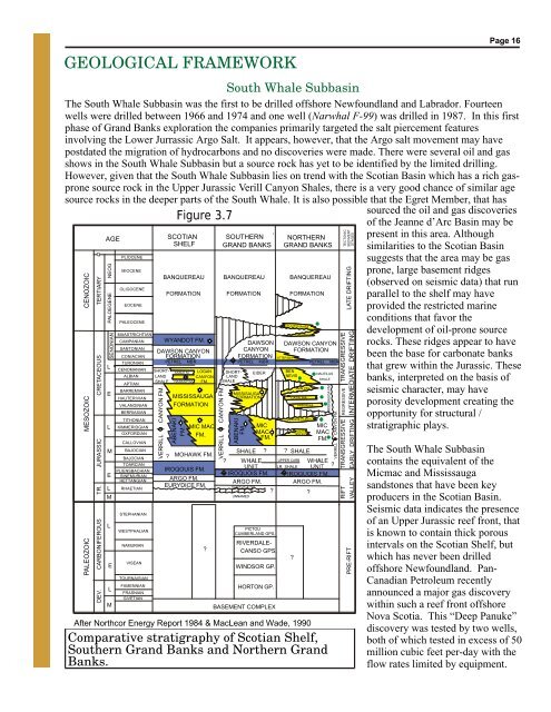
Comparative stratigraphy of Scotian Shelf,<br />
<strong>South</strong>ern Grand Banks and Northern Grand<br />
Banks.<br />
<br />
CANYON FM.<br />
VERRILL<br />
<br />
MIC<br />
MAC<br />
FM.<br />
<br />
SOUTH MARA<br />
<br />
<br />
SOUTH<br />
TEMPEST<br />
After Northcor Energy Report 1984 & MacLean and Wade, 1990<br />
MISSISAUGA FM.<br />
CANYON FM.<br />
VERRILL<br />
<br />
TRANSGRESSIVE<br />
REGRESSIVE<br />
INTERMEDIATE DRIFTING<br />
TRANSGRESSIVE<br />
RIFT<br />
TECTONIC<br />
SEDIMENT<br />
STAGES<br />
LATE DRIFTING<br />
EARLY DRIFTING<br />
VALLEY<br />
PRE-RIFT<br />
Page 16<br />
<strong>South</strong> <strong>Whale</strong> Subbasin<br />
The <strong>South</strong> <strong>Whale</strong> Subbasin was the first to be drilled offshore Newfoundland and Labrador. Fourteen<br />
wells were drilled between 1966 and 1974 and one well ( Narwhal F-99) was drilled in 1987. In this first<br />
phase of Grand Banks exploration the companies primarily targeted the salt piercement features<br />
involving the Lower Jurrassic Argo Salt. It appears, however, that the Argo salt movement may have<br />
postdated the migration of hydrocarbons and no discoveries were made. There were several oil and gas<br />
shows in the <strong>South</strong> <strong>Whale</strong> Subbasin but a source rock has yet to be identified by the limited drilling.<br />
However, given that the <strong>South</strong> <strong>Whale</strong> Subbasin lies on trend with the Scotian Basin which has a rich gasprone<br />
source rock in the Upper Jurassic Verill Canyon Shales, there is a very good chance of similar age<br />
source rocks in the deeper parts of the <strong>South</strong> <strong>Whale</strong>. It is also possible that the Egret Member, that has<br />
sourced the oil and gas discoveries<br />
Figure 3.7<br />
of the <strong>Jeanne</strong> d’Arc Basin may be<br />
AGE<br />
SCOTIAN SOUTHERN NORTHERN present in this area. Although<br />
SHELF GRAND BANKS GRAND BANKS similarities to the Scotian Basin<br />
Q<br />
PLIOCENE<br />
suggests that the area may be gas<br />
MIOCENE<br />
prone, large basement ridges<br />
BANQUEREAU BANQUEREAU BANQUEREAU<br />
(observed on seismic data) that run<br />
OLIGOCENE<br />
FORMATION FORMATION FORMATION parallel to the shelf may have<br />
EOCENE<br />
provided the restricted marine<br />
conditions that favor the<br />
PALEOCENE<br />
development of oil-prone source<br />
MAASTRICHTIAN<br />
FOX HARBOUR<br />
CAMPANIAN WYANDOT FM.<br />
DAWSON DAWSON CANYON rocks. These ridges appear to have<br />
SANTONIAN<br />
DAWSON CANYON<br />
CANYON FORMATION<br />
CONIACIAN FORMATION<br />
FORMATION<br />
been the base for carbonate banks<br />
OTTER BAY<br />
TURONIAN<br />
PETREL MBR<br />
PETREL MBR<br />
PETREL MBR<br />
L<br />
that grew within the Jurassic. These<br />
CENOMANIAN SHORT- SABLE M. LOGAN SHORT- EIDER<br />
BEN<br />
NAUTILUS<br />
ALBIAN LAND<br />
CANYON LAND<br />
NEVIS<br />
SHALE<br />
SHALE NASKAPI M. FM. SHALE<br />
banks, interpreted on the basis of<br />
APTIAN<br />
AVALON<br />
BARREMIAN<br />
seismic character, may have<br />
E<br />
MISSISAUGA<br />
HAUTERIVIAN MISSISSAUGA<br />
FORMATION<br />
CATALINA<br />
VALANGINIAN FORMATION<br />
porosity development creating the<br />
HIBERNIA<br />
BERRIASIAN<br />
opportunity for structural /<br />
TITHONIAN<br />
JEANNE D’ARC<br />
L KIMMERIDGIAN<br />
stratigraphic plays.<br />
The <strong>South</strong> <strong>Whale</strong> Subbasin<br />
contains the equivalent of the<br />
Micmac and Mississauga<br />
sandstones that have been key<br />
producers in the Scotian Basin.<br />
Seismic data indicates the presence<br />
of an Upper Jurassic reef front, that<br />
is known to contain thick porous<br />
intervals on the Scotian Shelf, but<br />
which has never been drilled<br />
offshore Newfoundland. Pan-<br />
Canadian Petroleum recently<br />
announced a major gas discovery<br />
within such a reef front offshore<br />
Nova Scotia. This “Deep Panuke”<br />
discovery was tested by two wells,<br />
both of which tested in excess of 50<br />
million cubic feet per-day with the<br />
flow rates limited by equipment.