CallForBidsNF00-1 - Jeanne d'Arc, South Whale, Magdalen Basins
CallForBidsNF00-1 - Jeanne d'Arc, South Whale, Magdalen Basins
CallForBidsNF00-1 - Jeanne d'Arc, South Whale, Magdalen Basins

You also want an ePaper? Increase the reach of your titles
YUMPU automatically turns print PDFs into web optimized ePapers that Google loves.
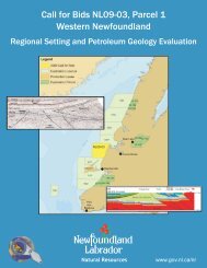
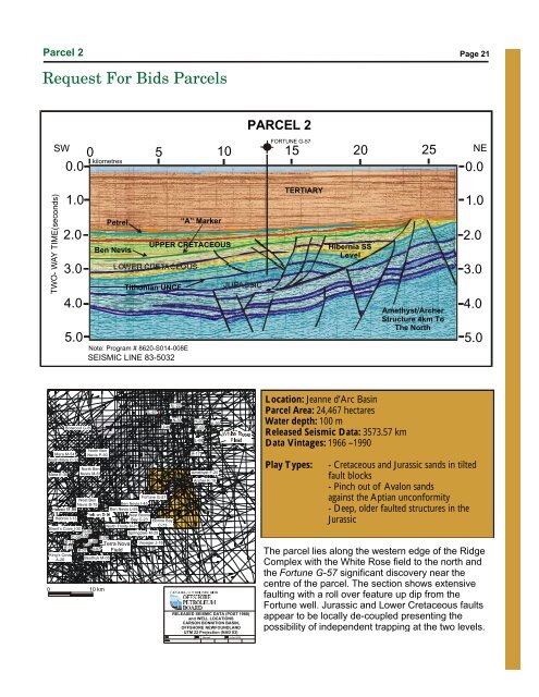
Parcel 2<br />
Page 21<br />
Request For Bids Parcels<br />
PARCEL 2<br />
SW<br />
FORTUNE G-57<br />
0 5 10 15 20 25<br />
kilometres<br />
0.0<br />
NE<br />
0.0<br />
O<br />
47 00’<br />
TWO- WAY TIME(seconds)<br />
O<br />
-48 40’<br />
1.0<br />
2.0<br />
3.0<br />
4.0<br />
5.0<br />
Adolphus D-50<br />
Petrel<br />
Ben Nevis<br />
UPPER CRETACEOUS<br />
LOWER CRETACEOUS<br />
Tithonian UNCF.<br />
Note: Program # 8620-S014-008E<br />
SEISMIC LINE 83-5032<br />
“A” Marker<br />
JURASSIC<br />
O<br />
-47 40’<br />
O<br />
47 00’<br />
TERTIARY<br />
Hibernia SS<br />
Level<br />
Amethyst/Archer<br />
Structure 4km To<br />
The North<br />
1.0<br />
2.0<br />
3.0<br />
4.0<br />
5.0<br />
Trave E-87<br />
Mara M-54<br />
<strong>South</strong> Mara C-13<br />
0<br />
Mara E-30<br />
Botwood G-89<br />
Hebron I-13<br />
North Ben<br />
Nevis P-93<br />
North Ben<br />
Nevis M-61<br />
West Ben<br />
Nevis B-75<br />
Brent’s Cove I-30<br />
G-90<br />
C-09<br />
H-99<br />
K-18 L-98<br />
K-08<br />
K-17<br />
K-07 I-97<br />
King’s Cove<br />
A-26<br />
E-79<br />
Beothuk M-05<br />
10 km<br />
# 1<br />
Ben Nevis I-45<br />
Ben Nevis L-55<br />
West Bonne<br />
Bay C-23<br />
North Trinity H-71<br />
Terra Nova<br />
Field<br />
L-61<br />
Fortune G-57<br />
Springdale M-29<br />
J-49<br />
Bonne Bay<br />
C-73<br />
Voyager J-18<br />
N -22<br />
N-30<br />
# 2<br />
H-20<br />
E-09<br />
L-08<br />
A-17<br />
A-90<br />
Amethyst F-20<br />
Archer K-19<br />
RELEASED SEISMIC DATA (POST 1980)<br />
and WELL LOCATIONS<br />
CARSON BONNITION BASIN,<br />
OFFSHORE NEWFOUNDLAND<br />
UTM 22 Projection (NAD 83)<br />
T. Bennett<br />
4-Apr-2000<br />
Location: <strong>Jeanne</strong> d’Arc Basin<br />
Parcel Area: 24,467 hectares<br />
Water depth: 100 m<br />
Released Seismic Data: 3573.57 km<br />
Data Vintages: 1966 –1990<br />
Play Types:<br />
The parcel lies along the western edge of the Ridge<br />
Complex with the White Rose field to the north and<br />
the Fortune G-57 significant discovery near the<br />
centre of the parcel. The section shows extensive<br />
faulting with a roll over feature up dip from the<br />
Fortune well. Jurassic and Lower Cretaceous faults<br />
appear to be locally de-coupled presenting the<br />
possibility of independent trapping at the two levels.<br />
O<br />
-47 40’<br />
O<br />
46 20’<br />
- Cretaceous and Jurassic sands in tilted<br />
fault blocks<br />
- Pinch out of Avalon sands<br />
against the Aptian unconformity<br />
- Deep, older faulted structures in the<br />
Jurassic