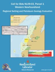
CallForBidsNF00-1 - Jeanne d'Arc, South Whale, Magdalen Basins
CallForBidsNF00-1 - Jeanne d'Arc, South Whale, Magdalen Basins
CallForBidsNF00-1 - Jeanne d'Arc, South Whale, Magdalen Basins

You also want an ePaper? Increase the reach of your titles
YUMPU automatically turns print PDFs into web optimized ePapers that Google loves.
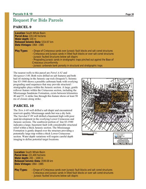
Parcels 9 & 10<br />
Request For Bids Parcels<br />
PARCEL 9<br />
Page 30<br />
Location: <strong>South</strong> <strong>Whale</strong> Basin<br />
Parcel Area: 220,140 hectares<br />
Water depth: 100 m<br />
Released Seismic Data: 5314.97 km<br />
Data Vintages: 1964 –1985<br />
Play Types: - Drape of Cretaceous sands over Jurassic fault blocks and salt cored structures<br />
- Cretaceous and Jurassic sands in tilted fault blocks or over salt cored structures<br />
- Jurassic faulted structures below salt diapirs<br />
- Prograding Jurassic sands in stratigraphic traps pinched out against the Base of<br />
Cretaceous unconformity<br />
- Jurassic carbonate bank porosity in structural and stratigraphic traps<br />
The nearest wells to this parcel are Petrel A-82 and<br />
Merganser I-80. Both were drilled on salt features and both<br />
had oil staining in the Jurassic cap rock (Iroquois). Seismic<br />
line 83-1940 shows a possible carbonate bank with overlying<br />
prograding sand sequences that may provide structural /<br />
stratigraphic plays within the Jurassic section. A large, gentle<br />
rollover feature within the Cretaceous section, including the<br />
Mississauga Sandstone Formation, exists between kilometres<br />
40 and 55. A strike line through this feature shows at least 50<br />
ms of closure along strike.<br />
O<br />
-55 00’<br />
O<br />
45 00’<br />
Kittiwake P-11<br />
Puffin B-90<br />
# 8<br />
Petrel A-62<br />
Gannet O-54<br />
# 9<br />
Razorbill F-54<br />
Merganser I-60<br />
O<br />
-52 00’<br />
O<br />
45 00’<br />
PARCEL 10<br />
The Tern A-68 well drilled a salt diapir and encountered<br />
reservoir quality Mississauga sands but was a dry hole.<br />
The Narwhal F-99 well drilled a basement high with poor<br />
sand development in the overlying Lower Cretaceous and<br />
Jurassic sections. The southwest portion of line 83-1940<br />
indicates a large, basement fault with considerable structural<br />
relief within a thick Jurassic section. The Mississauga<br />
Formation is gently draped over the structure providing a<br />
potentially large trap within a thick Lower Cretaceous<br />
section. Water depth variations will require careful depth<br />
imaging to define potential target locations.<br />
O<br />
44 00’<br />
0<br />
Narwhal F-99<br />
20 km<br />
Tern A-68 Shearwater J-20<br />
# 10<br />
# 11<br />
Brant P-87<br />
Gull F-72<br />
Heron H-73<br />
# 12 # 13<br />
Tors Cove<br />
D-52<br />
Heron<br />
J-72<br />
Mallard<br />
M-45<br />
RELEASED SEISMIC DATA (POST 1980)<br />
and WELL LOCATIONS<br />
CARSON BONNITION BASIN,<br />
OFFSHORE NEWFOUNDLAND<br />
UTM 22 Projection (NAD 83)<br />
O<br />
44 00’<br />
T. Bennett<br />
4-Apr-2000<br />
Location: <strong>South</strong> <strong>Whale</strong> Basin<br />
Parcel Area: 221,400 hectares<br />
Water depth: 200 – 1000 m<br />
Released Seismic Data: 3599.08 km<br />
Data Vintages: 1964 –1985<br />
O<br />
43 00’<br />
O<br />
-55 00’<br />
O<br />
-52 00’<br />
O<br />
43 00’<br />
Play Types: - Drape of Cretaceous sands over Jurassic fault blocks and salt cored structures<br />
- Cretaceous and Jurassic sands in tilted fault blocks or over salt cored structures<br />
- Jurassic faulted structures below salt diapirs