CallForBidsNF00-1 - Jeanne d'Arc, South Whale, Magdalen Basins
CallForBidsNF00-1 - Jeanne d'Arc, South Whale, Magdalen Basins
CallForBidsNF00-1 - Jeanne d'Arc, South Whale, Magdalen Basins

You also want an ePaper? Increase the reach of your titles
YUMPU automatically turns print PDFs into web optimized ePapers that Google loves.
4610’<br />
O<br />
45 0’<br />
O<br />
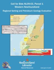
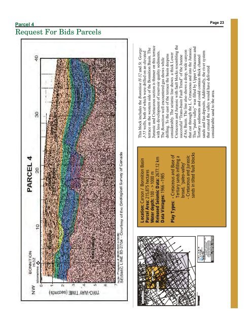
Parcel Parcel 4<br />
Request For Bids Parcels<br />
Page<br />
Page<br />
23<br />
23<br />
O<br />
-47 00’<br />
O<br />
-47 00’<br />
# 5<br />
# 7<br />
# 4<br />
# 6<br />
O<br />
-49 00’<br />
O<br />
46 10’<br />
Cormorant N-83<br />
Location: Carson / Bonnition Basin<br />
Parcel Area: 215,875 hectares<br />
Water depth: 100 - >1000 m<br />
Released Seismic Data: 2677.12 km<br />
Data Vintages: 1966 –1985<br />
Play Types: -<br />
Cretaceous and Base of<br />
Tertiary sands infilling a<br />
broad, ‘paleo-valley’<br />
- Cretaceous and Jurassic<br />
sands in tilted fault blocks<br />
This block includes the Bonnition H-32 and St. George<br />
J-55 wells, both of which were drilled on an elevated<br />
terrace on the western side of the Bonnition Basin. The<br />
Jurassic and Cretaceous section is thinner on this terrace<br />
with less development of reservoir quality sediments.<br />
The Bonnition well encountered gas shows while<br />
drilling. To the east of the terrace the basin deepens<br />
considerably. The seismic line shows a thick Lower<br />
Cretaceous and Jurassic with fault blocks resembling the<br />
successful “Trans-basin Fault Trend” of the <strong>Jeanne</strong><br />
<strong>d'Arc</strong> Basin. The line also shows a deep, wide canyon<br />
that cut through the L. Cretaceous and into the Jurassic.<br />
This “paleo valley” was filled by Upper Cretaceous and<br />
Tertiary sediments and could contain thick channel<br />
sands and fan deposits. Additionally, the river system<br />
that created the valley would have delivered<br />
considerable sand to the area.<br />
St. George J-55<br />
Skua E-41<br />
20 km<br />
O<br />
45 00’<br />
O<br />
-49 00’<br />
0<br />
RELEASED SEISMIC DATA (POST 1980)<br />
and WELL LOCATIONS<br />
CARSON BONNITION BASIN,<br />
OFFSHORE NEWFOUNDLAND<br />
UTM 22 Projection (NAD 83)<br />
T. Bennett<br />
4-Apr-2000