CallForBidsNF00-1 - Jeanne d'Arc, South Whale, Magdalen Basins
CallForBidsNF00-1 - Jeanne d'Arc, South Whale, Magdalen Basins
CallForBidsNF00-1 - Jeanne d'Arc, South Whale, Magdalen Basins

Create successful ePaper yourself
Turn your PDF publications into a flip-book with our unique Google optimized e-Paper software.
-5 2 0 0 ’<br />
O<br />
430’<br />
O<br />
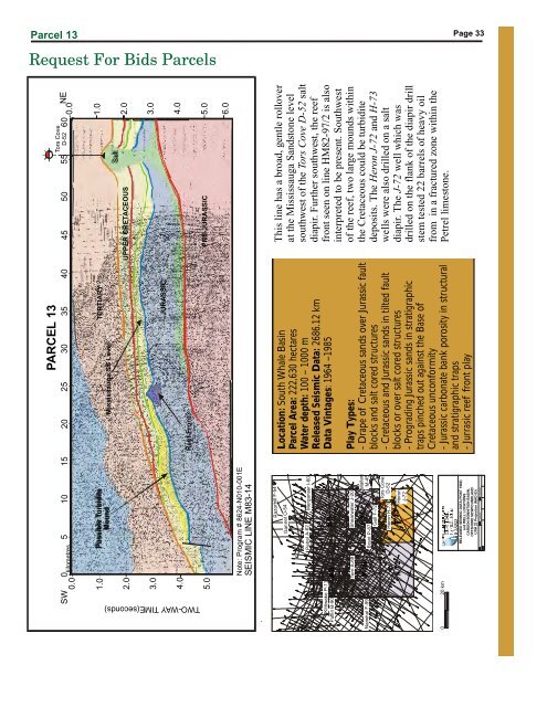
Parcel 13<br />
Request For Bids Parcels<br />
Page 33<br />
0.0<br />
1.0<br />
2.0<br />
3.0<br />
0 5 10 15 20 25 30 35 40 45 50 55 60<br />
kilometres<br />
Possible Turbidite<br />
Mound<br />
Mississauga SS Level<br />
PARCEL 13<br />
TERTIARY<br />
JURASSIC<br />
UPPER CRETACEOUS<br />
Salt<br />
Tors Cove<br />
D-52<br />
0.0<br />
1.0<br />
2.0<br />
3.0<br />
NE<br />
W O - A TIME(seconds)<br />
Y<br />
SWT<br />
4.0<br />
Reef Front<br />
4.0<br />
5.0<br />
PRE-JURASSIC<br />
5.0<br />
6.0<br />
6.0<br />
O<br />
-5200’<br />
Note: Program #8624-N010-001E<br />
SEISMIC LINE M83-14<br />
O<br />
45 00’<br />
#8<br />
#10<br />
GanetŌ54<br />
PetrelĀ62 Merganser I-60<br />
#9<br />
Kittiwake P-11<br />
Puffin B-90<br />
#1<br />
Narwhal F-99<br />
Tern A-68 Shearwater J-20<br />
Brant P-87<br />
Gull F-72<br />
Tors Cove<br />
D-52<br />
O<br />
44 00’<br />
#12 #13<br />
RazorbilF-54<br />
Malard<br />
M-45<br />
0<br />
20 km<br />
Note: Program # 8624-N010-001E<br />
SEISMIC LINE M83-14<br />
Heron H-73<br />
Heron<br />
J-72<br />
RELEASED SEISMIC DATA (POST 1980)<br />
and WELL LOCATIONS<br />
CARSON BONNITION BASIN,<br />
OFFSHORE NEWFOUNDLAND<br />
UTM 22 Projection (NAD 83)<br />
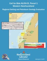
Location: <strong>South</strong> <strong>Whale</strong> Basin<br />
Parcel Area: 222,630 hectares<br />
Water depth: 100 – 1000 m<br />
Released Seismic Data: 2686.12 km<br />
Data Vintages : 1964 –1985<br />
Play Types:<br />
- Drape of Cretaceous sands over Jurassic fault<br />
blocks and salt cored structures<br />
- Cretaceous and Jurassic sands in tilted fault<br />
blocks or over salt cored structures<br />
- Prograding Jurassic sands in stratigraphic<br />
traps pinched out against the Base of<br />
Cretaceous unconformity<br />
- Jurassic carbonate bank porosity in structural<br />
and stratigraphic traps<br />
- Jurrasic reef front play<br />
This line has a broad, gentle rollover<br />
at the Mississauga Sandstone level<br />
southwest of the Tors Cove D-52 salt<br />
diapir. Further southwest, the reef<br />
front seen on line HM82-97/2 is also<br />
interpreted to be present. <strong>South</strong>west<br />
of the reef, two large mounds within<br />
the Cretaceous could be turbidite<br />
deposits. The Heron J-72 and H-73<br />
wells were also drilled on a salt<br />
diapir. The J-72 well which was<br />
drilled on the flank of the diapir drill<br />
stem tested 22 barrels of heavy oil<br />
from in a fractured zone within the<br />
Petrel limestone.<br />
T. Bennett<br />
4-Apr-2000<br />
O<br />
-55 00’