CallForBidsNF00-1 - Jeanne d'Arc, South Whale, Magdalen Basins
CallForBidsNF00-1 - Jeanne d'Arc, South Whale, Magdalen Basins
CallForBidsNF00-1 - Jeanne d'Arc, South Whale, Magdalen Basins

Create successful ePaper yourself
Turn your PDF publications into a flip-book with our unique Google optimized e-Paper software.
L o n g R a n g e A -0 9<br />
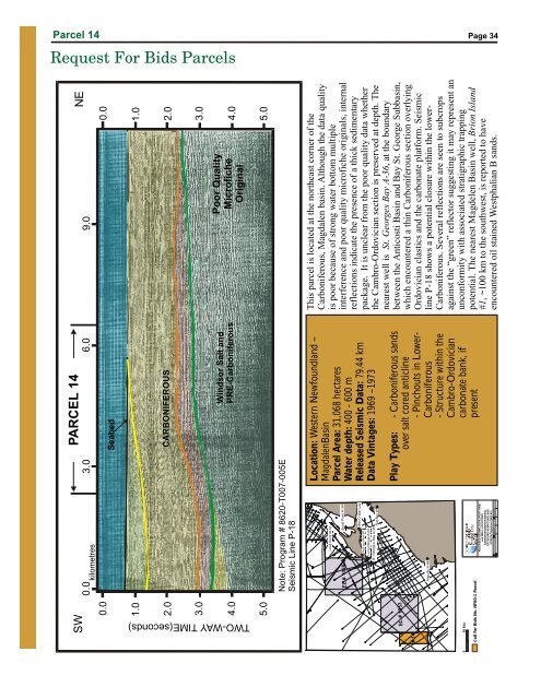
Parcel 14<br />
Page 34<br />
Request For Bids Parcels<br />
SW PARCEL 14<br />
NE<br />
0<br />
0.0 3.0 6.0 9.0<br />
0.0<br />
1.0<br />
Seabed<br />
CARBONIFEROUS<br />
0.0<br />
1.0<br />
2.0<br />
Windsor Salt and<br />
PRE-Carboniferous<br />
Poor Quality<br />
Microfiche<br />
Original<br />
2.0<br />
3.0<br />
3.0<br />
4.0<br />
kilometres<br />
4.0<br />
TWO-WAYTIME(seconds)<br />
5.0<br />
5.0<br />
Note: Program # 8620-T007-005E<br />
Seismic Line P-18<br />
10 Km<br />
Call For Bids No. NF00-1 Parcel<br />
This parcel is located at the northeast corner of the<br />
Carboniferous, <strong>Magdalen</strong> basin. Although the data quality<br />
is poor because of strong water bottom multiple<br />
interference and poor quality microfiche originals, internal<br />
reflections indicate the presence of a thick sedimentary<br />
package. It is unclear from the poor quality data whether<br />
the Cambro-Ordovician section is preserved at depth. The<br />
nearest well is St. Georges Bay A-36 , at the boundary<br />
Long Point M-16<br />
EL#1028<br />
ShoalPointK-39<br />
Man O War I-42<br />
Port au Port #1<br />
St. George’s Bay A-36<br />
between the Anticosti Basin and Bay St. George Subbasin,<br />
which encountered a thin Carboniferous section overlying<br />
Ordovician clastics and the carbonate platform. Seismic<br />
line P-18 shows a potential closure within the lower-<br />
Carboniferous. Several reflections are seen to subcrops<br />
#14<br />
EL#1053<br />
Anguille H-98<br />
against the “green” reflector suggesting it may represent an<br />
unconformity with associated stratigraphic trapping<br />
potential. The nearest Magdelen Basin well, Brion Island<br />
#1 , ~100 km to the southwest, is reported to have<br />
encountered oil stained Westphalian B sands.<br />
-6030' O -5930'<br />
O<br />
RELEASED SEISMIC DATA (POST 1980)<br />
and WELL LOCATIONS<br />
CARSON BONNITION BASIN,<br />
OFFSHORE NEWFOUNDLAND<br />
UTM 22 Projection (NAD 83)<br />
T. Bennett<br />
Flat Bay #1<br />
4-Apr-2000<br />
O<br />
-58 30’<br />
Location: Western Newfoundland –<br />
<strong>Magdalen</strong>Basin<br />
Parcel Area: 31,068 hectares<br />
Water depth: 400 - 600 m<br />
Released Seismic Data: 79.44 km<br />
Data Vintages: 1969 –1973<br />
Play Types: - Carboniferous sands<br />
over salt cored anticline<br />
- Pinchouts in Lower-<br />
Carboniferous<br />
- Structure within the<br />
Cambro-Ordovician<br />
carbonate bank, if<br />
present