

Bulletin 58. NJ Geodetic Control Survey Bench Marks in ...
Bulletin 58. NJ Geodetic Control Survey Bench Marks in ...
Bulletin 58. NJ Geodetic Control Survey Bench Marks in ...

Create successful ePaper yourself
Turn your PDF publications into a flip-book with our unique Google optimized e-Paper software.
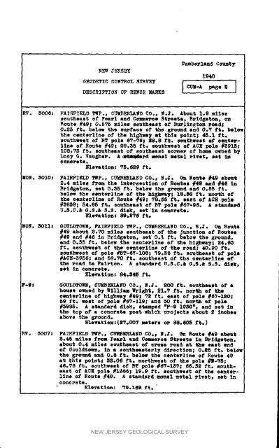
Cumberland<br />
County<br />
1940<br />
_EOD_YC C0_0L 5U_V_T [ _le-A _ge _ ]<br />
DESCRI_ION OF B_CH _S<br />
_V. 3006! FAIRFIELD Ttp., CU_BEB_ND CO., W.J. About 1_9 miles<br />
_outheaa_ of Pearl and Coz_oree St_ee_i, B_dgQton, on<br />
Route #4_; 0.575 miles southeast ef Bu_l<strong>in</strong>gton road;<br />
0.25 ft° bel_ the surfm©e of _he _ound and 0.7 ft. belol<br />
_he oenterltne of the hlghwa_ it thim po<strong>in</strong>t; 45.1 f_.<br />
_ou_hwes_ of BT pole 6?-96; 28.8 tt. southwei¢ of oenter-<br />
1In# of Route _4g_ 29.35 ft. gouthwem_ ot ACE pole #3913;<br />
108.73 f_. southeast of 8outheae_ corner o£ hm owned b7<br />
Luo 7 G. VauSher. A _Nmda_d m#l metal _lve_, met <strong>in</strong><br />
Eleva_ton_ 75.6_9 ft.<br />
_ON. 3010: FAIRFIELD TWP., CU_8_L_D CO°_ _.J° On Ron_e #49 abou_<br />
_._ mlle_ from the lote_-seetlon of Rou_e_ #4e and #46 <strong>in</strong><br />
B_td_e_n, _e_ 0°35 f_° bel_ _be g_vc, ud and 0.5_ f_.<br />
below the eent_ltne of _ho hl_h_ 1_°_ f_o no_h ot<br />
_he een_e_ltne of Rou_e #49; _8°_8 _t° eaat of ACE pole<br />
#_9_9; 54.95 f_. aou_heast ot BT pole #67°96. A itanda_d<br />
U.S°C.& G.S°& _.$. dlsk_ se_ <strong>in</strong> ¢oue_e_e.<br />
Ele_a_lon_ 89._7_ f_<br />
MON. 3011_ OOULDTOWN, FAIRFIELD TWp._ CUmBErLAnD _0°_ _._. On Rou_e<br />
#49 abou_ 2.70 mtleB southeast of the Junction ot Rom_ee<br />
#49 and #46 <strong>in</strong> Brld_e_en, ae_ 0.1 _° below _he g_ound,<br />
and 0.35 _t° below the cen_e_l<strong>in</strong>e of _he highway; 24.60<br />
ft. southwest of _he ¢en_e_l<strong>in</strong>e o_ _he _oad; 40.90 £_.<br />
southwest of pole #BT-_-_08; _9._6 ft. sou_heas_ o£ pole<br />
#ACE-_956; and <strong>58.</strong>70 ft. southeast o_ the oen_e_llne Ot<br />
_ha<br />
8e_<br />
_oad _ Fairton.<br />
In _on_e_e°<br />
A stan4a_d U.S.C.& G._.& 8.S. _i_k,<br />
Ele_a_lonx 84.348 f_.<br />
P-_ GOU_D_OWN, CUMB_I£ND CO.. _°Jo 200 _° southtl_ ot •<br />
house owned b 7 _111iam Wright, 21._ f_° north ef t_<br />
oen_e_ltne o_ hi_hn_ #491 72 ft° eas_ of pole #87-120;<br />
89 ft. wear of pole #6_-119; and 30 _t, north ot p_le<br />
#3995. A standard disk_ stamped "F-9 19_0", and set <strong>in</strong><br />
_he top of a conc_et4 po_t _hlch _o_eo_s abou_ 2 <strong>in</strong>ehe_<br />
above the _rouud°<br />
Bllwatlon_(_V°O07 m_te_e o_ 88.eOS f_°)<br />
_° 3007z FAIRFIELD T_P., CUMBERLAND CO_ _°J° On Route #49 abemt<br />
• °4_ mil_s f_ Pemel and Cme_oe _t_ee_s <strong>in</strong> B_idge_n,<br />
abou_ 0.4 miles sou_heaet o_ _o_ _oad a_ _he e_at e_d<br />
of Oouldtoen, <strong>in</strong> a _utheasterly d_ectlon; 0.£_ ft. _eIow<br />
the _-ound and 0.6 ft. belo_ the cen_erl<strong>in</strong>e of Route 49<br />
at _his po<strong>in</strong>t_ 32.0_ _t. northwest of the pole #B-VS;<br />
46.76 ft. aouthwe_t ot BT pole #_7-1_?; _6.32 ft, sou_heamt<br />
o_ ACE _ole #1866_ 19.9 it. southwest of the oente_<br />
l<strong>in</strong>e o_ Rou_e #49. A standard m_uel _et_l _lv_t, se_ _n<br />
Elevation: _9.169 ft.<br />
NEW JERSEY GEOLOGICAL SURVEY


