Bulletin 58. NJ Geodetic Control Survey Bench Marks in ...
Bulletin 58. NJ Geodetic Control Survey Bench Marks in ...
Bulletin 58. NJ Geodetic Control Survey Bench Marks in ...
Create successful ePaper yourself
Turn your PDF publications into a flip-book with our unique Google optimized e-Paper software.
RE_3_SEY<br />
Cumberland<br />
1QgN<br />
County<br />
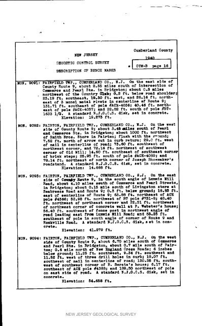
_EODETIC CORTROL SURVEY el CUE_ B page iS I<br />
DESCRIPTION OP BENCH MARKS<br />
ROE. 90el: FAIRFIELD TWP. w CU_ENEARO CO., N.I. On the east elde of<br />
County Route 9, about 2.35 miles south of <strong>in</strong>terseotlon of<br />
Cow,eros and Pearl Sis. In Brldgeton; about 0.3 miles<br />
. northwest of the Country C'_Uk| @.2 ft. below road shoulder<br />
25.19 ft. southeast, 19.30 ft. east, and 26.16 ft. northeast<br />
of 3 monel xe_al r_vets <strong>in</strong> _snterl<strong>in</strong>e e[ Rou_e O;<br />
151.71 ft. southeast of pole #AOk-40S6,- 40.46 ft. n_theast<br />
Of pole #ACE-4057; and 2S.$2 ft. south of pole #BT-<br />
1655 I/S. A standard N.3.G.C.3. disk, set <strong>in</strong> eonorete.<br />
Elevation: 19.27S ft.<br />
NON. 9092: FAIRTON, FAIRFIELD TWp., CUMBERLAND CO., R.J. On the west<br />
side of Count 7 Route 9; about 5.gg_lee louth of Pear1<br />
and Ceq_eroe Sis. <strong>in</strong> Brld_eton; about i000 ft. northwest<br />
of Smith Bros. Store <strong>in</strong> Fairten; flush with the _u_d;<br />
7.5S ft. north of arrow OUt In curb _et_; 29.0 ft, west<br />
of nell <strong>in</strong> eenterllne of Feed; 73.60 ft. southwest of<br />
northwest oorner, and _2.16 ft. northwest of southwest<br />
eerner of Old Mill; 14.90 ft. eoqtheast of southeast corner<br />
of brlek steps; 25.95 ft. south of pole #ACE-4Og9; and<br />
78.14 ft. northeast of north oo_e_ of Joseph Shoo,maker's<br />
roadstand. A standard N.I.G.C.S. diskp set <strong>in</strong> oonerete.<br />
Elevation: 14.668 ft.<br />
MON. 9098: FAIRTO_, _AIRPIELD TWP._ CUMP_RLABD CO., g.3. On the east<br />
side of C_ Reute 9, <strong>in</strong> the south angle of I_,ls Mill<br />
Read, ebo_t 4.10 roiled _euth of C_.eroe and Pearl Streets,<br />
<strong>in</strong> B_Id_eton,- about 0.15 mile sc_th of Livlngeton store at<br />
Seabreeze Road and Route g; 0_3 ft. below _T_md; 18°_ ft.<br />
east of senterllne of Route 9, 6_.88 ft. northeast of ACE<br />
pole #4366; 52.98 ft. northwest of BT pole #751-8; 48.40<br />
ft. noythvost Of northeast eoi_se_ and 22._I ft. noP_eet<br />
of northwest corner of eonorete wall at P. Webster_s house I<br />
56.40 ft. southwest of fenoe post <strong>in</strong> northwest angle of<br />
road lead<strong>in</strong>g east from Lummis Rill Road, and 85.25 ft.<br />
southeast of pole <strong>in</strong> south angle of eo_ne_ of Route 9 and<br />
Eoekvllle Road. A standard _._.O.C.S. dlek_ set <strong>in</strong> constets.<br />
Elevation: 41oS79 ft.<br />
EON. 9094: FAIRTO_, FAIRFIELD TWP., CUmBERLAnD CO., L_. On the west<br />
s_e of County Route 9_ about 6._0 miles south of C¢_eroe<br />
and Pearl Rts. <strong>in</strong> Brfdgeton, about 0.7 m/le south of Fairten;<br />
O.S mile no_th ef New England Cross Roads; 6 <strong>in</strong>ehes<br />
below ground_ 11o_5 ft. southwest, 9.34 ft. southwest and<br />
11.52 ft. vest of three drill holes In ou_b; 19.07 ft.<br />
southwest of nell <strong>in</strong> oenterllne of road; i_0.55 ft. southwest<br />
of southwest corner of Ro 3e_ata_s house; g.17 ft.<br />
southeast of ACE pole #4588; and 189.50 northwest of pole<br />
on east side of road. A standard R._.G.C.S. disk, set <strong>in</strong><br />
oonorote.<br />
Elevation: 54.658 ft.<br />
NEW JERSEY GEOLOGICAL SURVEY


