Bulletin 58. NJ Geodetic Control Survey Bench Marks in ...
Bulletin 58. NJ Geodetic Control Survey Bench Marks in ...
Bulletin 58. NJ Geodetic Control Survey Bench Marks in ...
You also want an ePaper? Increase the reach of your titles
YUMPU automatically turns print PDFs into web optimized ePapers that Google loves.
NEW .T_SEY<br />
GEODETEC CONTROL SURVEY<br />
DESCRIPTION OF BENCH MARKS<br />
C_berland CO.<br />
1942<br />
I CUM-A Page 16 1<br />
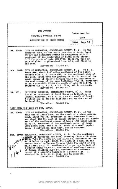
MK. 9062: CITY OF BRIDGETON, CUMBERLAND COUNTY, N. _o In the<br />
concrete eurb, at the south Junction of North Pearl<br />
Street end Rossnhayn Avenue <strong>in</strong> Bridgeton; 20,0 ft.<br />
southeast of the centerl<strong>in</strong>e of North Pearl Street;<br />
d.73 ft. north of pole ACE E796; 40°50 ft. west of<br />
pole BT#144. A galvanized iron bolt, set flush <strong>in</strong><br />
the curb.<br />
Elevation: V_.725 ft.<br />
MON* _06_: CITY OF HRIDGETON_ CUMBERLAND COUNTY, N. J. On S. H.<br />
Route #46, about 1.8E miles northeast of its <strong>in</strong>tersection<br />
with S. H. Route #49; on the northwest side of<br />
the road, flush with the 6round; 24.69 ft. 8outh of the<br />
south corner of Olsen,_ Garage; 62.35 ft. southwest of<br />
the east corner of the same build<strong>in</strong>g; 47.0 ft, northeast<br />
of pole ACE-_g35; 57._8 ft. north of pole ST 3-1474. A<br />
standard E.S°C. & G.S. & $°S. disk, set <strong>in</strong> concrete.<br />
Elevation: _,561 ft.<br />
RV. 131: BRIDGETCN JUNCTION, CUMBERLAND COUNTY, N_ J. About<br />
S.4 miles northeast of Court _ouse at Bridget6n , on<br />
Central Railroad, st M.P. 131; 45 ft. north of track,<br />
A raised lu6 on base of mile post set by the Central<br />
Railroad Co.<br />
Elevation: 8_.466 ft.<br />
LOOP RUN: G-9 1930 TO MON. l_Olfl.<br />
_. 6064: CITY OF BRIDGETON, CUMBERLAND COUNTY, N. J. At the<br />
dead end of Lemon Lane, on the crest of a steep embankmerit,<br />
about 750 ft. southeast of East Comme_oe Street<br />
and about 150 ft. east of Oranse S_reet; 44.64 ft. northeast<br />
of the northeast corner of house (#S_ Lemon Lane);<br />
29.58 f%. southeast of the southeast corner of house<br />
(#24 Lemon Lane) and 5.55 ft. south of a small poplar<br />
tree, A Ealvanlzed Ir_m bolt, set <strong>in</strong> concrete.<br />
Elevatlen: NSo 685 ft.<br />
MON. IEOIS:BS.'BR_/)GETON, CUMBERLAND COUNTY, N. J. On the southwest<br />
t_T%Q_ncr of 3efferson a_d Pearl Streeta; flush with side.<br />
_"_-_°_%_,7°04 ft. south of, and 10.69 ft. southwest of two<br />
_.,_ _drill holes <strong>in</strong> curb; 28.71 ft° south cf a nell <strong>in</strong> the<br />
[ • % centerl<strong>in</strong>e of Jefferson Street; II.55 ft. south of ACE<br />
i_ pole 1588; I_._I ft. southeast of cross cut <strong>in</strong> base of<br />
a street sign; 88.65 ft. northeast of northeast corner<br />
corner _f a co.crete block with a Texaco sig_. A<br />
i_ _ of atar_sN Texaco N. Statlon; Elevation: J. G. C. _._5 S, ft. dl_k, 10.289 no,thwe,t sat ft, <strong>in</strong> concrete. of no,thwest<br />
NEW JERSEY GEOLOGICAL SURVEY


