

Bulletin 58. NJ Geodetic Control Survey Bench Marks in ...
Bulletin 58. NJ Geodetic Control Survey Bench Marks in ...
Bulletin 58. NJ Geodetic Control Survey Bench Marks in ...

Create successful ePaper yourself
Turn your PDF publications into a flip-book with our unique Google optimized e-Paper software.
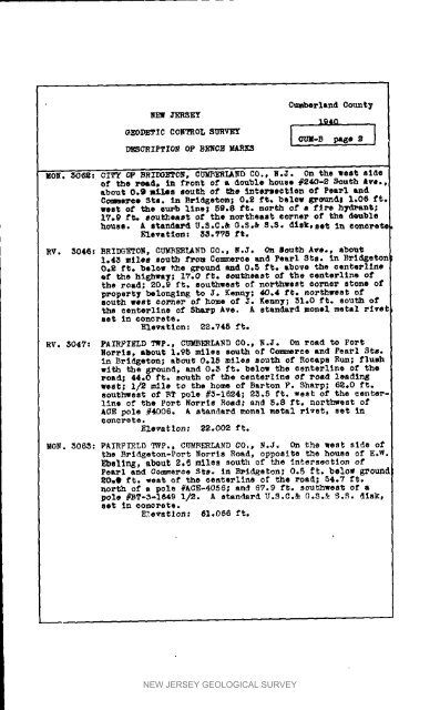
NEW 3ER8EY<br />
Cmabe_-land<br />
lg40<br />
0ount_<br />
_EOIYET_C C0NTROL SURVEY I CUM.B pase , I<br />
DNSCRIPTION OP B_C2 N<br />
UOg. 3062: CITY OF BRII_0N, C_E_ND C0., N.3* On the west side<br />
of the read_ <strong>in</strong> front of a double house #240-2 South ave..<br />
about 0.9 Lil.os south of the tntsx_ectten of Pearl and<br />
Cc_Re_ee Sta. In Brtdgeton,-o 0.2 ft. below _mmdl 1.06 ft.<br />
west of the euz, b l<strong>in</strong>e; 59.8 ft. north of a fire hTd_S_t;<br />
1_.9 ft_ southeast of the northeast ee_ner of the d_uble<br />
house. A standard U.S.C._ O.s._ _,S. disk. set <strong>in</strong> eoneeet_<br />
Elevation: 33._5 ft,<br />
RV. 3046: BRIDGETON, gUMBERLAND GO.p N.3. On _outh Ave., about<br />
1.4_ mllem south f_om Co_erse and Pearl Sis. <strong>in</strong> Bri_etoI<br />
0.2 ft. below the _ound and 0._ ft. above the eenterl<strong>in</strong>e<br />
ef the highway; 1T.O ft. southeast of the centerltne of<br />
the road; 20.9 ft. southwest of noethwest oorne_ stone of<br />
propel'ty belonstng to 3. Kenn7; 40.4 ft. northwest of<br />
South west corner of home of 3. Kenny; _1.0 ft. sou_h of<br />
the centerllne of Sharp Ave. A standard monel metal rivel<br />
set <strong>in</strong> concrete.<br />
Elevat_on: _2oV48 ft.<br />
RV. 5047: FAIRFIELD _P., CUMB_LARD CO., B._. On _oad to Port<br />
Norris, about 1._5 miles south of Coz_erce and PeeP1 Sts.<br />
In Brid_eton; about O.15 miles so_th o_ Recaps Run; flush<br />
• ith the 8_ound. and 0.3 ft. below the eenterl<strong>in</strong>s of the<br />
Poad; 44°0 ft. south of the centePltne of Poad lead<strong>in</strong>_<br />
west; 1/_ mile to the home of Barton F. Sharp; 6_.O ft.<br />
southwest of _T pole #5-1624; 2_°5 tt. west of the oenterl<strong>in</strong>e<br />
o_ the Po_t Norris Road; and 5.8 ft. northwest of<br />
ACE pole #4006° _ standard monel metal rivet_ set <strong>in</strong><br />
(_onorete.<br />
Elevation: _2.002 ft.<br />
MON. 3063: PA_BPI_LD T_P., CUmbErLAND CO., N._. On the west slde o_<br />
the B_id_eton-Port Norris Road, opposite the house of E.W.<br />
Ebelln_, abeu_ 2._ miles south o_ the Interseotlon of<br />
Pe_l and Com_e_e StSo <strong>in</strong> BPidEeton; 0.5 _. below _ou_d<br />
_0.@ _t. west of the ee_te_llne o_ the _oad; 54.7 ft,<br />
north of a pole #ACE-dOS6; and _v.9 l't. southwest o_ a<br />
pole #_T-5-1849 1/2. A standard U.S.C.& G.S._ _.R. disk,<br />
set <strong>in</strong> concrete.<br />
E_evatlo_: 61o066 ft.<br />
NEW JERSEY GEOLOGICAL SURVEY


