Bulletin 58. NJ Geodetic Control Survey Bench Marks in ...
Bulletin 58. NJ Geodetic Control Survey Bench Marks in ...
Bulletin 58. NJ Geodetic Control Survey Bench Marks in ...
You also want an ePaper? Increase the reach of your titles
YUMPU automatically turns print PDFs into web optimized ePapers that Google loves.
NEW _SEY<br />
C_berl_d<br />
Y940<br />
C0unty<br />
OEODETIC CONTROL 8u.v_Y [CIPM-B page 8 1<br />
DESCRIPTION OF BENCH _R_S<br />
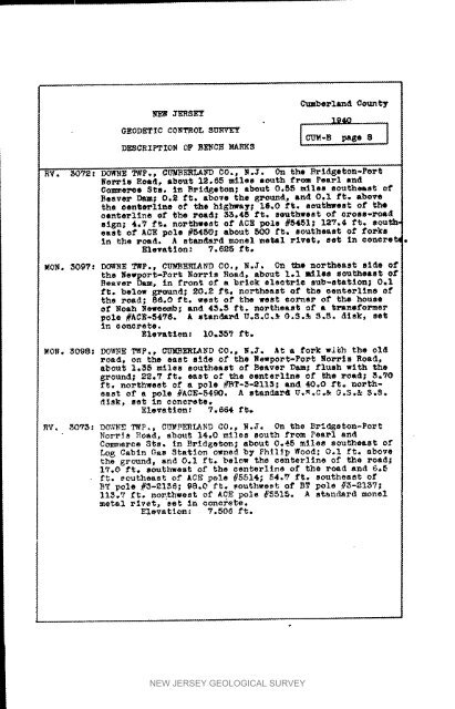
RV. _072: DOWNE TWP,, CUMBERLA_ CO., _.J. On the Brl_eton-Port<br />
_O_TIS Roedt abo_t 12.65 miles mc_th f_om Pearl Ind<br />
Commerce Sis. <strong>in</strong> Brld_eton; about 0.65 miles southeast of<br />
Beaver Dam; 0,_ ft* stove the grou_te anl 0,I ft. above<br />
the oente_llne of the hlghwaT; 16,0 ft. se_thwest of<br />
oanterl<strong>in</strong>e of the road; <strong>58.</strong>45 ft. mouthweet of cross-foal<br />
sign; 4.7 ft. northwest of ACE pole #5451; 18V.4 ft, sou_h<br />
esst of ACE pole #5450; abou_ 500 ft, southeast of forks<br />
<strong>in</strong> the roa_. A steward monel _etal rivet, set In conere_<br />
Elevation: ?.6_5 ft.<br />
_o_. _097: now_ _P., CU_ER_A_D CO., _._. On _e northeast slde of<br />
the _s,rpo_t-Por_<br />
Beaver Dam, <strong>in</strong><br />
_orris<br />
front of<br />
Road, about 1.1miles southeast<br />
a _niok elee_rie sub-station,<br />
of<br />
0.1<br />
ft. below f_.eond; 20._ ft. no_heest of the eenterl<strong>in</strong>e of<br />
the read; 86.0 ft. west of the west eorner of the house<br />
of _oah _e_eo_h; and 45.3 ft. southeast of • t_aaeformer<br />
pole #ACE-5476. k stsn_d U.S,C,& 0.8._ S._. disk, set<br />
<strong>in</strong> concrete.<br />
Elevation: 10,557 ft.<br />
MONo 5098: DO_VNET_P., _UM_ERL_ND CO., 8._. _t a fork wi_h the old<br />
road, on the east s_de Of the _ewpo_t-Port No_28 Road,<br />
about 1.55 miles southeast of Beaver Dam; flush wlth the<br />
ground; 22.? ft. sa_t of _e esnte_lfne of She road; _.90<br />
ft. northwest of a pole #BT-3-2118; and 40.0 ft. northeast<br />
of a pole #ACE-54_O. A standard U._.C.& O.8.& 6.8.<br />
disk, set <strong>in</strong> concrete.<br />
Elevation: 7.564 ft.<br />
_V. 8078: D_N_ T_P., CUMbErlAND CO., N._, On the Brid_eton-Port<br />
Norris _oad. about 14.0 mi_es south from Pes_l and<br />
C_eree Sis. tn Brid_eton; about 0,_6 mi_ee _ou_heast of<br />
_o_ Cab<strong>in</strong> Gas Station owned by Ph_t_p Wood_ O.1 ft. above<br />
the _ound, and 0.I ft. belo_ the _enterllne of the road;<br />
17.0 ft. southwest of the csnterl<strong>in</strong>e of the road end 6.6<br />
• ft. southeast of ACE pole #5514; 54._ f_. southeast of<br />
BT pole #_-_I_6; 88.0 f_. _outh_eet of BT pole #_-21_7;<br />
l13,V £_. nor:thwest of ACE pole _5515. A standard monel<br />
metal rivet, eat <strong>in</strong> concrete.<br />
Elevation: 7.506 ft.<br />
NEW JERSEY GEOLOGICAL SURVEY


