Bulletin 58. NJ Geodetic Control Survey Bench Marks in ...
Bulletin 58. NJ Geodetic Control Survey Bench Marks in ...
Bulletin 58. NJ Geodetic Control Survey Bench Marks in ...
Create successful ePaper yourself
Turn your PDF publications into a flip-book with our unique Google optimized e-Paper software.
R_'__sL'Y<br />
Cumberland Coun_*_r<br />
_Le40<br />
C;_OD_'TZCCO_'tRO_S_V_'Y I COM.R .ge g I<br />
DE3CRIPTION OF BENC_ MARKS<br />
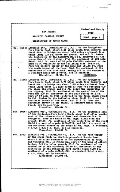
Port NO.Pie Road, about 8°g5 miles south from Oommerca and<br />
Pearl Sts. <strong>in</strong> Bridgeton; about 1.15 miles southeast f_om<br />
Cedar Lake; 0.£ ft. above the ground, and 0ol ft. below<br />
the tenterllne el" the hi_hlmy; 20.4 ft. southwest of the<br />
centerl<strong>in</strong>e of the h_hway; 2V.6 ft. southeast of ACE pole<br />
..... _4935; 56.5 ft. south of BT pole #3-1695; _efez'Ped to the<br />
home of D, _¢_lleimo by the follewlng ties: 104o0 ft°<br />
fl"om the western corner- of the home and 134._5 ft. Drom<br />
the south sol"net of the,home; 55°8 ft. sout_east of the<br />
centerllne of the dirt road leadlng off to the southwest.<br />
A e_anda_d monel metal _ivet, set <strong>in</strong> concrete.<br />
Elevatlon: 31.914 ft. DESTROYED.<br />
_Vo 3065: LAWRENCE TWp., CU_ERIAND CO., R.J. On the BP1dgeton-<br />
Per% Norris Road, about 8.75 miles sou.th fr¢_l _o_e_ea and<br />
Pea_l Sis. In Rrld_eton; about 1.65 miles southeast f_om<br />
Ce_ Lake; about O._L m11e north of G_II_ Gas Station; O, °<br />
f_;o shove the gronnd and O.S ft. below the _enterl_na of'<br />
the highway; 82.3 ft. southwest of _he eenterllne of the<br />
road and 4.9 ft. northwest of ACE pole #4972; 56.1 ft.<br />
west of RT pole #5-1915; refe_l'ed t;o the flame shack owned<br />
b_ C.F. Ma_hew by the followln6 ties: 56.95 ft. f_om the<br />
northeast ¢o_ne_ of the s_ek, and 6_r.2 ft, from the<br />
southeast co_ne_ of the shack. A standard ache1 _e_1<br />
rivet_ set i_ concrete.<br />
Elevatlon _ 31.#44 ft.<br />
MON. 3086: LAWRENCE TMp., C_ERLAND CO., N.J. On the southwest side<br />
of the Rzqd_eton-Port Norris Road, abo_t 9°ti5 miles southeast<br />
of the <strong>in</strong>te_seetlon of Pearl and Co:m_eroe Sis, <strong>in</strong><br />
B_Id_eton, neap the house Of Wm. Page; flush _Ith the<br />
ground; 19.25 f_. southwest of the eente_llne of the road<br />
_.00 ft, west of a pole #ACE-51VI; and 59.1 ft. north of<br />
the northeast cornet of _he house of _. Pa_e. A standard<br />
U.3.Co& G._.& S,S, dlsk_ eet In concrete.<br />
Elevation: 21.051 ft.<br />
MO_. _087: LAWRENC_ ?_p,, CUmbeRLAnD CO._ _.J. On the east corner<br />
of the cross road, "on _Bvldgeton-Port Nol'rll Road,<br />
about 9e75 miles southeast of the lntersaotion of Pe&_l<br />
and Commerce Sis. <strong>in</strong> Rrl_geton, east o_ the home of A2hert<br />
Carter; 0._ ft. below gP_d# _Oo0 ft. southeast of _I_<br />
_enterllne of the eldaroad; 19._0 ft. northeast of the<br />
eenterl_ne of _he Brl_eto_-Port RO_TIS Road; 9._ f_.<br />
southeas_ oi" a pole #ACE-5-1_. A standard U°S.C°& G.S.<br />
& _.S° d_sk, ae_ _D _on_re_o.<br />
Elevation: 16,203 ft.<br />
NEW JERSEY GEOLOGICAL SURVEY


