Bulletin 58. NJ Geodetic Control Survey Bench Marks in ...
Bulletin 58. NJ Geodetic Control Survey Bench Marks in ...
Bulletin 58. NJ Geodetic Control Survey Bench Marks in ...
You also want an ePaper? Increase the reach of your titles
YUMPU automatically turns print PDFs into web optimized ePapers that Google loves.
NEW JERSEY<br />
Cumberland<br />
1940<br />
County<br />
GEODETIC CONTROL SURVEY I CUM-8 _ge i0 l<br />
D_CRIPTION 0F BEUCH MARKS<br />
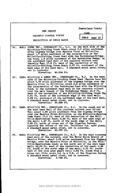
RV. 60SI: DOWSE TWP., CUMBERLAND CO., N°J. On the west side of the<br />
Millville-Divid<strong>in</strong> 8 Creek Road, about 5,0 miles southwest<br />
ofthe hl_hwa T bridge over Maurice River at Millville;<br />
about 1.7 miles southwest of the <strong>in</strong>tersection of the<br />
Millville-Dlvldlng Creek Road with the Buckshutem-Brldgeton<br />
Road; 1,8 miles southwest of the Euckahutem Swamp; <strong>in</strong><br />
the northwest head wall of the concrete culvert over<br />
Gravelly Run; 17.5 ft. west of the centerl<strong>in</strong>e of the<br />
Millville°Divld<strong>in</strong>g Creek Road; 0.SV ft. southeast of the<br />
west edge of the head wall. A standard monel metal rivet<br />
set <strong>in</strong> concrete.<br />
ElevLtlon: 46.S64 ft.<br />
8V. 6050: MILLVTLLE & DOWNE TWP., CUMBERLAND CO., N.J. On the west<br />
side of the Millville-Divid<strong>in</strong>g Creek Road (Rarrot Lane Rd)<br />
about S.75 miles southwest of the hi6hwa T bridge over the<br />
Maurice Etver <strong>in</strong> Millville; about 0.4 miles southwest of<br />
the <strong>in</strong>tersection of the Ruckshutem Road with the _lllvillq<br />
Road; In the northwest head wall of the concrete culvert<br />
over the ma<strong>in</strong> branoh of the Ruckshutem Swamp; 19,0 ft.<br />
west of the centerl<strong>in</strong>e of the Millville-Dividln 6 Creek Rd,<br />
0.81 ft. south of the northeast edge of the head wall;<br />
0.$9 ft. southeast of the northeest edge of the head wall.<br />
A standard monel metal rivet, set <strong>in</strong> concrete.<br />
Elevation: 35.525 ft.<br />
RV. 6029: MI[AVILLE TWp., CUmbERLAND CO., M.J. In the south end o£<br />
the west head wall of the coDcrete culvert over Silver<br />
Run; about 1.25 miles southwest from the hi_wa T bridge<br />
over the Maurice River_ Millville; on the Millville°Maurlee<br />
town Road; IV.O ft. west of the centerllne of the Millville-Mauricetown<br />
Road; O.gO ft. west of the east edge of<br />
the wall; 1.4T ft. north of the south edge of the wall;<br />
0._ ft. north of cross cut of the Riparian <strong>Survey</strong>;<br />
opposite the of£1ee of the Gee. Pettionoe Inc. sand plant.<br />
A standard monel metal rivet, set <strong>in</strong> concrete.<br />
Elevation: 10.707 f_.<br />
RV. 6028: MILLVILLE TWP., CUMBERLAND CO., N.J. In the vest concrete<br />
head wall of the culvert, over the White Marsh Branch of<br />
Maurlce River. about 0.SS miles southwest from the Ei_J_w_<br />
bridge, over the Maurics River at Millville, on the Millville-Mau_ieetown<br />
road; on the north end of the west head<br />
wall; 26.00 ft. west of the ¢enterl<strong>in</strong>e of the ro_d; 0.82<br />
ft. sout_ of the north edge of the wall; O.SI ft, southeast<br />
of the Iron pipe guard rail; 0.84 ft. south from a<br />
croea cut (thi_ o_osa cut is s 8.M. of the Riparian Sure<br />
A standard monel metal rivet, set <strong>in</strong> concrete.<br />
Elevation: _.7_5 ft.<br />
NEW JERSEY GEOLOGICAL SURVEY


