Navigation is Key to AUV Missions - Paroscientific, Inc.
Navigation is Key to AUV Missions - Paroscientific, Inc.
Navigation is Key to AUV Missions - Paroscientific, Inc.

You also want an ePaper? Increase the reach of your titles
YUMPU automatically turns print PDFs into web optimized ePapers that Google loves.
increased, and thus survey productivity<br />
- an <strong>AUV</strong> should be able <strong>to</strong><br />
operate at four knots compared with<br />
the present 1-2 knots of a survey<br />
vessel with deep<strong>to</strong>w f<strong>is</strong>h trailing<br />
behind.<br />
Various studies have been made <strong>to</strong><br />
calculate the savings that could be<br />
made by using <strong>AUV</strong>s for deepwater<br />
surveys rather than conventional<br />
methods. Shell, for example, calculated<br />
that over five years it could<br />
save $100 million in terms of direct<br />
operational costs and by reducing<br />
design conservat<strong>is</strong>m.<br />
Since then, others have looked at<br />
the Shell figures and extrapolated on<br />
them. Kongsberg Simrad <strong>is</strong> one of<br />
them: it says that overall savings on<br />
deepwater developments worldwide<br />
could amount <strong>to</strong> $772 million over<br />
five years!<br />
The Vehicles<br />
Given th<strong>is</strong> delightful prospect of<br />
better data combined with cost savings,<br />
it <strong>is</strong> not surpr<strong>is</strong>ing that <strong>AUV</strong>s are<br />
now making their appearance in the<br />
commercial survey market. Currently<br />
there are four main contenders:<br />
• C&C Technologies, Lafayette,<br />
Lou<strong>is</strong>iana, has conducted deepwater<br />
m<strong>is</strong>sions on BP’s Gulf of Mexico Mad<br />
Dog and Holstein fields using its<br />
Hugin <strong>AUV</strong>, designed and built by<br />
Kongsberg Simrad, Norway. It <strong>is</strong> rated<br />
<strong>to</strong> 3,000 meters, powered by a unique<br />
aluminium oxygen fuel cell for 40-<br />
hour endurance and has a Simrad<br />
EM2000 multibeam sounder,<br />
EdgeTech chirp sidescan and sub-bot<strong>to</strong>m<br />
profiler, Seabird CTD and a magne<strong>to</strong>meter.<br />
On extended m<strong>is</strong>sions, the<br />
performance of internal control systems<br />
(including navigation) was<br />
“exceptional,” reports BP.<br />
• Bluefin Robotics, USA <strong>is</strong> about <strong>to</strong><br />
deliver the first of two Oracle vehicles<br />
for Thales Survey, U.K., which will<br />
have a depth capability of 3,000<br />
meters.<br />
• Maridan A/S, Denmark, delivered<br />
the first M600 <strong>AUV</strong> <strong>to</strong> De Beers<br />
Marine, Cape Town <strong>to</strong> search for diamonds<br />
using a survey sensor payload<br />
which includes RESON 8125 imaging<br />
sonar, Klein 2000 digital sidescan,<br />
GeoAoustics Geochirp sub-bot<strong>to</strong>m<br />
profiler and SRD au<strong>to</strong>nomous v<strong>is</strong>ual<strong>is</strong>ation<br />
system. A further M600 <strong>is</strong> conducting<br />
surveys for BP in the Gulf of<br />
Mexico; another <strong>is</strong> working for<br />
BP/Shell in the mid-North Sea, operating<br />
with Gardline Surveys on a combine<br />
geophysical-geotechnical survey.<br />
• A potent teaming <strong>is</strong> that of Boeing<br />
Company, Fugro GeoServices <strong>Inc</strong> and<br />
Oceaneering International <strong>Inc</strong>. by the<br />
end of th<strong>is</strong> year they will have in the<br />
water a 5.7 meter long vehicle that<br />
weighs 5,300 kilograms in air, has a<br />
10-<strong>to</strong>n handling system, 3,000 meter<br />
depth rating and <strong>is</strong> fitted with sidescan<br />
sonar, sub-bot<strong>to</strong>m profiler, multibeam<br />
sounder and TV.<br />
Boeing brings its 30 years of experience<br />
in developing and operating vehicles<br />
for the government [it <strong>is</strong> currently<br />
the prime contrac<strong>to</strong>r for the U.S.<br />
Navy’s Long-term Mine Reconna<strong>is</strong>sance<br />
System (LMRS)]; Fugro will<br />
provide the sensor payload and data<br />
analys<strong>is</strong> technologies; Oceaneering<br />
will be responsible for surface ship<br />
handling and the vehicle launch and<br />
recovery system.<br />
<strong>Navigation</strong> Systems<br />
It’s fairly obvious that one of the key<br />
requirements for an <strong>AUV</strong> <strong>is</strong> its navigation<br />
system: if you are going <strong>to</strong> let<br />
your multi-million-dollar baby go<br />
roaming round the deep ocean unsuperv<strong>is</strong>ed<br />
for two days at a time you<br />
need <strong>to</strong> be sure that she will pop up <strong>to</strong><br />
greet you at a pre-arranged location,<br />
having gathered high quality data<br />
accurately referenced <strong>to</strong> her pre-programmed<br />
route.<br />
So, it’s in underwater navigation<br />
that some of the greatest innovations<br />
are <strong>to</strong> be found in the current <strong>AUV</strong><br />
front-runners.<br />
C&C’s Hugin <strong>is</strong> positioned by a<br />
Kalman filter-aided INS system which<br />
integrates inertial navigation with RD<br />
Instruments’ doppler velocity log,<br />
fiber optic gyro, depth sensor, altitude/forward-looking<br />
sensor and<br />
Kongsberg Simrad super short baseline<br />
(SSBL) HiPap positioning.<br />
Maridan reports that “underwater<br />
navigational technology <strong>is</strong> a primary<br />
focal point” for its engineering team.<br />
For its <strong>AUV</strong>s, Maridan developed the<br />
Marpos system in association with the<br />
Dan<strong>is</strong>h Technical University and<br />
Kearfott Guidance and <strong>Navigation</strong><br />
Corporation, USA.<br />
Marpos <strong>is</strong> an integrated dopplerinertial<br />
system at the core of which <strong>is</strong><br />
a high prec<strong>is</strong>ion ring-laser-gyro strapdown<br />
inertial navigation system<br />
(INS)—the KN5053—developed by<br />
Kearfott. The INS <strong>is</strong> mechanically<br />
aligned with RDI’s 1200 kilohertz<br />
DVL - which measures vehicle speed<br />
over the ground or through water -<br />
and, for surface navigation, a DGPS<br />
receiver. A Kalman filter resident in<br />
the INS performs real-time integration<br />
of the sensor measurements <strong>to</strong> provide<br />
accurate position, attitude and attitude<br />
rate information in all axes.<br />
Orientation (including heading) <strong>is</strong><br />
determined by Marpos in an alignment<br />
process where the Kalman filter uses<br />
the gyros and accelerometers <strong>to</strong> determine<br />
local gravity vec<strong>to</strong>r and the<br />
Earth’s rotation. Alignment <strong>is</strong> performed<br />
either statically or moving<br />
(using DGPS or RDI’s DVL) <strong>to</strong> an<br />
accuracy of around 0.03° rms.<br />
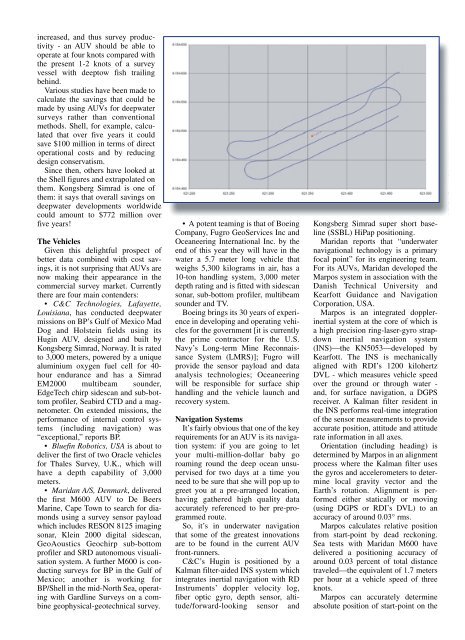
Marpos calculates relative position<br />
from start-point by dead reckoning.<br />
Sea tests with Maridan M600 have<br />
delivered a positioning accuracy of<br />
around 0.03 percent of <strong>to</strong>tal d<strong>is</strong>tance<br />
traveled—the equivalent of 1.7 meters<br />
per hour at a vehicle speed of three<br />
knots.<br />
Marpos can accurately determine<br />
absolute position of start-point on the