Navigation is Key to AUV Missions - Paroscientific, Inc.
Navigation is Key to AUV Missions - Paroscientific, Inc.
Navigation is Key to AUV Missions - Paroscientific, Inc.

You also want an ePaper? Increase the reach of your titles
YUMPU automatically turns print PDFs into web optimized ePapers that Google loves.
ST <strong>Navigation</strong> Feature<br />
<strong>Navigation</strong> <strong>is</strong> <strong>Key</strong> <strong>to</strong> <strong>AUV</strong><br />
M<strong>is</strong>sions<br />
Various Studies Have Been Made <strong>to</strong> Calculate the Savings That<br />
Could be Made by Using <strong>AUV</strong>s for Deepwater Surveys Rather<br />
Than Conventional Methods<br />
By John Romeo<br />
and<br />
Graham Lester<br />
RD Instruments <strong>Inc</strong>.<br />
San Diego, California<br />
As in so many other areas of subsea<br />
technology, the commercial<br />
development of au<strong>to</strong>nomous underwater<br />
vehicles (<strong>AUV</strong>s) has been driven<br />
by the demands of the offshore oil<br />
industry.<br />
As oil and gas exploration and production<br />
activities move in<strong>to</strong> the<br />
“Golden Triangle” deepwater (1,000<br />
<strong>to</strong> 3,000 meters) areas of the Gulf of<br />
Mexico, off Brazil and off West<br />
Africa, there <strong>is</strong> a requirement for high<br />
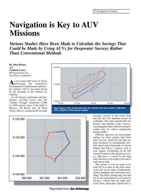
Each figure in th<strong>is</strong> article describes the outward and return paths of Maridan<br />
150 in relation <strong>to</strong> the various targets.<br />
accuracy surveys of the ocean floor<br />
and the first few hundred meters of<br />
sediments. The tasks include drill site<br />
hazard and pipeline route surveys,<br />
oceanographic data collection and providing<br />
data for subsea engineering<br />
design studies.<br />
Offshore opera<strong>to</strong>rs are increasingly<br />
calling for better quality data from<br />
these surveys. Until now the data has<br />
been produced by instrumented <strong>to</strong>wf<strong>is</strong>h<br />
<strong>to</strong>wed many thousands of meters<br />
behind and below a surface craft at<br />
slow speeds. Positioning of the f<strong>is</strong>h<br />
cannot be made <strong>to</strong> the required accuracy;<br />
ship time <strong>is</strong> wasted by the long<br />
turns that have <strong>to</strong> be made at the end of<br />
each survey line.<br />
The answer <strong>is</strong> seen by many <strong>to</strong> lie<br />
with <strong>AUV</strong>s <strong>to</strong> take on the basic deepwater<br />
site survey tasks of bathymetry,<br />
seabed mapping and sub-bot<strong>to</strong>m profiling.<br />
The time-wasting long turn and<br />
run-in on a grid pattern <strong>is</strong> overcome by<br />
having a vehicle that can make relatively<br />
short, sharp turns. Speed, <strong>to</strong>o, <strong>is</strong><br />
Reprinted from Sea Technology
increased, and thus survey productivity<br />
- an <strong>AUV</strong> should be able <strong>to</strong><br />
operate at four knots compared with<br />
the present 1-2 knots of a survey<br />
vessel with deep<strong>to</strong>w f<strong>is</strong>h trailing<br />
behind.<br />
Various studies have been made <strong>to</strong><br />
calculate the savings that could be<br />
made by using <strong>AUV</strong>s for deepwater<br />
surveys rather than conventional<br />
methods. Shell, for example, calculated<br />
that over five years it could<br />
save $100 million in terms of direct<br />
operational costs and by reducing<br />
design conservat<strong>is</strong>m.<br />
Since then, others have looked at<br />
the Shell figures and extrapolated on<br />
them. Kongsberg Simrad <strong>is</strong> one of<br />
them: it says that overall savings on<br />
deepwater developments worldwide<br />
could amount <strong>to</strong> $772 million over<br />
five years!<br />
The Vehicles<br />
Given th<strong>is</strong> delightful prospect of<br />
better data combined with cost savings,<br />
it <strong>is</strong> not surpr<strong>is</strong>ing that <strong>AUV</strong>s are<br />
now making their appearance in the<br />
commercial survey market. Currently<br />
there are four main contenders:<br />
• C&C Technologies, Lafayette,<br />
Lou<strong>is</strong>iana, has conducted deepwater<br />
m<strong>is</strong>sions on BP’s Gulf of Mexico Mad<br />
Dog and Holstein fields using its<br />
Hugin <strong>AUV</strong>, designed and built by<br />
Kongsberg Simrad, Norway. It <strong>is</strong> rated<br />
<strong>to</strong> 3,000 meters, powered by a unique<br />
aluminium oxygen fuel cell for 40-<br />
hour endurance and has a Simrad<br />
EM2000 multibeam sounder,<br />
EdgeTech chirp sidescan and sub-bot<strong>to</strong>m<br />
profiler, Seabird CTD and a magne<strong>to</strong>meter.<br />
On extended m<strong>is</strong>sions, the<br />
performance of internal control systems<br />
(including navigation) was<br />
“exceptional,” reports BP.<br />
• Bluefin Robotics, USA <strong>is</strong> about <strong>to</strong><br />
deliver the first of two Oracle vehicles<br />
for Thales Survey, U.K., which will<br />
have a depth capability of 3,000<br />
meters.<br />
• Maridan A/S, Denmark, delivered<br />
the first M600 <strong>AUV</strong> <strong>to</strong> De Beers<br />
Marine, Cape Town <strong>to</strong> search for diamonds<br />
using a survey sensor payload<br />
which includes RESON 8125 imaging<br />
sonar, Klein 2000 digital sidescan,<br />
GeoAoustics Geochirp sub-bot<strong>to</strong>m<br />
profiler and SRD au<strong>to</strong>nomous v<strong>is</strong>ual<strong>is</strong>ation<br />
system. A further M600 <strong>is</strong> conducting<br />
surveys for BP in the Gulf of<br />
Mexico; another <strong>is</strong> working for<br />
BP/Shell in the mid-North Sea, operating<br />
with Gardline Surveys on a combine<br />
geophysical-geotechnical survey.<br />
• A potent teaming <strong>is</strong> that of Boeing<br />
Company, Fugro GeoServices <strong>Inc</strong> and<br />
Oceaneering International <strong>Inc</strong>. by the<br />
end of th<strong>is</strong> year they will have in the<br />
water a 5.7 meter long vehicle that<br />
weighs 5,300 kilograms in air, has a<br />
10-<strong>to</strong>n handling system, 3,000 meter<br />
depth rating and <strong>is</strong> fitted with sidescan<br />
sonar, sub-bot<strong>to</strong>m profiler, multibeam<br />
sounder and TV.<br />
Boeing brings its 30 years of experience<br />
in developing and operating vehicles<br />
for the government [it <strong>is</strong> currently<br />
the prime contrac<strong>to</strong>r for the U.S.<br />
Navy’s Long-term Mine Reconna<strong>is</strong>sance<br />
System (LMRS)]; Fugro will<br />
provide the sensor payload and data<br />
analys<strong>is</strong> technologies; Oceaneering<br />
will be responsible for surface ship<br />
handling and the vehicle launch and<br />
recovery system.<br />
<strong>Navigation</strong> Systems<br />
It’s fairly obvious that one of the key<br />
requirements for an <strong>AUV</strong> <strong>is</strong> its navigation<br />
system: if you are going <strong>to</strong> let<br />
your multi-million-dollar baby go<br />
roaming round the deep ocean unsuperv<strong>is</strong>ed<br />
for two days at a time you<br />
need <strong>to</strong> be sure that she will pop up <strong>to</strong><br />
greet you at a pre-arranged location,<br />
having gathered high quality data<br />
accurately referenced <strong>to</strong> her pre-programmed<br />
route.<br />
So, it’s in underwater navigation<br />
that some of the greatest innovations<br />
are <strong>to</strong> be found in the current <strong>AUV</strong><br />
front-runners.<br />
C&C’s Hugin <strong>is</strong> positioned by a<br />
Kalman filter-aided INS system which<br />
integrates inertial navigation with RD<br />
Instruments’ doppler velocity log,<br />
fiber optic gyro, depth sensor, altitude/forward-looking<br />
sensor and<br />
Kongsberg Simrad super short baseline<br />
(SSBL) HiPap positioning.<br />
Maridan reports that “underwater<br />
navigational technology <strong>is</strong> a primary<br />
focal point” for its engineering team.<br />
For its <strong>AUV</strong>s, Maridan developed the<br />
Marpos system in association with the<br />
Dan<strong>is</strong>h Technical University and<br />
Kearfott Guidance and <strong>Navigation</strong><br />
Corporation, USA.<br />
Marpos <strong>is</strong> an integrated dopplerinertial<br />
system at the core of which <strong>is</strong><br />
a high prec<strong>is</strong>ion ring-laser-gyro strapdown<br />
inertial navigation system<br />
(INS)—the KN5053—developed by<br />
Kearfott. The INS <strong>is</strong> mechanically<br />
aligned with RDI’s 1200 kilohertz<br />
DVL - which measures vehicle speed<br />
over the ground or through water -<br />
and, for surface navigation, a DGPS<br />
receiver. A Kalman filter resident in<br />
the INS performs real-time integration<br />
of the sensor measurements <strong>to</strong> provide<br />
accurate position, attitude and attitude<br />
rate information in all axes.<br />
Orientation (including heading) <strong>is</strong><br />
determined by Marpos in an alignment<br />
process where the Kalman filter uses<br />
the gyros and accelerometers <strong>to</strong> determine<br />
local gravity vec<strong>to</strong>r and the<br />
Earth’s rotation. Alignment <strong>is</strong> performed<br />
either statically or moving<br />
(using DGPS or RDI’s DVL) <strong>to</strong> an<br />
accuracy of around 0.03° rms.<br />
Marpos calculates relative position<br />
from start-point by dead reckoning.<br />
Sea tests with Maridan M600 have<br />
delivered a positioning accuracy of<br />
around 0.03 percent of <strong>to</strong>tal d<strong>is</strong>tance<br />
traveled—the equivalent of 1.7 meters<br />
per hour at a vehicle speed of three<br />
knots.<br />
Marpos can accurately determine<br />
absolute position of start-point on the
seabed in water depths less than 200<br />
meters. At greater depths, the startpoint<br />
may need <strong>to</strong> be determined after<br />
transit <strong>to</strong> the seabed—perhaps by<br />
using USBL—because of accumulated<br />
drift during the dive.<br />
For deepsea applications Maridan<br />
has developed a new concept called<br />
synthetic long baseline (SLBL) which<br />
uses a single transponder instead of a<br />
full LBL spread. Since the <strong>AUV</strong> <strong>is</strong><br />
able <strong>to</strong> follow a straight line very accurately<br />
using Marpos, it can trigger the<br />
transponder from different locations<br />
and thus calculate its position after a<br />
few pings.<br />
Maridan demonstrated the accuracy<br />
of the Marpos dead reckoning system<br />
in a mine reconna<strong>is</strong>sance survey for<br />
the Royal Dan<strong>is</strong>h Navy in S<strong>to</strong>rebaelt,<br />
Denmark. The graph shows the path of<br />
the survey by the Maridan 150 vehicle<br />
with an enlarged section showing the<br />
targets. They were obtained by a<br />
Tritech International SeaKing 675<br />
kilohertz sidescan sonar.<br />
The Thales-Bluefin Oracle vehicle<br />
looks <strong>to</strong> achieve 0.1 percent accuracy<br />
of d<strong>is</strong>tance traveled (or about 30 cm at<br />
3,000 m depth). Thales’ Stewart<br />
Cannon describes the system:<br />
Oracle has a single board computer<br />
running software produced by the C. S<br />
Draper Labora<strong>to</strong>ry of MIT and interfaced<br />
<strong>to</strong> several sensors. The software<br />
mechan<strong>is</strong>es the “shadow naviga<strong>to</strong>r”<br />
concept by using data from the actual<br />
linear acceleration and angular motion<br />
of the <strong>AUV</strong> in an external inertial navigation<br />
algorithm (i.e. outside of the<br />
INS) and <strong>is</strong> combined with measurements<br />
from additional sensors in an<br />
extended Kalman filter <strong>to</strong> yield the<br />
overall best estimate of the navigation<br />
state.<br />
The main navigation sensor <strong>is</strong> the<br />
Lit<strong>to</strong>n LN-250 MIMU, a fiber optic<br />
gyro-based, navigation grade<br />
(1n.m./hr free inertial accuracy) system<br />
cons<strong>is</strong>ting of three interferometric<br />
fiber optic gyroscopes and three<br />
accelerometers mounted on an inertial<br />
block assembly.<br />
The other sensors include: a<br />
Digiquartz pressure sensor <strong>to</strong> measure<br />
ambient water pressure (which <strong>is</strong> converted<br />
in<strong>to</strong> depth); an ultra short baseline<br />
(USBL) positioning system<br />
between the ship and a vehicle-mounted<br />
transponder; and the RD<br />
Instruments 600 kilohertz DVL.<br />
At the pre-launch stage a moving<br />
baseline alignment of the LN-250 <strong>is</strong><br />
performed by acquiring position and<br />
velocity data from the shipboard navi-<br />
20 years<br />
of experience<br />
neatly packaged<br />
in<strong>to</strong> every unit<br />
we deliver.<br />
In 1982, RD Instruments developed the world’s first Acoustic<br />
Doppler Current Profiler (ADCP). Twenty years later we<br />
are still developing the most advanced technology in<br />
the field, with a reputation for unparalleled reliability<br />
and first class cus<strong>to</strong>mer service.<br />
From estuaries <strong>to</strong> oceans, RDI provides<br />
accurate doppler instruments for a<br />
wide array of marine motion<br />
applications. Allow us <strong>to</strong><br />
put our wealth of<br />
experience <strong>to</strong><br />
work for<br />
you.<br />
9855 Businesspark Avenue, San Diego, CA 92131-1101 USA<br />
Tel. 858-693-1178<br />
www.rdinstruments.com
“Position calibration of the <strong>AUV</strong> on the seafloor may be performed<br />
with a single seafloor transponder of use a vesselbased<br />
USBL.”<br />
replace.<br />
RD Instruments has installed its<br />
Workhorse DVLs on more than 90<br />
percent of the world <strong>AUV</strong> fleet and on<br />
over 100 ROVs. /st/<br />
gation system while the ship maneuvers<br />
in a slow circle for up <strong>to</strong> 20 minutes.<br />
When the <strong>AUV</strong> <strong>is</strong> descending, the<br />
INS <strong>is</strong> in barometer-aided mode and<br />
uses the Digiquartz <strong>to</strong> sense depth.<br />
The USBL system may also be used <strong>to</strong><br />
track the vehicle, with updates made<br />
by the shipboard navigation computer<br />
telemetered <strong>to</strong> the <strong>AUV</strong>. On arrival at<br />
the seafloor the RDI DVL bot<strong>to</strong>mlocks<br />
and begins providing velocity<br />
data <strong>to</strong> the <strong>AUV</strong> navigation system.<br />
Data acqu<strong>is</strong>ition now begins with<br />
time, position, velocity, heading and<br />
attitude data provided <strong>to</strong> the vehicle<br />
control computer for both guidance<br />
and control. When the vehicle ascends<br />
the same procedure as for descent <strong>is</strong><br />
followed and once on the surface the<br />
GPS system <strong>is</strong> used <strong>to</strong> bring ship and<br />
vehicle <strong>to</strong>gether.<br />
The Boeing/Fugro/Oceaneering<br />
vehicle’s navigation system <strong>is</strong> based<br />
on the full integration of all available<br />
sensors including INS, a hybrid RDI<br />
DVL, altimeter, depth, LBL and<br />
USBL. Inputs in<strong>to</strong> th<strong>is</strong> Kalman filter<br />
can include roll, pitch, heading, vehicle<br />
accelerations, vehicle velocity,<br />
height above seafloor, depth, ranges <strong>to</strong><br />
transponders on the seafloor or USBL<br />
data from a vessel at the surface.<br />
Position calibration of the <strong>AUV</strong> on the<br />
seafloor may be performed with a single<br />
seafloor transponder of use a vessel-based<br />
USBL.<br />
What all four of these main contenders<br />
in the commercial <strong>AUV</strong> business<br />
have in common <strong>is</strong> the RD<br />
Instruments doppler velocity log. Th<strong>is</strong><br />
measures velocity relative <strong>to</strong> the<br />
seafloor and altitude over the seafloor.<br />
It uses four beams at 30° from the vertical<br />
in convex configuration <strong>to</strong> insonify<br />
the seafloor and measures the<br />
doppler shift of the return. Th<strong>is</strong> shift <strong>is</strong><br />
then converted on<strong>to</strong> an accurate velocity<br />
vec<strong>to</strong>r.<br />
RDI systems for the Racal,<br />
Boeing/Fugro/Oceaneering and C&C<br />
<strong>AUV</strong>s are 600 kilohertz versions with<br />
a minimum range of 0.7 meter and<br />
maximum of 90 meters and with an<br />
accuracy of ±0.2 percent at 1 millimeter<br />
per sec - around 0.004m/sec at<br />
three knots. The Maridan RDI DVL <strong>is</strong><br />
a 1,200 kilohertz instrument. A further<br />
instrument in the standard RDI<br />
Workhorse Naviga<strong>to</strong>r DVL range<br />
operates at 300 kilohertz. Across the<br />
range, therefore, the DVLs operate<br />
between 0.5 meters and 200 meters<br />
above the seafloor with a depth rating<br />
of 2,000 meters standard, 6,000 meters<br />
optional.<br />
Cus<strong>to</strong>mized units are also produced<br />
—a recent example <strong>is</strong> for a number of<br />
specialized systems for Coastal<br />
Systems Station (CSS) in Panama<br />
City, Florida. These <strong>to</strong>ok the place of<br />
four competing systems that did not<br />
meet requirements on CSS <strong>AUV</strong>s,<br />
with the RDI DVL noted in the<br />
Commerce Business Daily bulletin as<br />
“the only unit proven <strong>to</strong> meet all operational<br />
requirements.” RDI reconfigured<br />
its smaller DVL <strong>to</strong> fit in the footprint<br />
of the competing model, <strong>to</strong> suit<br />
the retrofit requirements. RDI’s navigation<br />
device <strong>is</strong> not only smaller but<br />
also less expensive than the original<br />
equipment.<br />
The CSS experience with RDI’s<br />
DVLs led it <strong>to</strong> recommend them <strong>to</strong><br />
Boeing Company, which was experiencing<br />
similar problems with a navigation<br />
system on its Long-term Mine<br />
Reconna<strong>is</strong>sance System (LMRS)<br />
under development by Boeing for the<br />
U.S. Navy. Th<strong>is</strong> <strong>is</strong> an unmanned surveillance<br />
system that provides a clandestine<br />
capability <strong>to</strong> determine the<br />
ex<strong>is</strong>tence of mines in potential threat<br />
environments.<br />
Boeing was having problems with<br />
the ex<strong>is</strong>ting navigation units on the<br />
LMRS—they easily lost bot<strong>to</strong>m track<br />
and were slow <strong>to</strong> reacquire it. The U.S.<br />
Navy’s Coastal Systems Station,<br />
Florida, (CSS) had also had problems<br />
with the same units on its own underwater<br />
vehicles and had replaced them<br />
with RDI. These performed well and<br />
CSS recommended Boeing <strong>to</strong> make<br />
the same replacement on the LMRS.<br />
The RDI cus<strong>to</strong>mized DVLs use<br />
broadband bot<strong>to</strong>m track technology <strong>to</strong><br />
give a unit that <strong>is</strong> smaller, more accurate<br />
(0.2 percent of depth) and which<br />
reacquire bot<strong>to</strong>m track far more quickly<br />
than the narrow band units they<br />
John Romeo has worked on the development<br />
of a wide range of RD Instruments<br />
products for the past 14 years. He has a<br />
formal background in manufacturing engineering<br />
along with international business<br />
and marketing. He <strong>is</strong> navigation business<br />
unit manager for RD Instruments.<br />
Graham Lester <strong>is</strong> RD Instruments’ technical<br />
sales manager for the <strong>Navigation</strong><br />
Business Unit. He applies h<strong>is</strong> market<br />
development knowledge <strong>to</strong> underwater<br />
navigation based on h<strong>is</strong> background in<br />
avionics and h<strong>is</strong> experience in marine survey<br />
systems.