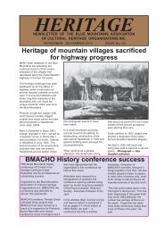
Newsletter No - Blue Mountains Association of Cultural Heritage ...
Newsletter No - Blue Mountains Association of Cultural Heritage ...
Newsletter No - Blue Mountains Association of Cultural Heritage ...

Create successful ePaper yourself
Turn your PDF publications into a flip-book with our unique Google optimized e-Paper software.
These were not<br />
in the <strong>Blue</strong><br />
<strong>Mountains</strong><br />
Continued from page 19<br />
geology, and because the accounts<br />
are some <strong>of</strong> the earliest <strong>of</strong> any<br />
value, it is relevant to consider the<br />
matters raised. Gammage states<br />
that on his first expedition Wilson<br />
reached the Wingecarribee-<br />
Wollondilly junction northwest<br />
<strong>of</strong> Berrima. In what is now<br />
mostly dense forest, they<br />
crossed “fine open country, but<br />
very mountainous”, grass<br />
meadows, thinly timbered<br />
plains. And scrub and vine<br />
brushes, including Bargo<br />
Brush, soon notorious for poor<br />
soil, stringybark, and tangles<br />
<strong>of</strong> scrub and fallen timber.<br />
This interpretation relies on<br />
Cambage (1920) and Chisholm<br />
(1955).<br />
Subsequent analyses by Andrews<br />
(1990) and Brownscombe (2004),<br />
and also by the writer<br />
(unpublished), discount that view.<br />
The terminus <strong>of</strong> the first expedition<br />
was almost certainly in the Berrima-<br />
Bong Bong area, which now<br />
features open farming country.<br />
The particular “fine open country,<br />
but very mountainous” country<br />
mentioned in the above quote was<br />
actually encountered on January<br />
27, 1798 when the party appears to<br />
have been travelling up the long<br />
ramp which forms the watershed<br />
between the Bargo River and the<br />
Nepean system.<br />
The surface geology for much <strong>of</strong> the<br />
way consists <strong>of</strong> Wianamatta Shales<br />
and would, if burnt frequently, have<br />
produced open grassy forest (as at<br />
Springwood).<br />
Much <strong>of</strong> the area, such as around<br />
Yerrinbool, is now occupied by<br />
small farms, not scrub.<br />
Gammage further states (still page<br />
197):<br />
In March 1798 Wilson led<br />
another party to Mt Towrang<br />
east <strong>of</strong> Goulburn… He found<br />
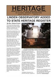
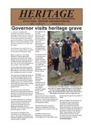
Figure 4: Rural scene near Berrima. This is the country crossed by<br />
John Wilson on March 19, 1798, which Gammage states is “thick <strong>of</strong><br />
timber” today. A. Macqueen 2011<br />
“a most beautiful country,<br />
being nothing but fine large<br />
meadows with pools <strong>of</strong> water<br />
in them; fine green hills, but<br />
very thin <strong>of</strong> timber.” They are<br />
thick <strong>of</strong> timber now.<br />
The “most beautiful country, being<br />
nothing but fine large meadows …”<br />
was nowhere near the party’s Mount<br />
Towrang terminus.<br />
It was reported by the diarist on<br />
March 19, 1798 just south <strong>of</strong><br />
Berrima, in today’s aforementioned<br />
open farmlands. It is certainly not<br />
“thick <strong>of</strong> timber” today. (Figure 4)<br />
To conclude. The archaeological<br />
record tells us that the sandstone<br />
terrain <strong>of</strong> the <strong>Blue</strong> <strong>Mountains</strong> was <strong>of</strong><br />
great cultural significance to the<br />
traditional owners.<br />
However, the pattern, frequency<br />
and purpose <strong>of</strong> their occupation or<br />
visits is not well understood.<br />
(Attenbrow 2009)<br />
<strong>No</strong>r is the nature <strong>of</strong> their burning<br />
practices.<br />
However, it can be said with<br />
reasonable certainty, based on the<br />
early historical accounts and on the<br />
botanical evidence, that most <strong>of</strong> the<br />
sandstone country was covered in<br />
the scrubby vegetation that we still<br />
see today, rather than the open<br />
grassy woodlands that many<br />
imagine. (Macqueen 2004, ch4;<br />
Benson & Redpath 1997)<br />
This is not inconsistent with<br />
Gammage’s thesis. He<br />
acknowledges that “people burnt<br />
the most useful land most and the<br />
most sterile or sensitive land<br />
perhaps not for generations”, and<br />
that they might only have burnt dry<br />
ridges “every 15-25 years”.<br />
(Gammage, pp162, 165)<br />
However, if dry ridge country <strong>of</strong> the<br />
<strong>Blue</strong> <strong>Mountains</strong> were left alone for<br />
such periods one would expect that<br />
fire from lightning ignitions,<br />
accidental ignitions, or escaped<br />
fires, would attain more<br />
significance.<br />
This would be consistent with<br />
palaeoenvironmental research<br />
which suggests that the frequency<br />
and intensity <strong>of</strong> fire on the <strong>Blue</strong><br />
<strong>Mountains</strong> mainly reflected the<br />
climate. (Mooney & Martin 2009)<br />
Setting those questions aside, it is<br />
unfortunate that Gammage’s above<br />
acknowledgement is relatively<br />
hidden in the book.<br />
By the manner in which he presents<br />
examples from the <strong>Blue</strong> <strong>Mountains</strong><br />
historical record, he implicitly invites<br />
the reader to think that attention<br />
would have been given to all the<br />
mountains on a detailed and<br />
frequent basis.<br />
However, from the above discussion<br />
one is entitled to conclude that the<br />
pieces <strong>of</strong> evidence cited have not<br />
been properly examined with<br />
respect to their context or<br />
relevance.<br />
Continued page 21<br />
HERITAGE 20<br />
July - August 2013