lungau summer in the hills brochure - Blasiwirt
lungau summer in the hills brochure - Blasiwirt
lungau summer in the hills brochure - Blasiwirt

Create successful ePaper yourself
Turn your PDF publications into a flip-book with our unique Google optimized e-Paper software.
Theme & Nature Trails Hik<strong>in</strong>g Trails & Hik<strong>in</strong>g Tours<br />
Flavor of <strong>the</strong> High Country Fabulous Hikes to Alp<strong>in</strong>e Tarns<br />
General Information<br />
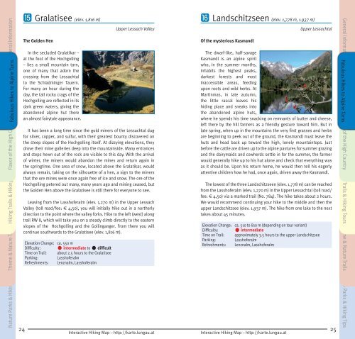
Gralatisee (elev. 1,816 m)<br />
The Golden Hen<br />
In <strong>the</strong> secluded Gralatikar –<br />
at <strong>the</strong> foot of <strong>the</strong> Hochgoll<strong>in</strong>g<br />
– lies a small mounta<strong>in</strong> tarn,<br />
one of many that adorn <strong>the</strong><br />
cross<strong>in</strong>g from <strong>the</strong> Lessachtal<br />
to <strong>the</strong> Schladm<strong>in</strong>ger Tauern.<br />
For many an hour dur<strong>in</strong>g <strong>the</strong><br />
day, <strong>the</strong> tall rocky crags of <strong>the</strong><br />
Hochgoll<strong>in</strong>g are reflected <strong>in</strong> its<br />
dark green waters, giv<strong>in</strong>g <strong>the</strong><br />
abandoned alp<strong>in</strong>e hut <strong>the</strong>re<br />
an almost fairytale appearance.<br />
Upper Lessach Valley<br />
It has been a long time s<strong>in</strong>ce <strong>the</strong> gold m<strong>in</strong>ers of <strong>the</strong> Lessachtal dug<br />
for silver, copper, and sulfur, with <strong>the</strong>ir greatest bounty discovered on<br />
<strong>the</strong> steep slopes of <strong>the</strong> Hochgoll<strong>in</strong>g itself. At dizzy<strong>in</strong>g elevations, <strong>the</strong>y<br />
drove <strong>the</strong>ir m<strong>in</strong>e galleries deep <strong>in</strong>to <strong>the</strong> mounta<strong>in</strong>side. Many entrances<br />
and steps hewn out of <strong>the</strong> rock are visible to this day. With <strong>the</strong> arrival<br />
of w<strong>in</strong>ter, <strong>the</strong> m<strong>in</strong>ers would abandon <strong>the</strong> m<strong>in</strong>es and return aga<strong>in</strong> <strong>in</strong><br />
<strong>the</strong> spr<strong>in</strong>gtime. One area of snow, located above <strong>the</strong> Gralatikar, would<br />
always rema<strong>in</strong>, tak<strong>in</strong>g on <strong>the</strong> silhouette of a hen, a sign to <strong>the</strong> m<strong>in</strong>ers<br />
that <strong>the</strong> ore m<strong>in</strong>es were once aga<strong>in</strong> free of ice and snow. The ore of <strong>the</strong><br />
Hochgoll<strong>in</strong>g petered out many, many years ago and m<strong>in</strong><strong>in</strong>g ceased, but<br />
<strong>the</strong> Golden Hen above <strong>the</strong> Gralatisee is still <strong>the</strong>re for everyone to see.<br />
Leav<strong>in</strong>g from <strong>the</strong> Lasshoferalm (elev. 1,270 m) <strong>in</strong> <strong>the</strong> Upper Lessach<br />
Valley (toll road/fee: € 4,50), you will <strong>in</strong>itially hike out <strong>in</strong> a nor<strong>the</strong>rly<br />
direction to <strong>the</strong> po<strong>in</strong>t where <strong>the</strong> valley forks. Hike to <strong>the</strong> left (west) along<br />
trail RW 8, which will take you on a steady climb directly to <strong>the</strong> eastern<br />
slopes of <strong>the</strong> Hochgoll<strong>in</strong>g and <strong>the</strong> Goll<strong>in</strong>ganger. From <strong>the</strong>re you will<br />
cont<strong>in</strong>ue southwards to <strong>the</strong> Gralatisee (elev. 1,816 m).<br />
• <strong>in</strong>termediate to • difficult<br />
Elevation Change: ca. 550 m<br />
Difficulty:<br />
Time on Trail: about 2.5 hours to <strong>the</strong> Gralatisee<br />
Park<strong>in</strong>g:<br />
Lasshoferalm<br />
Refreshments: Lenznalm, Lasshoferalm<br />
Landschitzseen (elev. 1,778 m, 1.937 m)<br />
Of <strong>the</strong> mysterious Kasmandl<br />
Upper Lessachtal<br />
The dwarf-like, half-savage<br />
Kasmandl is an alp<strong>in</strong>e spirit<br />
who, <strong>in</strong> <strong>the</strong> <strong>summer</strong> months,<br />
<strong>in</strong>habits <strong>the</strong> highest peaks,<br />
darkest forests and most<br />
<strong>in</strong>accessible areas, feed<strong>in</strong>g<br />
upon roots and wild herbs. At<br />
Mart<strong>in</strong>mas, <strong>in</strong> late autumn,<br />
<strong>the</strong> little rascal leaves his<br />
hid<strong>in</strong>g place and sneaks <strong>in</strong>to<br />
<strong>the</strong> abandoned alp<strong>in</strong>e huts,<br />
where he spends his time snack<strong>in</strong>g on remnants of butter and cheese,<br />
left <strong>the</strong>re by <strong>the</strong> hill farmers as a friendly gesture toward him. But <strong>in</strong><br />
late spr<strong>in</strong>g, when up <strong>in</strong> <strong>the</strong> mounta<strong>in</strong>s <strong>the</strong> very first grasses and herbs<br />
are beg<strong>in</strong>n<strong>in</strong>g to peek out of <strong>the</strong> ground, <strong>the</strong> Kasmandl must leave <strong>the</strong><br />
huts and head back up toward <strong>the</strong> high, lonely mounta<strong>in</strong>tops. Just<br />
before <strong>the</strong> cattle are driven up to <strong>the</strong> alp<strong>in</strong>e pastures for <strong>summer</strong> graz<strong>in</strong>g<br />
and <strong>the</strong> dairymaids and cowherds settle <strong>in</strong> for <strong>the</strong> <strong>summer</strong>, <strong>the</strong> farmer<br />
would generally hike up to his hut alone and check that everyth<strong>in</strong>g was<br />
as it should be. Upon his return home, he would <strong>the</strong>n tell his eagerly<br />
attentive children how he had, once aga<strong>in</strong>, driven away <strong>the</strong> Kasmandl.<br />
The lowest of <strong>the</strong> three Landschitzseen (elev. 1,778 m) can be reached<br />
from <strong>the</strong> Lasshoferalm (elev. 1,270 m) <strong>in</strong> <strong>the</strong> Upper Lessachtal (toll road/<br />
fee: € 4,50) via a marked trail (No. 784). The hike takes about 2 hours.<br />
We would recommend cont<strong>in</strong>u<strong>in</strong>g your hike to <strong>the</strong> middle and <strong>the</strong>n <strong>the</strong><br />
upper Landschitzsee (elev. 1,937 m). The hike from one lake to <strong>the</strong> next<br />
takes about 45 m<strong>in</strong>utes.<br />
Elevation Change: ca. 510 to 810 m (depend<strong>in</strong>g on tour variant)<br />
Difficulty:<br />
• <strong>in</strong>termediate<br />
Time on Trail: approximately 3.5 hours to <strong>the</strong> upper Landschitzsee<br />
Park<strong>in</strong>g:<br />
Lasshoferalm<br />
Refreshments: Lenznalm, Lasshoferalm<br />
General Information Fabulous Hikes to Alp<strong>in</strong>e Tarns<br />
Flavor of <strong>the</strong> High Country Hik<strong>in</strong>g Trails & Hik<strong>in</strong>g Tours Theme & Nature Trails<br />
Nature Parks & Hik<strong>in</strong>g Tips<br />
24 25<br />
Interactive Hik<strong>in</strong>g Map – http://karte.<strong>lungau</strong>.at<br />
Interactive Hik<strong>in</strong>g Map – http://karte.<strong>lungau</strong>.at<br />
Nature Parks & Hik<strong>in</strong>g Tips