download - Wavelength Paddling Magazine
download - Wavelength Paddling Magazine
download - Wavelength Paddling Magazine
You also want an ePaper? Increase the reach of your titles
YUMPU automatically turns print PDFs into web optimized ePapers that Google loves.
passenger ferry service and trails make<br />
Newcastle Island accessible even without<br />
a kayak.<br />
Newcastle Island may be the focus for<br />
trips in the harbour, but it’s not the only<br />
place to paddle. Jesse Island, a private<br />
island in Departure Bay, has bold sandstone<br />
cliffs to explore with the bonus of<br />
the only paddle-through sea cave in the<br />
Gulf Islands and great scuba diving. The<br />
main residents are two dogs that watch<br />
over the property, loudly proclaiming<br />
their dominance to anyone who passes<br />
by. Caught unawares, their barks could<br />
send you out of your sprayskirt. It’s hard<br />
to tell if they’re as vicious as they sound,<br />
but it’s probably best left untested. It’s a<br />
shame—the owners have no foreshore<br />
rights, so anyone should have beach access,<br />
but the dogs make that impossible.<br />
If you continue north along the shoreline<br />
past Departure Bay, you round more<br />
headlands and more beaches, like Piper’s<br />
Lagoon with its long gravel beach and<br />
rocky headland protected as a city park,<br />
and Neck Point, a more recent park addition<br />
in Nanaimo. The waters around<br />
both headlands are favourite places for<br />
sea lions to feed. Usually a head or two<br />
will surface at some point during a trip<br />
past here.<br />
Between the two parks is Shack Island,<br />
named for the humble cottages that dot<br />
the island. They sit much as they have<br />
for decades, their presence on the Crown<br />
land due to squatters’ rights, something<br />
that precludes any improvements. If seeing<br />
this picturesque island doesn’t make<br />
you want to pick up a paintbrush and<br />
paint, nothing will.<br />
If you head east out of Departure Bay<br />
(towards the mainland) you’ll reach a<br />
small cluster of rocky islands. These are<br />
all part of Hudson Rock Ecological Reserve,<br />
created to protect a population of<br />
pelagic cormorants that, sadly, has spiraled<br />
in decline. In 1987, 142 nests were<br />
counted; in 2000, just three were found.<br />
It’s a fate shared across the Gulf Islands<br />
and Strait of Georgia. Is it due to human<br />
encroachment? Possibly. Is it from the<br />
resurgence in the number of predatory<br />
bald eagles? Probably. You can pass by<br />
and look for evidence yourself, but you<br />
can’t stop to investigate because access<br />
is by permit only. The other residents of<br />
the islands—mostly nesting murres and<br />
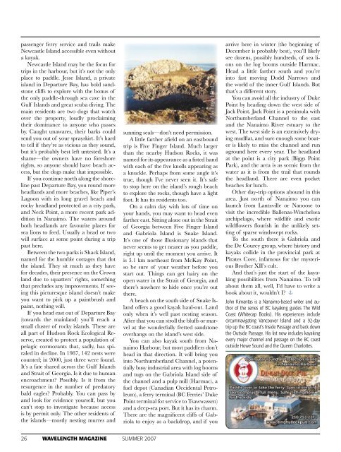
Five Finger Island<br />
sunning seals—don’t need permission.<br />
A little farther afield on an eastbound<br />
trip is Five Finger Island. Much larger<br />
than the nearby Hudson Rocks, it was<br />
named for its appearance as a fisted hand<br />
with each of the five knolls appearing as<br />
a knuckle. Perhaps from some angle it’s<br />
true, though I’ve never seen it. It’s safe<br />
to stop here on the island’s rough beach<br />
to explore the rocks, though have a light<br />
foot. It has its residents too.<br />
On a calm day with lots of time on<br />
your hands, you may want to head even<br />
farther east. Sitting alone out in the Strait<br />
of Georgia between Five Finger Island<br />
and Gabriola Island is Snake Island.<br />
It’s one of those illusionary islands that<br />
never seems to get nearer as you paddle,<br />
right up until the moment you arrive. It<br />
is 3.1 km northeast from McKay Point,<br />
so be sure of your weather before you<br />
start out. Things can get hairy on the<br />
open water in the Strait of Georgia, and<br />
there’s nowhere to hide once you’re out<br />
there.<br />
A beach on the south side of Snake Island<br />
offers a good kayak haul-out. Land<br />
only when it’s well past nesting season.<br />
After that you can stroll the bluffs or marvel<br />
at the wonderfully fretted sandstone<br />
overhangs on the island’s west side.<br />
You can also kayak south from Nanaimo<br />
Harbour, but most paddlers don’t<br />
head in that direction. It will bring you<br />
into Northumberland Channel, a potentially<br />
busy industrial area with log booms<br />
and tugs on the Gabriola Island side of<br />
the channel and a pulp mill (Harmac), a<br />
fuel depot (Canadian Occidental Petroleum),<br />
a ferry terminal (BC Ferries’ Duke<br />
Point terminal for service to Tsawwassen)<br />
and a deep-sea port. But it has its charm.<br />
There are the magnificent cliffs of Gabriola<br />
to enjoy as a backdrop, and if you<br />
arrive here in winter (the beginning of<br />
December is probably best), you’ll likely<br />
see dozens, possibly hundreds, of sea lions<br />
on the log booms outside Harmac.<br />
Head a little farther south and you’re<br />
into fast moving Dodd Narrows and<br />
the world of the inner Gulf Islands. But<br />
that’s a different story.<br />
You can avoid all the industry of Duke<br />
Point by heading down the west side of<br />
Jack Point. Jack Point is a peninsula with<br />
Northumberland Channel to the east<br />
and the Nanaimo River estuary to the<br />
west. The west side is an extensively drying<br />
mudflat, and sure enough some boater<br />
is likely to miss the channel and run<br />
aground here every year. The headland<br />
at the point is a city park (Biggs Point<br />
Park), and the area is as scenic from the<br />
water as it is from the trail that rounds<br />
the headland. There are even pocket<br />
beaches for lunch.<br />
Other day-trip options abound in this<br />
area. Just north of Nanaimo you can<br />
launch from Lantzville or Nanoose to<br />
visit the incredible Ballenas-Winchelsea<br />
archipelago, where wildlife and exotic<br />
wildflowers flourish in the unlikely setting<br />
of sparse windswept rocks.<br />
To the south there is Gabriola and<br />
the De Courcy group, where history and<br />
kayaks collide in the provincial park at<br />
Pirates Cove, infamous for the mysterious<br />
Brother XII’s cult.<br />
And that’s just the start of the kayaking<br />
possibilities from Nanaimo. To tell<br />
about them all, well, I’d have to write a<br />
book about it, wouldn’t I? <br />
John Kimantas is a Nanaimo-based writer and author<br />
of the series of BC kayaking guides The Wild<br />
Coast (Whitecap Books). His experiences include<br />
circumnavigating Vancouver Island and a 92-day<br />
trip up the BC coast’s Inside Passage and back down<br />
the Outside Passage. His list now includes kayaking<br />
every major channel and passage on the BC coast<br />
outside Howe Sound and the Queen Charlottes.<br />
26 WAVELENGTH MAGAZINE SUMMER 2007


