Download Full Catalogue - swalim
Download Full Catalogue - swalim
Download Full Catalogue - swalim

You also want an ePaper? Increase the reach of your titles
YUMPU automatically turns print PDFs into web optimized ePapers that Google loves.
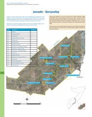
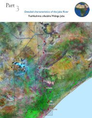
1.2 Water Resources DatasetsSWALIM has developed a number of water resources datasets including climate, riverflow, water sources and irrigation. These are briefly described below:• Climate data set contains data from 68 stations rehabilitated by SWALIM andpartners and five automatic weather stations. Most of the data is on rainfall,but a few stations have other parameters, such as temperature, wind speed andevaporation. The data recorded spans over 100 years. Due to the civil war, somegaps exist, mainly between 1991 and 2002. A summary of these data is presentedin the inventory report entitled: “Inventory of Hydrometeorological Data forSomalia - Project Report no W-03 - October 2007”, (see Section 1.1), and a list ofthe rainfall recording stations is provided in Annex I.• River flow data contains daily and monthly river flows and stream gauge heightsover a 30-year period for 15 river gauging stations that were previously operatedby the Somali Government (seven on the Juba river and eight on the Shabelleriver). The data is currently stored in HYDATA database and MS Excel sheets.There is a gap from 1991 to 2002 due to the civil war during this period. Asummary of this data is presented in the inventory report entitled: “Inventoryof Hydrometeorological Data for Somalia - Project Report no W-03 - October2007”, (see Section 1.1). A list of the river gauging stations is provided in AnnexII.• Water sources data has been generated through partners working in the watersector in Somalia and through surveys carried out by SWALIM in Somaliland,Puntland and south central Somalia. 2 250 records of strategic water sources(boreholes, shallow wells, springs and dams) were added to the Somalia WaterSources Information Management System (SWIMS). The survey data and resultsare compiled in a DVD accessible from SWALIM. The the survey results arereported in two reports titled, “Water Sources Survey for Northern Somalia,Project Report no W-12” and “Water Sources Survey for Central and SouthSomalia, Project Report no W-13” (see Section 1.1). A summary of the watersources database is provided in Annex III.• Irrigation infrastructure data set contains records of Southern Somalia’s prewarirrigation infrastructure including barrages, primary and secondary canals,schemes/projects and partner agencies rehabilitated infrastructure. These arestored in GIS format. The data provides information on the status of the irrigationschemes and their infrastructure. The database was generated using GeographicInformation System (GIS) analysis of 1:100,000 topographic maps and recentsatellite images. The database has been verified through rapid field assessmentand workshops in Baidoa and Nairobi. A summary of this data is provided inAnnex IV. SWALIM has also used data from an aerial survey which covers most ofthe irrigation schemes (See section 6.0)11