Download Full Catalogue - swalim
Download Full Catalogue - swalim
Download Full Catalogue - swalim

Create successful ePaper yourself
Turn your PDF publications into a flip-book with our unique Google optimized e-Paper software.
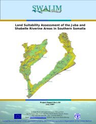
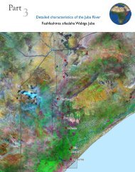
Field Survey ManualThe field survey manual was developed to guide SWALIM landresources baseline data collection activities. It provides a theoreticaland practical basis for collecting land resources data in the field.The manual contains five sections covering landform mapping, soilsurvey, land degradation assessment, land use survey and land covermapping. Each section is followed by a set of field data collectionforms or questionnaires. Although the manual was developed for usein Somalia, it is applicable for other areas with similar bio-physicalenvironment.Land Use Characterisation of the Juba and Shabelle Riverine Areas inSouthern SomaliaLand use types in the Juba and Shabelle riverline areas wereidentified through land cover analysis, interviews with land usersand the use of past and current satellite images. The report alsoshows the characterisation of different land use present in the Jubaand Shabelle riverine areas. Land-use classes in the study area weredetermined through land cover analysis, semi-structured interviewsand interpretation of satellite imagery, and are described with theirspecific attributes. Users will obtain a detailed overview of land useactivities in the study area.Land Suitability Assessment of a Selected Study Area in SomalilandAs an input to guiding policy decisions on land use planning, thisstudy defines the capacity of the study area to support specificland use types. The main land use types considered were rainfedagriculture, extensive grazing (pastoralism) and forestry. Landsuitability is presented in the form of tables, maps and narrativesfor specific types of land use defined by individual crops, grazinganimals or forestry species. This report also gives details of theSomalia Automated Land Evaluation System (SOMALES), whichis an application of the FAO Framework for Land Evaluation andAutomated Land Evaluation Software (ALES) for Somalia.Land Suitability Assessment of the Juba and Shabelle Riverine Areas inSouthern SomaliaThis report describes physical land suitability for rainfed agriculture,irrigated agriculture, extensive grazing (pastoralism) and forestry inthe Juba and Shabelle riverine areas. Land suitability is presented inthe form of tables, maps and narratives for specific types of land usedefined by individual crops, grazing animals or forestry species. Thisreport also gives details of the Somalia Automated Land EvaluationSystem (SOMALES), which is an application of the FAO Frameworkfor Land Evaluation and ALES software for Somalia. The report isuseful in guiding policy decisions on land use planning.18