


You also want an ePaper? Increase the reach of your titles
YUMPU automatically turns print PDFs into web optimized ePapers that Google loves.
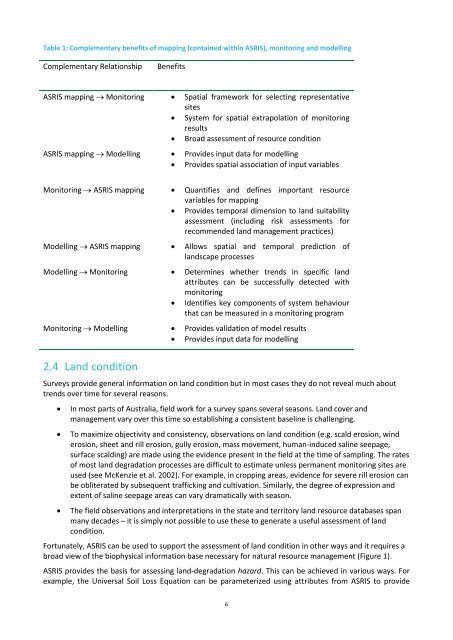
Table 1: Complementary benefits of mapping (contained within <strong>ASRIS</strong>), monitoring and modellingComplementary RelationshipBenefits<strong>ASRIS</strong> mapping → Monitoring • Spatial framework for selecting representativesites• System for spatial extrapolation of monitoringresults• Broad assessment of resource condition<strong>ASRIS</strong> mapping → Modelling • Provides input data for modelling• Provides spatial association of input variablesMonitoring → <strong>ASRIS</strong> mapping • Quantifies and defines important resourcevariables for mapping• Provides temporal dimension to land suitabilityassessment (including risk assessments forrecommended land management practices)Modelling → <strong>ASRIS</strong> mapping • Allows spatial and temporal prediction oflandscape processesModelling → Monitoring • Determines whether trends in specific landattributes can be successfully detected withmonitoring• Identifies key components of system behaviourthat can be measured in a monitoring programMonitoring → Modelling • Provides validation of model results• Provides input data for modelling2.4 Land conditionSurveys provide general information on land condition but in most cases they do not reveal much abouttrends over time for several reasons.• In most parts of Australia, field work for a survey spans several seasons. Land cover andmanagement vary over this time so establishing a consistent baseline is challenging.• To maximize objectivity and consistency, observations on land condition (e.g. scald erosion, winderosion, sheet and rill erosion, gully erosion, mass movement, human-induced saline seepage,surface scalding) are made using the evidence present in the field at the time of sampling. The ratesof most land degradation processes are difficult to estimate unless permanent monitoring sites areused (see McKenzie et al. 2002). For example, in cropping areas, evidence for severe rill erosion canbe obliterated by subsequent trafficking and cultivation. Similarly, the degree of expression andextent of saline seepage areas can vary dramatically with season.• The field observations and interpretations in the state and territory land resource databases spanmany decades – it is simply not possible to use these to generate a useful assessment of landcondition.Fortunately, <strong>ASRIS</strong> can be used to support the assessment of land condition in other ways and it requires abroad view of the biophysical information base necessary for natural resource management (Figure 1).<strong>ASRIS</strong> provides the basis for assessing land-degradation hazard. This can be achieved in various ways. Forexample, the Universal Soil Loss Equation can be parameterized using attributes from <strong>ASRIS</strong> to provide6


