


Create successful ePaper yourself
Turn your PDF publications into a flip-book with our unique Google optimized e-Paper software.
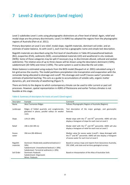
7 Level-2 descriptors (land region)Level 2 subdivides Level-1 units using physiographic distinctions at a finer level of detail. Again, relief andmodal slope are the primary discriminants. Level 2 in <strong>ASRIS</strong> has adopted the regions from the physiographicregions of Australia (Pain et al. 2011).Primary descriptors at Level 2 are relief, modal slope, regolith materials, dominant soil order, and anestimate of water-balance. As with Level 1, each tract has a geographic name and simple text description.Regolith materials are described using the first level of classification in Table 49 (unweathered bedrock(BU), evaporites (EVA), sediments (SDE), unconsolidated materials (UO) and weathered in-situ residuals(WIR)). Some of these categories may be split if necessary (e.g. to discriminate alluvial, colluvial and aeoliansediments). The relative area of up to three classes will be shown using the descriptors dominant (>50%),subdominant (20–50%) and minor (50%)Subdominant: Unweathered bedrock (< 20%)Subdomiant: Terrestrial sediments (< 20%)Dominant: RudosolsSubdominant: OrganosolsMinor: PodosolsBased on various maps and reports from Geoscience Australia,CRC LEME, and state and territory geological surveysBased on interpretation of the Atlas of Australian Soils22


