


Create successful ePaper yourself
Turn your PDF publications into a flip-book with our unique Google optimized e-Paper software.
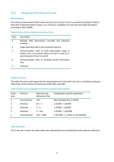
10.2 Mapping intensity and scaleObservationsThe nature of observations within each land-unit tract at Level 5 and 6 is recorded according to Table 8.Note that a field observation involves, as a minimum, completion of a full site and profile descriptionaccording to NCST (2009).Table 8: Nature of observations for the land-unit tractClassDescription1 Multiple field observations recorded and extensivetraverses2 Single field observation and restricted traverses3 Characterization relies on field observations made insimilar units in the parent District (if tract is Level 5) orparent System (if tract is Level 6)4 Characterization relies on remotely sensed informationonly5 UnknownOrder of surveyThe order of survey used to generate the interpretations for each land-unit tract is recorded according toTable 9 (for further details see Soil Survey Staff (1993, p48–49)).Table 9: Orders of survey (modified from Soil Survey Staff (1993, p48–49))OrderlevelIntensityMinimum sizedelineation (ha)Cartographic scale for publication1 Very intensive


