


You also want an ePaper? Increase the reach of your titles
YUMPU automatically turns print PDFs into web optimized ePapers that Google loves.
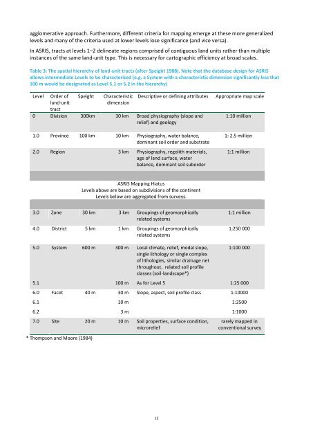
agglomerative approach. Furthermore, different criteria for mapping emerge at these more generalizedlevels and many of the criteria used at lower levels lose significance (and vice versa).In <strong>ASRIS</strong>, tracts at levels 1–2 delineate regions comprised of contiguous land units rather than multipleinstances of the same land-unit type. This is necessary for cartographic efficiency at broad scales.Table 3: The spatial hierarchy of land-unit tracts (after Speight 1988). Note that the database design for <strong>ASRIS</strong>allows intermediate Levels to be characterized (e.g. a System with a characteristic dimension significantly less that100 m would be designated as Level 5.1 or 5.2 in the hierarchy)LevelOrder ofland-unittractSpeightCharacteristicdimensionDescriptive or defining attributes0 Division 300km 30 km Broad physiography (slope andrelief) and geology1.0 Province 100 km 10 km Physiography, water balance,dominant soil order and substrate2.0 Region 3 km Physiography, regolith materials,age of land surface, waterbalance, dominant soil suborderAppropriate map scale1:10 million1: 2.5 million1:1 million<strong>ASRIS</strong> Mapping HiatusLevels above are based on subdivisions of the continentLevels below are aggregated from surveys.3.0 Zone 30 km 3 km Groupings of geomorphicallyrelated systems4.0 District 5 km 1 km Groupings of geomorphicallyrelated systems1:1 million1:250 0005.0 System 600 m 300 m Local climate, relief, modal slope,single lithology or single complexof lithologies, similar drainage netthroughout, related soil profileclasses (soil-landscape*)1:100 0005.1 100 m As for Level 5 1:25 0006.0 Facet 40 m 30 m Slope, aspect, soil profile class 1:100006.1 10 m 1:25006.2 3 m 1:10007.0 Site 20 m 10 m Soil properties, surface condition,microrelief* Thompson and Moore (1984)rarely mapped inconventional survey12


