Series Dual Grade Lasers
Series Dual Grade Lasers
Series Dual Grade Lasers

Create successful ePaper yourself
Turn your PDF publications into a flip-book with our unique Google optimized e-Paper software.
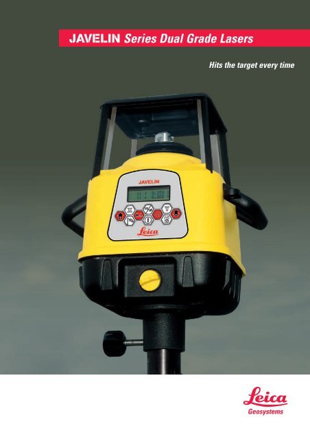
<strong>Series</strong> <strong>Dual</strong> <strong>Grade</strong> <strong>Lasers</strong>Hits the target every time
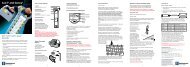
Javelin-s Remote Control CapabilityRod-Eye Pro Sensor providesfour levels of accuracy anda loud audio speaker.The Javelin-s laser system features an optional two-wayradio frequency controlled remote control device,designed to work up to 800 feet (245 m)* from the lasertransmitter. Two-way communication means that the userhas complete control of the laser. <strong>Grade</strong> changes arecompleted and communicated back to the user in justseconds. The remote control shuts off after 5 minutes ofinactivity to conserve battery power.* Under optimal conditionsSpecificationsWorking RangeSelf-leveling Accuracy3,000 feet (900 m) diameter± 6 arc seconds*Self-leveling Range ± 3°<strong>Grade</strong> CapabilityJavelinUp to ± 20% in both axesJavelin-sUp to ± 50% in both axes**Head Speeds300 to 1200 RpmBattery TypeNiMHBattery LifeUp to 30 hours withNiMH battery pack †Laser Diode635 nm visibleLaser ClassClass II FDA / Class 2 IECDimensions (Height x Width x Depth)Javelin12.3 x 12 x 10.6 inches(312 x 305 x 269 mm)Javelin-s14.4 x 12 x 10.6 inches(366 x 305 x 269 mm)Operating TemperatureWeightEnvironmental-4° F to +122°F (-20°C to +50°C)18.1 Ibs (8.2 kg) with batteriesWaterproof to IPX-7 standardRemote Control SpecificationsDistanceFrequency500 feet (150 m) typical;Up to 800 feet (245 m)2.402–2.478 GHzBattery Life 12 hours of continuous use †Battery TypeSizeWeight4 AA-Alkaline batteries4.25 x 2.25 x 7.62 inches(108 x 57 x 194 mm)25 oz (0.72 kg)* 23°F to +95°F (-5°C to +35°C). Accuracy is derated outside this range** Maximum total grade using both axes up to 55%† Battery life is dependant upon environmental conditionsLand Leveling, AgricultureSteep Slopes, Landfills... Hits the target every time
Leica GeosystemsIntegrated Solutions for the Construction Industry that are Rugged, Reliableand offer Exceptional Customer ValueThe Leica Geosystems Construction Business Segment has been strategically built to focus on the needs of the customer.Leica Geosystems is a pioneer of the survey world. Our history goes back 80 years and is marked by numerousdevelopments that have shaped the course taken by surveying, photogrammetry and GPS. Renowned names such asKern Aarau, Wild Heerbrugg and more recently Laser Alignment are among the companies that have become part ofwhat is today Leica Geosystems. Combined, these companies have played a major role in shaping the vision of ourorganization, deepening our knowledge of customer needs and providing market-leading product technologies andsolutions. Leica Geosystems' distribution companies and representatives provide you with support in 128 countries.Leica Geosystems – Global resources serving each customer individually.The Leica Geosystems Construction Segment Family of ProductsConstruction lasers – Whether it’s generalconstruction, pipe laying, machine control,or interior walls and ceilings, our lasersare built to handle any environment.Automatic levels – Professional opticallevels are built for the construction site.They are quickly set up, very precise, andtop every comparison of price toperformance ratios.Leader in GPS and TPS technology – Usedworldwide in projects that demand thehighest standards, designed for variousapplications and ease-of-use. Wedeveloped the first reflectorless totalstations in 1998, and our experience withGPS dates back to 1967.Conventional and 3D Machine ControlSystems – Boost productivity, increaseaccuracy, and reduce operator fatigue byconverting heavy equipment to laser,sonic, GPS and TPS guided control. Wehave applications for excavating, mining,grading, agriculture, and precision paving.Your Dealer:DIGI TM System – The location systemprovides a fast and safe solution fortracing buried utility services.Leica Geosystems GR LLCis an ISO 9001Registered Company.Software and accessories – Integratedsoftware solutions and a complete seriesof tripods, staffs, our patented 360°prisms, batteries, chargers, andeverything you need to extract the bestperformance from your instrument.Illustrations, descriptions and technical data are not binding and may be changed.Printed in Switzerland. Copyright Leica Geosystems GR LLC, Grand Rapids, Michigan, 2002.730754en – XI.03 – RDVLaser class 2 in accordancewith IEC 60825-1 and EN 60825-1Laser class II in accordancewith FDA 21CFR CH.1 § 1040Leica Geosystems GR LLC6330 28th Street SEGrand Rapids, MI 49546 USAPhone 616-949-7430www.leica-geosystems.comconstruction.leica-geosystems.com