Leica Viva TPS - Datasheet (430,50 KB) - Geosystems Africa
Leica Viva TPS - Datasheet (430,50 KB) - Geosystems Africa
Leica Viva TPS - Datasheet (430,50 KB) - Geosystems Africa

Create successful ePaper yourself
Turn your PDF publications into a flip-book with our unique Google optimized e-Paper software.
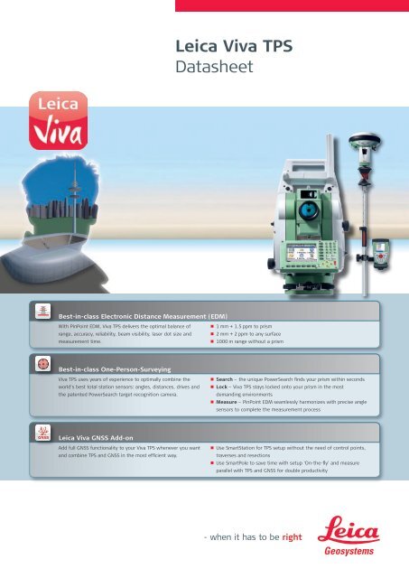
<strong>Leica</strong> <strong>Viva</strong> <strong>TPS</strong><strong>Datasheet</strong>Best-in-class Electronic Distance Measurement (EDM)With PinPoint EDM, <strong>Viva</strong> <strong>TPS</strong> delivers the optimal balance ofrange, accuracy, reliability, beam visibility, laser dot size andmeasurement time.•n 1 mm + 1.5 ppm to prism•n 2 mm + 2 ppm to any surface•n 1000 m range without a prismBest-in-class One-Person-Surveying<strong>Viva</strong> <strong>TPS</strong> uses years of experience to optimally combine theworld’s best total station sensors: angles, distances, drives andthe patented PowerSearch target recognition camera.• n Search – the unique PowerSearch finds your prism within seconds• n Lock – <strong>Viva</strong> <strong>TPS</strong> stays locked onto your prism in the mostdemanding environments• n Measure – PinPoint EDM seamlessly harmonizes with precise anglesensors to complete the measurement process<strong>Leica</strong> <strong>Viva</strong> GNSS Add-onAdd full GNSS functionality to your <strong>Viva</strong> <strong>TPS</strong> whenever you wantand combine <strong>TPS</strong> and GNSS in the most efficient way.•n Use SmartStation for <strong>TPS</strong> setup without the need of control points,traverses and resections•n Use SmartPole to save time with setup ‘On-the-fly’ and measureparallel with <strong>TPS</strong> and GNSS for double productivity
Technical Specifications <strong>TPS</strong>1200+<strong>Leica</strong> <strong>Viva</strong> <strong>TPS</strong> TC TCR TCRM TCA TCP TCRA TCRPAngle measurement • • • • • • •Distance measurement (Prism) • • • • • • •Distance measurement (Non-Prism) • • • •Motorized • • • • •Automatic Target Recognition (ATR) • • • •PowerSearch (PS) • •Guide Light (EGL) ¢ ¢ ¢ • • • •Remote Control Unit / RadioHandle ¢ ¢ ¢ ¢ ¢ ¢ ¢GUS74 Laser Guide ¢ ¢SmartStation (GS15, GS09) ¢ ¢ ¢ ¢ ¢ ¢ ¢• = Standard¢ = OptionalAngular Measurement Accuracy Hz, V 1 1’’ (0.3 mgon), 2’’ (0.6 mgon), 3’’ (1 mgon), 5’’ (1.5 mgon)Display resolution0.1’’ (0.1 mgon)MethodCompensationabsolute, continuous, diametricalQuadruple axis compensationCompensator setting accuracy0.5’’ (0.2 mgon), 0.5’’ (0.2 mgon), 1.0’’ (0.3 mgon), 1.5’’ (0.5 mgon)Distance MeasurementDistance Measurement (Prism)Range 2Round prism (GPR1)3<strong>50</strong>0 m (12000 ft)3 Round prisms (GPR1) 5400 m (17700 ft)360° prism (GRZ4, GRZ122) 2000 m (7000 ft)360° mini prism (GRZ101) 1000 m (3300 ft)Mini prism (GMP101)2000 m (7000 ft)Reflective tape (60 mm x 60 mm)2<strong>50</strong> m (800 ft)Accuracy 3,4 / Measurement TimeStandard1 mm + 1.5 ppmFast3 mm + 1.5 ppmTracking3 mm + 1.5 ppmAveraging1 mm + 1.5 ppmTypical Measurement Time <strong>50</strong>.8 sDistance Measurement (Non-Prism)Range 6PinPoint R400400 m (1310 ft)PinPoint R10001000 m (3280 ft)Accuracy 3,7 / Measurement TimePinPoint R400 / R10002 mm + 2 ppm / typ. 3 sDistance Measurement (Long-range)Long-range 2,4>10000 m (>32800 ft)Accuracy 3,6 / Measurement TimeLong-range5 mm + 2 ppm / typ. 2.5 sGeneralDisplay resolution0.1 mmShortest measurable distance1.5 mMethodSystem analyzer based on phase shift measurement (coaxial, visible red laser)Laser dot size (Non-Prism)At 30 m: 7 mm x 10 mm, at <strong>50</strong> m: 8 mm x 20 mmGeneralTelescopeMagnification30 xFree objective aperture40 mmField of view1° 30’ (1.66 gon) / 2.7 m at 100 mFocusing range1.7 m to infinityKeyboard and DisplayDisplay1/4 VGA (320*240 pixels), graphic LCD, color, illumination, touch screenKeyboard34 keys (12 function keys, 12 alphanumeric keys), illuminationPositionface I standard / face II optionalData storageInternal memory / Memory card256 MB (optional) / CompactFlash cards (256 MB)Number of data records17<strong>50</strong> / MBInterfaceRS232, Bluetooth ® Wireless-Technology (optional)OperationSensitivity of Circular level6’ / 2 mmCentering accuracy of Laser plummet1.5 mm at 1.5 mNumber of drives1 horizontal / 1 verticalPower ManagementInternal BatteryLithium IonOperating Time5 – 8 h (GEB221)Voltage / Capacity7.4 V / 4.4 AhWeight and DimensionsWeight of Total Station / Battery GEB221 / Tribrach GEB121 4.8 – 5.5 kg / 0.2 kg / 0.8 kgHeight / Width / Length345 mm / 226 mm / 203 mmEnvironmental specificationsWorking / Storage temperature range-20° C to +<strong>50</strong>° C / -40° C to +70° CDust / water (IEC 60529) / HumidityIP54 / 95%, non-condensingGuide Light (EGL) Working Range 5 – 1<strong>50</strong> mPositioning accuracy5 cm at 100 m
<strong>Leica</strong> <strong>Viva</strong> One-Person-SurveyingMotorization Rotation speed 45° (<strong>50</strong> gon) / sAutomatic Target Recognition (ATR) Range ATR Mode Lock ModeRound prism (GPR1) 1000 m (3300 ft) 800 m (2600 ft)Power Search (PS)360° prism (GRZ4, GRZ122) 800 m (2600 ft) 600 m (2000 ft)360° mini prism (GRZ101) 3<strong>50</strong> m (11<strong>50</strong> ft) 300 m (1000 ft)Mini prism (GMP101) <strong>50</strong>0 m (1600 ft) 400 m (1300 ft)Reflective tape (60 mm x 60 mm) 55 m (175 ft) -Shortest distance to 360° prism 1.5 m 5 mAccuracy 1 / Measurement TimeATR angle accuracy Hz, VBase positioning accuracyMeasurement Time for GPR11“ (0.3 mgon)±1 mm3 – 4 sMaximum speed (Lock Mode)Tangential (standard mode)5 m / s at 20 m, 25 m / s at 100 mRadial (tracking mode)4 m / sSearchingSearch time in field of viewTyp. 1.5 sField of view1° 30’ (1.66 gon)Definable search windowsYesMethodDigital Image processingRangeRound prism (GPR1)300 m (1000 ft)360° reflector 8 (GRZ4, GRZ122) 300 m (1000 ft)Mini prism (GMP101)100 m (330 ft)Shortest distance1.5 mSearchingTypical search time5 – 10 sDefault search areaHz: 360° (400 gon), V: 36° (40 gon)Definable search windowsYesMethodDigital Image processing (rotating laser fan)<strong>Leica</strong> <strong>Viva</strong> SmartStationGNSS Add-on Position accuracy 9,10 Horizontal: 10 mm + 1 ppm, Vertical: 20 mm + 1 ppmRTK InitializationReliability / Time of initialization>99.99% / Typically 8 s, with 5 or more satellites on L1 and L2RangeUp to <strong>50</strong> km, assuming reliable data-link is availableRTK Data formats for data reception<strong>Leica</strong> proprietary formats (<strong>Leica</strong>, <strong>Leica</strong> Lite, <strong>Leica</strong> 4G), GPS and GNSSreal-time data formats, CMR, CMR+, RTCM v2.1 / 2.3 / 3.0 / 3.1GNSS AntennaNumber of channels GS15: 120GS09: 120Dimensions (diameter x height)GS15: 196 mm x 198 mmGS09: 186 mm x 89 mmWeight (w/o battery)GS15: 1.34 kgGS09: 0.96 kg1Standard deviation ISO 17123-32Overcast, no haze, visibility about 40 km; no heat shimmer3Standard deviation ISO 17123-44To Round Prism GPR15Fast Mode6Object in shade, sky overcast, Kodak Grey Card (90% reflective)7Distance ><strong>50</strong>0 m 4 mm + 2 ppm8Target perfectly aligned to the instrument9Measurement precision and accuracy in position and accuracy in height are dependent upon various factors including number ofsatellites, geometry, observation time, ephemeris accuracy, ionospheric conditions, multipath etc. Figures quoted assume normalto favorable conditions. Times can also not be quoted exactly. Times required are dependent upon various factors includingnumber of satellites, geometry, ionospheric conditions, multipath etc. The following accuracies, given as root mean square,are based on real-time measurements.10When used within reference station networks the position accuracy is in accordance with the accuracy specifications provided bythe reference station network.
Whether you want to stake-out an object on a construction site or youneed accurate measurements of a tunnel or a bridge; whether youwant to determine the area of a parcel of land or need the position ofa power pole or to capture objects for as-built maps – you needreliable and precise data.<strong>Leica</strong> <strong>Viva</strong> combines a wide range of innovative products designed tomeet the daily challenges for all positioning tasks. The simple yetpowerful and versatile <strong>Leica</strong> <strong>Viva</strong> hardware and software innovationsare redefining state-of-the-art technology to deliver maximum performanceand productivity. <strong>Leica</strong> <strong>Viva</strong> gives you the inspiration to makeyour ambitious visions come true.When it has to be right.Illustrations, descriptions and technical data are not binding. All rights reserved.Printed in Switzerland – Copyright <strong>Leica</strong> <strong>Geosystems</strong> AG, Heerbrugg, Switzerland, 2009.774197en – IX.09 – RDVTotal Quality Management –our commitment to totalcustomer satisfaction.Distance meter (Prism),ATR and PowerSearch:Laser class 1 in accordancewith IEC 60825-1 resp. EN60825-1Laser plummet:Laser class 2 in accordancewith IEC 60825-1 resp. EN60825-1<strong>Leica</strong> <strong>Viva</strong>Overview brochure<strong>Leica</strong> <strong>Viva</strong> GNSSProduct brochure<strong>Leica</strong> SmartWorx<strong>Viva</strong>Product brochure<strong>Leica</strong> <strong>Viva</strong> LGOProduct brochure<strong>Leica</strong> ZenoProduct brochureDistance meter (Non-Prism):Laser class 3R in accordancewith IEC 60825-1 resp. EN60825-1The Bluetooth ® word mark andlogos are owned by BluetoothSIG, Inc. and any use of suchmarks by <strong>Leica</strong> <strong>Geosystems</strong> AG isunder license. Other trademarksand trade names are those oftheir respective owners.<strong>Leica</strong> <strong>Geosystems</strong> AGHeerbrugg, Switzerlandwww.leica-geosystems.com