

land subsidence and earth fissures in arizona - The Arizona ...
land subsidence and earth fissures in arizona - The Arizona ...
land subsidence and earth fissures in arizona - The Arizona ...

You also want an ePaper? Increase the reach of your titles
YUMPU automatically turns print PDFs into web optimized ePapers that Google loves.
LAND SUBSIDENCE & EARTH FISSURES IN ARIZONA<br />
recommend setback distances from <strong>earth</strong> <strong>fissures</strong>, or even if setbacks are an effective<br />
mitigation or prevention strategy, rema<strong>in</strong>s uncerta<strong>in</strong>. As a result, public officials charged with<br />
ensur<strong>in</strong>g public safety are unable to meet that charge even as growth cont<strong>in</strong>ues to encroach on<br />
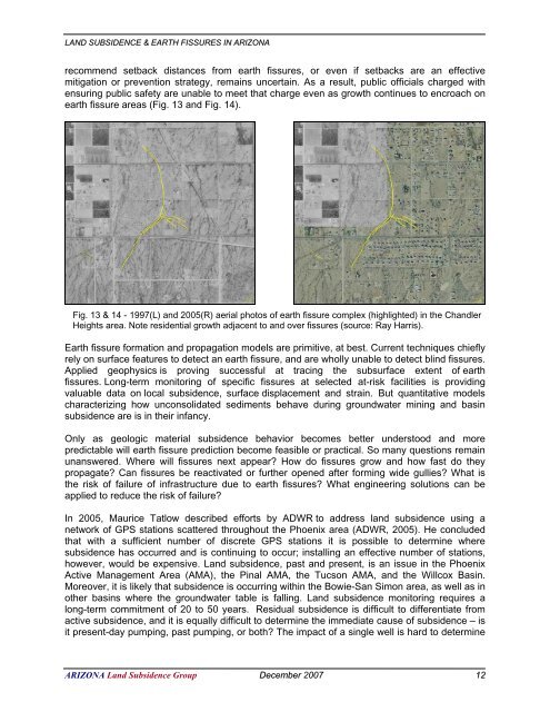
<strong>earth</strong> fissure areas (Fig. 13 <strong>and</strong> Fig. 14).<br />
Fig. 13 & 14 - 1997(L) <strong>and</strong> 2005(R) aerial photos of <strong>earth</strong> fissure complex (highlighted) <strong>in</strong> the Ch<strong>and</strong>ler<br />
Heights area. Note residential growth adjacent to <strong>and</strong> over <strong>fissures</strong> (source: Ray Harris).<br />
Earth fissure formation <strong>and</strong> propagation models are primitive, at best. Current techniques chiefly<br />
rely on surface features to detect an <strong>earth</strong> fissure, <strong>and</strong> are wholly unable to detect bl<strong>in</strong>d <strong>fissures</strong>.<br />
Applied geophysics is prov<strong>in</strong>g successful at trac<strong>in</strong>g the subsurface extent of <strong>earth</strong><br />
<strong>fissures</strong>. Long-term monitor<strong>in</strong>g of specific <strong>fissures</strong> at selected at-risk facilities is provid<strong>in</strong>g<br />
valuable data on local <strong>subsidence</strong>, surface displacement <strong>and</strong> stra<strong>in</strong>. But quantitative models<br />
characteriz<strong>in</strong>g how unconsolidated sediments behave dur<strong>in</strong>g groundwater m<strong>in</strong><strong>in</strong>g <strong>and</strong> bas<strong>in</strong><br />
<strong>subsidence</strong> are is <strong>in</strong> their <strong>in</strong>fancy.<br />
Only as geologic material <strong>subsidence</strong> behavior becomes better understood <strong>and</strong> more<br />
predictable will <strong>earth</strong> fissure prediction become feasible or practical. So many questions rema<strong>in</strong><br />
unanswered. Where will <strong>fissures</strong> next appear? How do <strong>fissures</strong> grow <strong>and</strong> how fast do they<br />
propagate? Can <strong>fissures</strong> be reactivated or further opened after form<strong>in</strong>g wide gullies? What is<br />
the risk of failure of <strong>in</strong>frastructure due to <strong>earth</strong> <strong>fissures</strong>? What eng<strong>in</strong>eer<strong>in</strong>g solutions can be<br />
applied to reduce the risk of failure?<br />
In 2005, Maurice Tatlow described efforts by ADWR to address <strong>l<strong>and</strong></strong> <strong>subsidence</strong> us<strong>in</strong>g a<br />
network of GPS stations scattered throughout the Phoenix area (ADWR, 2005). He concluded<br />
that with a sufficient number of discrete GPS stations it is possible to determ<strong>in</strong>e where<br />
<strong>subsidence</strong> has occurred <strong>and</strong> is cont<strong>in</strong>u<strong>in</strong>g to occur; <strong>in</strong>stall<strong>in</strong>g an effective number of stations,<br />
however, would be expensive. L<strong>and</strong> <strong>subsidence</strong>, past <strong>and</strong> present, is an issue <strong>in</strong> the Phoenix<br />
Active Management Area (AMA), the P<strong>in</strong>al AMA, the Tucson AMA, <strong>and</strong> the Willcox Bas<strong>in</strong>.<br />
Moreover, it is likely that <strong>subsidence</strong> is occurr<strong>in</strong>g with<strong>in</strong> the Bowie-San Simon area, as well as <strong>in</strong><br />
other bas<strong>in</strong>s where the groundwater table is fall<strong>in</strong>g. L<strong>and</strong> <strong>subsidence</strong> monitor<strong>in</strong>g requires a<br />
long-term commitment of 20 to 50 years. Residual <strong>subsidence</strong> is difficult to differentiate from<br />
active <strong>subsidence</strong>, <strong>and</strong> it is equally difficult to determ<strong>in</strong>e the immediate cause of <strong>subsidence</strong> – is<br />
it present-day pump<strong>in</strong>g, past pump<strong>in</strong>g, or both? <strong>The</strong> impact of a s<strong>in</strong>gle well is hard to determ<strong>in</strong>e<br />
ARIZONA L<strong>and</strong> Subsidence Group December 2007 12


