

land subsidence and earth fissures in arizona - The Arizona ...
land subsidence and earth fissures in arizona - The Arizona ...
land subsidence and earth fissures in arizona - The Arizona ...

You also want an ePaper? Increase the reach of your titles
YUMPU automatically turns print PDFs into web optimized ePapers that Google loves.
LAND SUBSIDENCE & EARTH FISSURES IN ARIZONA<br />
Fissure Gullies<br />
Because they commonly parallel nearby mounta<strong>in</strong> fronts, <strong>earth</strong> <strong>fissures</strong> cut across surface<br />
dra<strong>in</strong>age features. Surface runoff or flow <strong>in</strong>tercepted by an <strong>earth</strong> fissure has a vertical or nearvertical<br />
pathway to the subsurface groundwater table. <strong>The</strong> high gradient contributes to erosive<br />
forces that move sediments downward <strong>in</strong>to the fissure. As near-surface sediments are transported<br />
downward, erosion <strong>and</strong> cav<strong>in</strong>g at the surface creates a gully feature. <strong>The</strong> volume of water,<br />
erodability of sediments, size of the fissure rupture, <strong>and</strong> other geohydrologic parameters yield a<br />
unique result for each fissure. Result<strong>in</strong>g gullies can vary from slightly eroded <strong>fissures</strong> to gullies that<br />
are tens of feet wide <strong>and</strong> tens of feet deep (Fig. 4 <strong>and</strong> Fig. 5).<br />
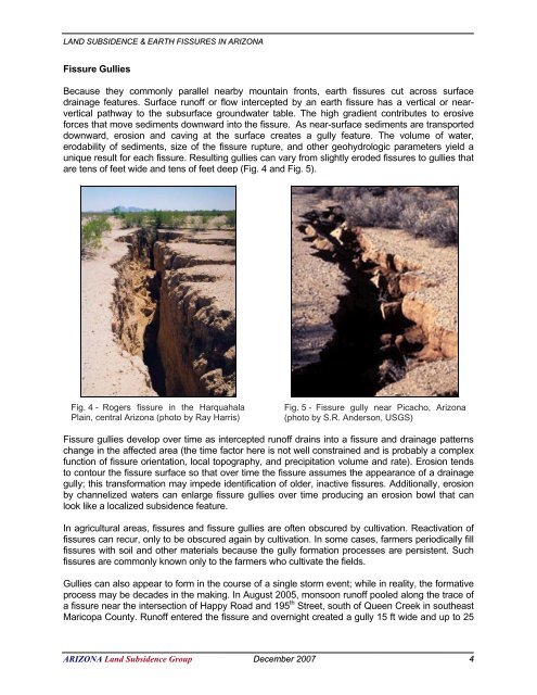
Fig. 4 - Rogers fissure <strong>in</strong> the Harquahala<br />
Pla<strong>in</strong>, central <strong>Arizona</strong> (photo by Ray Harris)<br />
Fig. 5 - Fissure gully near Picacho, <strong>Arizona</strong><br />
(photo by S.R. Anderson, USGS)<br />
Fissure gullies develop over time as <strong>in</strong>tercepted runoff dra<strong>in</strong>s <strong>in</strong>to a fissure <strong>and</strong> dra<strong>in</strong>age patterns<br />
change <strong>in</strong> the affected area (the time factor here is not well constra<strong>in</strong>ed <strong>and</strong> is probably a complex<br />
function of fissure orientation, local topography, <strong>and</strong> precipitation volume <strong>and</strong> rate). Erosion tends<br />
to contour the fissure surface so that over time the fissure assumes the appearance of a dra<strong>in</strong>age<br />
gully; this transformation may impede identification of older, <strong>in</strong>active <strong>fissures</strong>. Additionally, erosion<br />
by channelized waters can enlarge fissure gullies over time produc<strong>in</strong>g an erosion bowl that can<br />
look like a localized <strong>subsidence</strong> feature.<br />
In agricultural areas, <strong>fissures</strong> <strong>and</strong> fissure gullies are often obscured by cultivation. Reactivation of<br />
<strong>fissures</strong> can recur, only to be obscured aga<strong>in</strong> by cultivation. In some cases, farmers periodically fill<br />
<strong>fissures</strong> with soil <strong>and</strong> other materials because the gully formation processes are persistent. Such<br />
<strong>fissures</strong> are commonly known only to the farmers who cultivate the fields.<br />
Gullies can also appear to form <strong>in</strong> the course of a s<strong>in</strong>gle storm event; while <strong>in</strong> reality, the formative<br />
process may be decades <strong>in</strong> the mak<strong>in</strong>g. In August 2005, monsoon runoff pooled along the trace of<br />
a fissure near the <strong>in</strong>tersection of Happy Road <strong>and</strong> 195 th Street, south of Queen Creek <strong>in</strong> southeast<br />
Maricopa County. Runoff entered the fissure <strong>and</strong> overnight created a gully 15 ft wide <strong>and</strong> up to 25<br />
ARIZONA L<strong>and</strong> Subsidence Group December 2007 4


