

land subsidence and earth fissures in arizona - The Arizona ...
land subsidence and earth fissures in arizona - The Arizona ...
land subsidence and earth fissures in arizona - The Arizona ...

Create successful ePaper yourself
Turn your PDF publications into a flip-book with our unique Google optimized e-Paper software.
LAND SUBSIDENCE & EARTH FISSURES IN ARIZONA<br />
monitor<strong>in</strong>g of <strong>l<strong>and</strong></strong> <strong>subsidence</strong> <strong>and</strong> improve water resource management. ADWR has<br />
established Inter-Governmental Agreements with both the Flood Control District of Maricopa<br />
County <strong>and</strong> the P<strong>in</strong>al County Flood Control District to ensure fund<strong>in</strong>g is <strong>in</strong> place to monitor<br />
<strong>subsidence</strong> around each District's flood control structures. ADWR’s InSAR program is<br />
expensive. As a result, ADWR is pursu<strong>in</strong>g additional fund<strong>in</strong>g from other state <strong>and</strong> federal<br />
agencies to bolster their limited budget <strong>and</strong> cont<strong>in</strong>ue this important monitor<strong>in</strong>g program.<br />
Satellite imagery is prov<strong>in</strong>g useful for track<strong>in</strong>g <strong>subsidence</strong> <strong>and</strong> aid<strong>in</strong>g <strong>in</strong> del<strong>in</strong>eat<strong>in</strong>g zones at risk<br />
of <strong>earth</strong> fissur<strong>in</strong>g. Unfortunately, the state of the science is such that we can but broadly <strong>in</strong>fer<br />
where new <strong>fissures</strong> might form. <strong>The</strong> <strong>earth</strong> fissure zone <strong>in</strong> east Scottsdale at the CAP Canal near<br />
Cactus Road was discovered <strong>in</strong> part by us<strong>in</strong>g InSAR imagery. In several cases, analytical <strong>and</strong><br />
numerical models comb<strong>in</strong>ed with InSAR data were used to successfully forecast cont<strong>in</strong>ued<br />
<strong>subsidence</strong> <strong>and</strong> predict the possible future onset of fissur<strong>in</strong>g. This type of analysis <strong>and</strong> the<br />
important results that it yields requires significant resources <strong>and</strong> a dedicated research team;<br />
eng<strong>in</strong>eers <strong>and</strong> geologists <strong>in</strong> private practice are unable to br<strong>in</strong>g the necessary focus or<br />
resources to bear. Dedicated research work supported at the appropriate fund<strong>in</strong>g level is<br />
essential for develop<strong>in</strong>g robust models of where, when <strong>and</strong> how <strong>subsidence</strong>-related <strong>fissures</strong> will<br />
form next.<br />
Mitigation<br />
<strong>The</strong> comb<strong>in</strong>ed efforts of the geoscience <strong>and</strong> eng<strong>in</strong>eer<strong>in</strong>g communities have led to successful<br />
mitigation practices for a plethora of geologic hazards. Swell<strong>in</strong>g <strong>and</strong> collaps<strong>in</strong>g soils, faults <strong>and</strong><br />
<strong>earth</strong>quakes, <strong>and</strong> f<strong>in</strong>d<strong>in</strong>g competent ground, for example, can be <strong>in</strong>vestigated, characterized,<br />
<strong>and</strong> del<strong>in</strong>eated. Eng<strong>in</strong>eers, designers <strong>and</strong> builders have extensively studied the associated<br />
hazards <strong>and</strong> eng<strong>in</strong>eered solutions that for the most part successfully mitigate their impacts.<br />
Unfortunately, geologists <strong>and</strong> eng<strong>in</strong>eers lack adequate field tools or analytical methods to<br />
determ<strong>in</strong>e where a narrow <strong>earth</strong> fissure crack will present itself or when that fissure will erode<br />
<strong>and</strong> enlarge (perhaps overnight) <strong>in</strong>to a dangerous chasm. It is difficult to mitigate <strong>and</strong> eng<strong>in</strong>eer a<br />
solution to a problem when the problem itself needs to be better understood.<br />
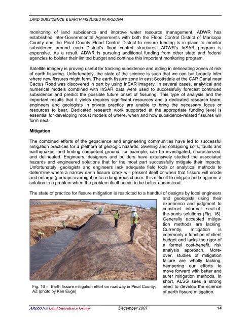
<strong>The</strong> state of practice for fissure mitigation is restricted to a h<strong>and</strong>ful of designs by local eng<strong>in</strong>eers<br />
<strong>and</strong> geologists us<strong>in</strong>g their<br />
experience <strong>and</strong> judgment to<br />
construct <strong>in</strong>formal seat-ofthe-pants<br />
solutions (Fig. 16).<br />
Generally accepted mitigation<br />
methods are lack<strong>in</strong>g.<br />
Currently, mitigation is<br />
commonly a function of client<br />
budget <strong>and</strong> lacks the rigor of<br />
a formal cost-benefit, risk<br />
analysis approach. Moreover,<br />
studies of mitigation<br />
failure are wholly lack<strong>in</strong>g,<br />
hamper<strong>in</strong>g our efforts to<br />
move forward with better <strong>and</strong><br />
surer mitigation methods. In<br />
Fig. 16 – Earth fissure mitigation effort on roadway <strong>in</strong> P<strong>in</strong>al County,<br />
AZ (photo by Ken Euge)<br />
short, ALSG sees a strong<br />
need to develop the science<br />
of <strong>earth</strong> fissure mitigation.<br />
ARIZONA L<strong>and</strong> Subsidence Group December 2007 14


