

land subsidence and earth fissures in arizona - The Arizona ...
land subsidence and earth fissures in arizona - The Arizona ...
land subsidence and earth fissures in arizona - The Arizona ...

Create successful ePaper yourself
Turn your PDF publications into a flip-book with our unique Google optimized e-Paper software.
LAND SUBSIDENCE & EARTH FISSURES IN ARIZONA<br />
2 LAND SUBSIDENCE AND EARTH FISSURES AS A GEOLOGIC PROCESS<br />
L<strong>and</strong> <strong>subsidence</strong> <strong>and</strong> <strong>earth</strong> fissure formation <strong>in</strong> <strong>Arizona</strong> are the result of substantial<br />
groundwater withdrawal from aquifers <strong>in</strong> sedimentary bas<strong>in</strong>s. Subsidence frequently results <strong>in</strong><br />
bowl-shaped depressions, with loss of elevation greatest <strong>in</strong> the center <strong>and</strong> decreas<strong>in</strong>g towards<br />
the perimeter. Earth <strong>fissures</strong>, the most spectacular manifestation of <strong>subsidence</strong>-related<br />
phenomena, occur about the marg<strong>in</strong>s of alluvial bas<strong>in</strong>s, near exposed or shallow buried<br />
bedrock, or over zones of chang<strong>in</strong>g alluvial characteristics (facies) <strong>in</strong> bas<strong>in</strong>s where differential<br />
<strong>l<strong>and</strong></strong> <strong>subsidence</strong> has occurred.<br />
Subsidence<br />
S<strong>in</strong>ce 1900, groundwater pump<strong>in</strong>g <strong>in</strong> south-central <strong>Arizona</strong> for irrigation, m<strong>in</strong><strong>in</strong>g, <strong>and</strong> municipal<br />
use has greatly outstripped recharge, <strong>in</strong> some places by a factor of 500 times. (Schumann <strong>and</strong><br />
Cripe, 1986). A total area of more than 3,000 square miles is affected by <strong>subsidence</strong>, <strong>in</strong>clud<strong>in</strong>g<br />
the exp<strong>and</strong><strong>in</strong>g metropolitan areas of Phoenix <strong>and</strong> Tucson <strong>and</strong> rapidly grow<strong>in</strong>g northern P<strong>in</strong>al<br />
County (Carpenter, 1999). In the past, groundwater was withdrawn primarily from agricultural<br />
irrigation wells. Today, municipal wells also extract groundwater, <strong>and</strong> as a result, groundwater<br />
levels cont<strong>in</strong>ue to decl<strong>in</strong>e <strong>in</strong> many areas. In places where agriculture is be<strong>in</strong>g phased out <strong>in</strong> favor<br />
of residential <strong>and</strong> commercial users <strong>and</strong> where groundwater recharge programs us<strong>in</strong>g Central<br />
<strong>Arizona</strong> Project (CAP) Colorado River water occur along with use of reclaimed wastewater,<br />
groundwater levels are stable or on the rebound. In <strong>Arizona</strong>, however, groundwater still<br />
accounts for 40% of all water use.<br />
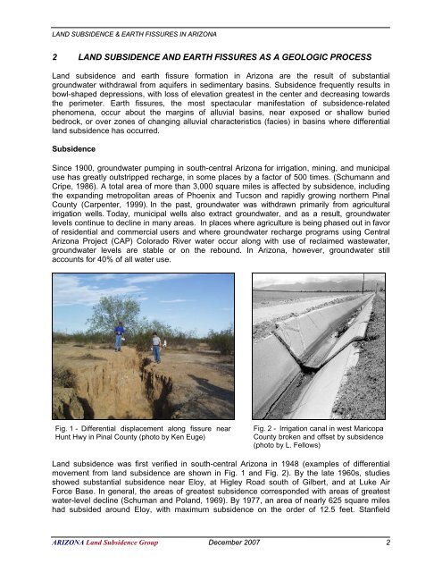
Fig. 1 - Differential displacement along fissure near<br />
Hunt Hwy <strong>in</strong> P<strong>in</strong>al County (photo by Ken Euge)<br />
Fig. 2 - Irrigation canal <strong>in</strong> west Maricopa<br />
County broken <strong>and</strong> offset by <strong>subsidence</strong><br />
(photo by L. Fellows)<br />
L<strong>and</strong> <strong>subsidence</strong> was first verified <strong>in</strong> south-central <strong>Arizona</strong> <strong>in</strong> 1948 (examples of differential<br />
movement from <strong>l<strong>and</strong></strong> <strong>subsidence</strong> are shown <strong>in</strong> Fig. 1 <strong>and</strong> Fig. 2). By the late 1960s, studies<br />
showed substantial <strong>subsidence</strong> near Eloy, at Higley Road south of Gilbert, <strong>and</strong> at Luke Air<br />
Force Base. In general, the areas of greatest <strong>subsidence</strong> corresponded with areas of greatest<br />
water-level decl<strong>in</strong>e (Schuman <strong>and</strong> Po<strong>l<strong>and</strong></strong>, 1969). By 1977, an area of nearly 625 square miles<br />
had subsided around Eloy, with maximum <strong>subsidence</strong> on the order of 12.5 feet. Stanfield<br />
ARIZONA L<strong>and</strong> Subsidence Group December 2007 2


