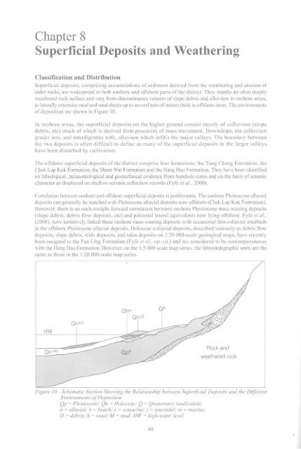
Chapter 8Superficial Deposits and WeatheringClassification and DistributionSuperficial deposits, comprising accumulations <strong>of</strong> sediment derived from the weathering and erosion <strong>of</strong>older rocks, are widespread in both onshore and <strong>of</strong>fshore parts <strong>of</strong> the district. <strong>The</strong>y mantle an <strong>of</strong>ten deeplyweathered rock surface and vary from discontinuous veneers <strong>of</strong> slope debris and alluvium in onshore areas,to laterally extensive mud and sand sheets up to several tens <strong>of</strong> metres thick in <strong>of</strong>fshore areas. <strong>The</strong> environments<strong>of</strong> deposition are shown in Figure 10.In onshore areas, the superficial deposits on the higher ground consist mostly <strong>of</strong> colluvium (slopedebris, etc) much <strong>of</strong> which is derived from processes <strong>of</strong> mass movement. Downslope, the colluviumgrades into, and interdigitates with, alluvium which infills the major valleys. <strong>The</strong> boundary betweenthe two deposits is <strong>of</strong>ten difficult to define as many <strong>of</strong> the superficial deposits in the larger valleyshave been disturbed by cultivation.<strong>The</strong> <strong>of</strong>fshore superficial deposits <strong>of</strong> the district comprise four formations; the Tung Chung Formation, theChek Lap Kok Formation, the Sham Wat Formation and the Hang Hau Formation. <strong>The</strong>y have been identifiedon lithological, palaeontological and geotechnical evidence from borehole cores and on the basis <strong>of</strong> seismiccharacter as displayed on shallow seismic reflection records (Fyfe et al., 2000).Correlation between onshore and <strong>of</strong>fshore superficial deposits is problematic. <strong>The</strong> onshore Pleistocene alluvialdeposits can generally be matched with Pleistocene alluvial deposits now <strong>of</strong>fshore (Chek Lap Kok Formation).However, there is no such straight-forward correlation between onshore Pleistocene mass wasting deposits(slope debris, debris flow deposits, etc) and potential lateral equivalents now lying <strong>of</strong>fshore. Fyfe et al.,(2000), have tentatively linked these onshore mass wasting deposits with occasional thin colluvial interbedsin the <strong>of</strong>fshore Pleistocene alluvial deposits. Holocene colluvial deposits, described variously as debris flowdeposits, slope debris, slide deposits, and talus deposits on 1:20 000-scale geological maps, have recentlybeen assigned to the Fan Ling Formation (Fyfe et al., op. cit.) and are considered to be contemporaneouswith the Hang Hau Formation. However, on the 1:5 000-scale map series, the lithostratigraphic units are thesame as those in the 1:20 000-scale map series.fQl- lie QhbSCJfHWQhmSQ h mM———Qp a^W^^Rock andweathered rock- ^Figure 10 - Schematic Section Showing the Relationship between Superficial Deposits and the DifferentEnvironments <strong>of</strong> DepositionQp = Pleistocene; Qh = Holocene; Q = Quaternary (undivided);a = alluvial; b = beach; e = estuarine; i = intertidal; m = marine;D = debris; S = sand; M = mud; HW = high-water level40
Offshore superficial deposits within the district are dominated by mud and sand <strong>of</strong> the Hang Hay Formation.<strong>The</strong>se marine deposits form a thick blanket overlying estuarine deposits <strong>of</strong> the Sham Wat Formation andalluvial sediments <strong>of</strong> the Chek Lap Kok Formation. <strong>The</strong> Chek Lap Kok Formation comprises sand banksand sand sheets to the north <strong>of</strong> Lantau Island. <strong>The</strong> sand banks have been extensively dredged and the sandused as fill material for reclamations. Beneath the Chek Lap Kok Formation, the deposits <strong>of</strong> the Tung ChungFormation infill local depressions in the weathered rock surface. <strong>The</strong> thickest accumulation <strong>of</strong> these coarseandfine-grained sediments lies in the vicinity <strong>of</strong> the type locality at the Tung Chung reclamation, andimmediately to the north <strong>of</strong> Lantau Island between Tung Chung and Yam O. At the type locality, the sedimentsinfill three separate sub-circular basins with diameters <strong>of</strong> c. 200 m, 300 m and 600 m, and reach up to96.5 m in thickness (Fyfe et ai, 2000). Subparallel with the coastline to the north <strong>of</strong> Lantau Island, thesediments locally infill a series <strong>of</strong> discontinuous deep basins which follow a northeast-trending fault-controlleddepression (Kirk et al, 2000). Contours on rockhead (Grade III or better) suggest that a palaeovalley onceformed the axis <strong>of</strong> the depression and this feature is thought to have captured water draining from northwesttrendingand west-trending valleys during a low sea level stand.Onshore Superficial DepositsSlope DebrisSlope debris consisting <strong>of</strong> locally derived material (debris flow deposits, talus deposits, etc,) is consideredto be the product <strong>of</strong> mass movement processes. This material, also referred to collectively as colluvium, iscommonly generated during periods <strong>of</strong> high rainfall. <strong>The</strong> mass movements, such as debris flows and debrisslides, may be initiated on slopes inclined at only a few degrees. Slope debris deposits commonly formaprons on the middle to lower slopes <strong>of</strong> high ground and may grade downslope into alluvium. <strong>The</strong>y comprisea structureless mixture <strong>of</strong> silt, sand, gravel, cobbles and boulders, <strong>of</strong>ten embedded in a gravelly, sandy silt tosilty clay matrix. <strong>The</strong> colour <strong>of</strong> the matrix varies from yellowish brown, through brownish grey to pink;white kaolin streaks and spots are common. <strong>The</strong> rock fragments generally show a weathered rind consistentwith significant post-depositional weathering. <strong>The</strong> slope debris in the middle to lower slopes is generally upto 10 m thick, but a maximum thickness <strong>of</strong> 17.5 m has been recorded in a borehole (TRL103/3608, 12561662) near TaiPo.Distinction between Pleistocene (Chek Lap Kok Formation) and Holocene (Fan Ling Formation) slopedebris is based on the general criteria used by Lai & Taylor (1984) and Lai (1997, 1998) for the subdivision<strong>of</strong> colluvium. <strong>The</strong>se criteria include superposition, colour, and the degree <strong>of</strong> decomposition <strong>of</strong> the clasts. Ingeneral, Pleistocene slope debris are poorly sorted, with a reddish brown or dark yellowish brown to orangishred, slightly mottled slightly clayey sandy silty matrix containing subangular, slightly to moderatelydecomposed boulders and cobbles. In contrast, the Holocene colluvial deposits have a fresher appearance,without the distinctive mottling <strong>of</strong> the matrix. <strong>The</strong>y are described as poorly sorted, with a light yellowishbrown, slightly clayey sandy silt to gravelly silty sand matrix containing subangular to angular slightlydecomposed boulders with weathering rinds only a few millimetres thick.<strong>The</strong> distribution <strong>of</strong> slope deposits within the district has been determined by surface morphology. Pleistoceneslope debris deposits have been mapped in the middle to lower reaches <strong>of</strong> the major valleys (e.g. Tin Sam,Tung Chung, and Wong Lung Hang), and as thick fan aprons on the northwest-facing slopes above Tai Po,east <strong>of</strong> Tung Chung. In the lower parts <strong>of</strong> the main valleys, the slope deposits are commonly gradationalinto, or overlain by, Pleistocene alluvium. In places (e.g. Tin Sam valley), the Pleistocene slope debrisdeposits extend almost to the coastline.Holocene slope debris within the district is mostly confined to the upland areas and heads <strong>of</strong> stream courses.In the upland areas, the Holocene debris forms discontinuous veneers on the weathered bedrock. In theheads <strong>of</strong> stream courses, the slope debris forms minor dendritic networks. Deposits <strong>of</strong> slope debris whichalmost reach sea level are thought to be the products <strong>of</strong> large debris flows.Alluvial SedimentsAlluvial deposits <strong>of</strong> the district are generally thicker and more widespread than the slope debris deposits.<strong>The</strong> alluvium infills the floors <strong>of</strong> many <strong>of</strong> the larger valleys and has, in many cases, been significantlymodified by cultivation.41
- Page 2 and 3: THE UNIVERSITY OF HONG KONGLIBRARIE
- Page 4 and 5: ,11 DEC'£• Government of the Hon
- Page 7: CONTENTSPageTitle Page 1Foreword 3C
- Page 10: 11 Location Map Showing the Distrib
- Page 18 and 19: Seismic reflection line8Onshore are
- Page 20 and 21: Table 2 - Summary of the Onshore an
- Page 23: These faults offset the caldera bou
- Page 27 and 28: Chapter 4Mesozoic Sedimentary and V
- Page 29 and 30: Tuffite. A prominent outcrop of ban
- Page 31 and 32: Lantau GraniteThe Lantau Granite is
- Page 33 and 34: " .-.": •' - • • *"» JI i I
- Page 35 and 36: Quartz VeinsQuartz veins are ubquit
- Page 37 and 38: LEGENDOoI2PhotolineamentFaultConcea
- Page 39 and 40: No. of Joints measured=82No. of Joi
- Page 41: Chapter 7Metamorphism and Alteratio
- Page 45 and 46: Plate 8 - Tung Chung Wan from the N
- Page 47 and 48: Sham Wat FormationThe formation, kn
- Page 49 and 50: to infill depressions and channels
- Page 52: ased on recommendations contained i
- Page 57 and 58: over a wider area. The survey resul
- Page 59 and 60: Chapter 10Economic GeologyEconomic
- Page 61 and 62: ReferencesAllen, P.M. & Stephens, E
- Page 63 and 64: Li, X.C., Sewell, RJ. & Fletcher, C
- Page 65 and 66: microgranite, 17, 28, 31, 32, 48 Tu
- Page 67 and 68: Marine sedimentDescriptionUnconsoli
- Page 73: Plate Ala- Marble. The generally da
- Page 76 and 77: Plate A9 - Skarn from Site 3 showin
- Page 78 and 79: 1 8Plate Alia - Cavity-fill deposit
- Page 80 and 81: Plate A12b - Pervasively weathered
- Page 82 and 83: RhyoliteDescriptionAcid igneous roc
- Page 84 and 85: Plate A 16a - Pervasively weathered
- Page 86 and 87: 1 f < 1 9 2 OPlate A 18b - A Itered
- Page 88 and 89: 2 1 2 2Plate A21 - Lamprophyric roc
- Page 90 and 91: Residual soil derived from metasedi