AppendixLEXICON OF TERMS USED FOR DRILLCORE LOGGING AND SURFACEMAPPING AT TUNG CHUNG, LANTAU ISLAND, HONG KONG(Reproduced, with minor amendments, from a report prepared for theGEO, CED, by M. R. Gillespie, A. J. Humpage and R. A. Ellison, November 1998)IntroductionThis document outlines the geological terms recommended for use during drillcore logging and surfacemapping <strong>of</strong> rocks and superficial deposits at Tung Chung New Town, Lantau Island, <strong>Hong</strong> <strong>Kong</strong>. <strong>The</strong> termsand their definitions are based largely on those described in <strong>Hong</strong> <strong>Kong</strong> Geological Survey Memoir No. 6(Geology <strong>of</strong> Lantau District; Langford et al 1995) and in Geoguide 3, the 'Guide to Rock and SoilDescriptions' produced by the Geotechnical Engineering Office, Civil Engineering Department, <strong>Hong</strong> <strong>Kong</strong>.Descriptions <strong>of</strong> all the key lithologies and geological features encountered in the Tung Chung drillcores arepresented. <strong>The</strong>se are based primarily on visual examination <strong>of</strong> drillcore in a wettened state, using a handlens where appropriate. Useful additional information is provided by the acid test (using 10% HC1 to detectcalcite), and a hardness (scratch) test using a steel knife.A list <strong>of</strong> key diagnostic features and, where appropriate, one or more photographs accompany the briefdescription provided for each recommended term. Significant differences in the character <strong>of</strong> lithologiesbetween the main sites (Sites 3,4 and 5) investigated within the Tung Chung New Town Area (Figure 1) arenoted. Grain size terms are defined in Table 5 <strong>of</strong> Geoguide 3.One or more reference samples <strong>of</strong> most <strong>of</strong> the Tung Chung lithologies has been collected and is stored by the<strong>Hong</strong> <strong>Kong</strong> Geological Survey, Geotechnical Engineering Office, Civil Engineering Department, <strong>Hong</strong><strong>Kong</strong>. <strong>The</strong>se are mainly hand samples <strong>of</strong> drillcore, each <strong>of</strong> which has been assigned an identificationnumber (e.g. Reference sample no. 1). However, Mazier samples, whole drillcore boxes and several completedrillcores also form part <strong>of</strong> the reference sample collection. <strong>The</strong> reference sample numbers, or the boreholename and depth <strong>of</strong> the other types <strong>of</strong> reference samples, are referred to at appropriate points in the text.In photographs showing drillcore in boxes, or parts <strong>of</strong> boxes, the shallowest part <strong>of</strong> the core is at top left, thedeepest part at bottom right.LexiconFillDescriptionMan-made deposit composed mainly <strong>of</strong> sand, gravel and shell fragments, with occasional boulders, cobbles,wood and synthetic materials. Table 18 in Geoguide 3 summarises some <strong>of</strong> the features associated with fill.Key diagnostic features :(i) Mainly sand, gravel and shell fragments.Occasional boulders, cobbles, wood and synthetic materials.(ii) Unconsolidated.(iii) No structure.(iv) Usually light brown to grey.Reference sample no.: Fill is represented in all the whole reference drillcores.64
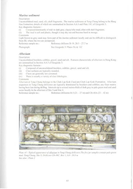
Marine sedimentDescriptionUnconsolidated mud, sand, silt, shell fragments. <strong>The</strong> marine sediments at Tung Chung belong to the HangHau Formation, details <strong>of</strong> which are summarised in Section A.6.4 and Plate 11C <strong>of</strong> Geoguide 3.Key diagnostic features :(i) Composed dominantly <strong>of</strong> mid- to dark grey, clayey/silty mud, <strong>of</strong>ten with shell fragments.(ii) <strong>The</strong> mud is s<strong>of</strong>t and plastic, though it may dry out and become hard in storage.CommentsLight brown to grey sand may form part <strong>of</strong> the marine sediment locally and can be difficult to distinguishfrom fill, where the two are juxtaposed.Reference sample no.:Reference drillcore B-19, 20.5 - 27.7 mPhotograph:See Geoguide 3: Plates 9A & 11CAlluviumDescriptionUnconsolidated boulders, cobbles, gravel, sand and silt. Features characteristic <strong>of</strong> alluvium in <strong>Hong</strong> <strong>Kong</strong>are summarised in Section A.6.3 <strong>of</strong> Geoguide 3.Key diagnostic features :(i) Composed <strong>of</strong> unconsolidated boulders, cobbles, gravel, sand and silt.(ii) Clast surfaces are typically rounded.(iii) Clasts are generally not cemented.(iv) <strong>The</strong>re is usually a variety <strong>of</strong> clast lithologies.CommentsAlluvium at Tung Chung belongs to the Chek Lap Kok (?and pre-Chek Lap Kok) Formation. Alluviumsequences in Tung Chung drillcores are typically dominated by boulders and cobbles, any finer matrixhaving been lost during drilling. Intervals up to several metres thick <strong>of</strong> dark grey to pale green mud and sandoccur locally in the alluvium <strong>of</strong> Site 3 and Site 4.Reference sample no.: Reference drillcores B-5 (21-27 m) and CB-46A (21-42 m)Plate A1 - Typical appearance <strong>of</strong> alluvium in Tung Chung drillcores. <strong>The</strong> five jar samples contain pale greenmud. Tung Chung, Site 3; Drillcore CB-49C; Box 1,0.0- 39.0 mSee also : Plate 265
- Page 2 and 3:
THE UNIVERSITY OF HONG KONGLIBRARIE
- Page 4 and 5:
,11 DEC'£• Government of the Hon
- Page 7:
CONTENTSPageTitle Page 1Foreword 3C
- Page 10:
11 Location Map Showing the Distrib
- Page 18 and 19: Seismic reflection line8Onshore are
- Page 20 and 21: Table 2 - Summary of the Onshore an
- Page 23: These faults offset the caldera bou
- Page 27 and 28: Chapter 4Mesozoic Sedimentary and V
- Page 29 and 30: Tuffite. A prominent outcrop of ban
- Page 31 and 32: Lantau GraniteThe Lantau Granite is
- Page 33 and 34: " .-.": •' - • • *"» JI i I
- Page 35 and 36: Quartz VeinsQuartz veins are ubquit
- Page 37 and 38: LEGENDOoI2PhotolineamentFaultConcea
- Page 39 and 40: No. of Joints measured=82No. of Joi
- Page 41 and 42: Chapter 7Metamorphism and Alteratio
- Page 43 and 44: Offshore superficial deposits withi
- Page 45 and 46: Plate 8 - Tung Chung Wan from the N
- Page 47 and 48: Sham Wat FormationThe formation, kn
- Page 49 and 50: to infill depressions and channels
- Page 52: ased on recommendations contained i
- Page 57 and 58: over a wider area. The survey resul
- Page 59 and 60: Chapter 10Economic GeologyEconomic
- Page 61 and 62: ReferencesAllen, P.M. & Stephens, E
- Page 63 and 64: Li, X.C., Sewell, RJ. & Fletcher, C
- Page 65: microgranite, 17, 28, 31, 32, 48 Tu
- Page 73: Plate Ala- Marble. The generally da
- Page 76 and 77: Plate A9 - Skarn from Site 3 showin
- Page 78 and 79: 1 8Plate Alia - Cavity-fill deposit
- Page 80 and 81: Plate A12b - Pervasively weathered
- Page 82 and 83: RhyoliteDescriptionAcid igneous roc
- Page 84 and 85: Plate A 16a - Pervasively weathered
- Page 86 and 87: 1 f < 1 9 2 OPlate A 18b - A Itered
- Page 88 and 89: 2 1 2 2Plate A21 - Lamprophyric roc
- Page 90 and 91: Residual soil derived from metasedi