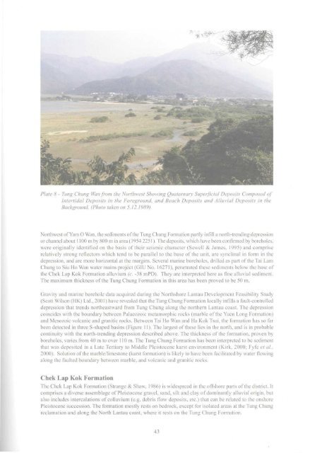
Both the Pleistocene and Holocene alluvial deposits have been mapped in the district mainly by aerialphotograph interpretation. In general the Pleistocene alluvial deposits form elevated terraces whichhave been incised by recent streams, whereas Holocene alluvial deposits are largely confined to thebeds <strong>of</strong> recent stream courses. <strong>The</strong> alluvial deposits consist mostly <strong>of</strong> well-sorted to semi-sorted clay,silt, gravel and sand.Pleistocene alluvial deposits have been mapped in several <strong>of</strong> the major valleys in the district, and are commonlyassociated with Pleistocene slope debris deposits. Extensive deposits <strong>of</strong> Pleistocene alluvium, now modifiedby cultivation, form the floors <strong>of</strong> valleys at Sha Lo Wan, Tin Sam, Tung Chung, Wong Lung Hang, and PakMong. In the Tung Chung area, the Pleistocene alluvium consists <strong>of</strong> cobbles and boulders surrounded by amottled red and yellow sandy silt with some lenses and layers <strong>of</strong> sand. Thicknesses <strong>of</strong> alluvium recorded inboreholes vary from 5 to 20 m. <strong>The</strong> Pleistocene alluvial deposits were laid down under various conditions <strong>of</strong>deposition, but mostly fomied as fans and deltas at the bases <strong>of</strong> extensive debris deposits. During periods <strong>of</strong>active erosion <strong>of</strong> nearby hills, coarse sandy material was deposited near to the source area. At other times, aquieter environment existed, allowing far-travelled silts and muds to be laid down.Holocene alluvial deposits within the district mainly occupy the beds <strong>of</strong> recent streams and form small fandeltas where these streams enter the sea. <strong>The</strong> largest deposits are found at Sha Lo Wan, Tung Chung, WongLung Hang and Pak Mong. <strong>The</strong> Holocene alluvium consists mostly <strong>of</strong> gravelly sand with subrounded cobblesand boulders in the stream courses, or yellowish-brown, well sorted clayey sand or silt in the deltas. In theTung Chung valley, Holocene alluvium forms a series <strong>of</strong> narrow strips along the present stream courses.<strong>The</strong>se are incised into the Pleistocene alluvial terraces.Beach DepositsBeach deposits are exposed in many <strong>of</strong> the areas <strong>of</strong> remaining natural coastline, particularly the shelteredbays to the west <strong>of</strong> Tung Chung. <strong>The</strong>se deposits consist <strong>of</strong> unconsolidated, mainly sand-sized material andoccupy the narrow strip <strong>of</strong> land extending from the low-water mark to the upper limit <strong>of</strong> wave action,usually delineated by either a cliff line, or storm beach. Prior to reclamation, beach deposits occurred alonga large portion <strong>of</strong> the natural coastline between Pak Mong and Lau Fau Sha.At Sha Lo Wan and Hau Hok Wan, broad (100 m wide) sand beaches have developed consisting <strong>of</strong> clean,yellowish brown, fine- to medium-grained sand. Small pockets <strong>of</strong> beach sand have also accumulated in gapsalong the rocky coastline between these two beaches. At Tin Sam, a narrow (25 m wide) sand beach hasdeveloped on the edge <strong>of</strong> the small delta.Intertidal DepositsIntertidal deposits <strong>of</strong> mixed alluvial and marine origin have been mapped between Tin Sam and Tung ChungWan (Plate 8). <strong>The</strong>y consist <strong>of</strong> s<strong>of</strong>t dark grey to yellowish brown clayey silty sands with plant remains, anddark grey, organic silt with shell fragments, and are generally confined between the low and high watermarks. At Tung Chung Wan, the intertidal deposits are characterised by mangrove-lined channels and sandysplays.Offshore Superficial DepositsTung Chung Formation<strong>The</strong> Tung Chung Formation (Kirk, 2000; Fyfe et al, 2000) is the name given for coarse- and fine-grainedsediments which infill local depressions <strong>of</strong>fshore in the weathered rock surface near Tung Chung and alongthe north coast <strong>of</strong> Lantau Island. <strong>The</strong>se sediments were first identified on the basis <strong>of</strong> their seismic characterand were previously termed "Pre-Chek Lap Kok Formation Deposits" (Langford et al, 1995).<strong>The</strong> Tung Chung Formation has been formally defined from boreholes at the Tung Chung reclamation (Fyfeet ah, 2000), At the type borehole (CC10/WO2893, 1215 1704), the formation comprises boulders <strong>of</strong>completely decomposed fine-grainedgranite and feldsparphyric rhyolite, intercalated with yellowish brownsilty sand, reddish brown sandy silt, matrix-supported gravel conglomerate, and brown, fme-grained micaceoussand with minor clay laminae. <strong>The</strong> formation unconformably overlies Mesozoic or older rocks, and isconformably overlain by the Chek Lap Kok Formation.42
Plate 8 - Tung Chung Wan from the Northwest Showing Quaternary Superficial Deposits Composed <strong>of</strong>Intertidal Deposits in the Foreground, and Beach Deposits and Alluvial Deposits in theBackground. (Photo taken on 5.12.1989)Northwest <strong>of</strong> Yam O Wan, the sediments <strong>of</strong> the Tung Chung Formation partly infill a north-trending depressionor channel about 1100 m by 800 m in area (1954 2251). <strong>The</strong> deposits, which have been confirmed by boreholes,were originally identified on the basis <strong>of</strong> their seismic character (Sewell & James, 1995) and compriserelatively strong reflectors which tend to be parallel to the base <strong>of</strong> the unit, are synclinal in form in thedepression, and are more horizontal at the margins. Several marine boreholes, drilled as part <strong>of</strong> the Tai LamChung to Siu Ho Wan water mains project (GIU No. 16271), penetrated these sediments below the base <strong>of</strong>the Chek Lap Kok Formation alluvium (c. -38 mPD). <strong>The</strong>y are interpreted here as fine alluvial sediment.<strong>The</strong> maximum thickness <strong>of</strong> the Tung Chung Formation in this area has been proved to be 50 m.Gravity and marine borehole data acquired during the Northshore Lantau Development Feasibility Study(Scott Wilson (HK) Ltd., 2001) have revealed that the Tung Chung Formation locally infills a fault-controlleddepression that trends northeastward from Tung Chung along the northern Lantau coast. <strong>The</strong> depressioncoincides with the boundary between Palaeozoic metamorphie rocks (marble <strong>of</strong> the Yuen Long Formation)and Mesozoic volcanic and granitic rocks. Between Tai Ho Wan and Ha Kok Tsui, the formation has so farbeen detected in three S-shaped basins (Figure 11). <strong>The</strong> largest <strong>of</strong> these lies in the north, and is in probablecontinuity with the north-trending depression described above. <strong>The</strong> thickness <strong>of</strong> the formation, proven byboreholes, varies from 40 m to over 110m. <strong>The</strong> Tung Chung Formation has been interpreted to be sedimentthat was deposited in a Late Tertiary to Middle Pleistocene karst environment (Kirk, 2000; Fyfe et al,2000). Solution <strong>of</strong> the marble/limestone (karst formation) is likely to have been facilitated by water flowingalong the faulted boundary between marble, and volcanic and granitic rocks.Chek Lap Kok Formation<strong>The</strong> Chek Lap Kok Formation (Strange & Shaw, 1986) is widespread in the <strong>of</strong>fshore parts <strong>of</strong> the district. Itcomprises a diverse assemblage <strong>of</strong> Pleistocene gravel, sand, silt and clay <strong>of</strong> dominantly alluvial origin, butalso includes intercalations <strong>of</strong> colluvium (e.g. debris flow deposits, etc.) that can be related to the onshorePleistocene succession. <strong>The</strong> formation mostly rests on bedrock, except for isolated areas at the Tung Chungreclamation and along the North Lantau coast, where it rests on the Tung Chung Formation.43
- Page 2 and 3: THE UNIVERSITY OF HONG KONGLIBRARIE
- Page 4 and 5: ,11 DEC'£• Government of the Hon
- Page 7: CONTENTSPageTitle Page 1Foreword 3C
- Page 10: 11 Location Map Showing the Distrib
- Page 18 and 19: Seismic reflection line8Onshore are
- Page 20 and 21: Table 2 - Summary of the Onshore an
- Page 23: These faults offset the caldera bou
- Page 27 and 28: Chapter 4Mesozoic Sedimentary and V
- Page 29 and 30: Tuffite. A prominent outcrop of ban
- Page 31 and 32: Lantau GraniteThe Lantau Granite is
- Page 33 and 34: " .-.": •' - • • *"» JI i I
- Page 35 and 36: Quartz VeinsQuartz veins are ubquit
- Page 37 and 38: LEGENDOoI2PhotolineamentFaultConcea
- Page 39 and 40: No. of Joints measured=82No. of Joi
- Page 41 and 42: Chapter 7Metamorphism and Alteratio
- Page 43: Offshore superficial deposits withi
- Page 47 and 48: Sham Wat FormationThe formation, kn
- Page 49 and 50: to infill depressions and channels
- Page 52: ased on recommendations contained i
- Page 57 and 58: over a wider area. The survey resul
- Page 59 and 60: Chapter 10Economic GeologyEconomic
- Page 61 and 62: ReferencesAllen, P.M. & Stephens, E
- Page 63 and 64: Li, X.C., Sewell, RJ. & Fletcher, C
- Page 65 and 66: microgranite, 17, 28, 31, 32, 48 Tu
- Page 67 and 68: Marine sedimentDescriptionUnconsoli
- Page 73: Plate Ala- Marble. The generally da
- Page 76 and 77: Plate A9 - Skarn from Site 3 showin
- Page 78 and 79: 1 8Plate Alia - Cavity-fill deposit
- Page 80 and 81: Plate A12b - Pervasively weathered
- Page 82 and 83: RhyoliteDescriptionAcid igneous roc
- Page 84 and 85: Plate A 16a - Pervasively weathered
- Page 86 and 87: 1 f < 1 9 2 OPlate A 18b - A Itered
- Page 88 and 89: 2 1 2 2Plate A21 - Lamprophyric roc
- Page 90 and 91: Residual soil derived from metasedi